Method and system for searching positions on topographic map of K-D tree based on curve

A search method and topographic map technology, applied in geographic information databases, other database retrieval, structured data retrieval, etc., can solve difficult and complex problems, and achieve the effect of easy implementation, small conformal deformation, and topology structure maintenance

Pending Publication Date: 2022-05-27
XI AN JIAOTONG UNIV
View PDF0 Cites 0 Cited by
  • Summary
  • Abstract
  • Description
  • Claims
  • Application Information

AI Technical Summary

Problems solved by technology

Among all the proposed point positioning methods, the optimal query time is O(lgn) and the storage complexity is O(n), which are relatively complicated and difficult to implement

Method used


Image

  • Method and system for searching positions on topographic map of K-D tree based on curve
  • Method and system for searching positions on topographic map of K-D tree based on curve
  • Method and system for searching positions on topographic map of K-D tree based on curve

Examples


Embodiment Construction

[0043] Below in conjunction with accompanying drawing, the present invention is described in further detail:

[0044] like Figure 5 As shown, a position search method based on a curve-based K-D tree includes the following steps:

[0045] S1, using the LCC projection method to generate a two-dimensional map from the geographic map data;

[0046] Geographic map data includes subdivision curves at different levels and latitude and longitude coordinate information of geographic boundaries;

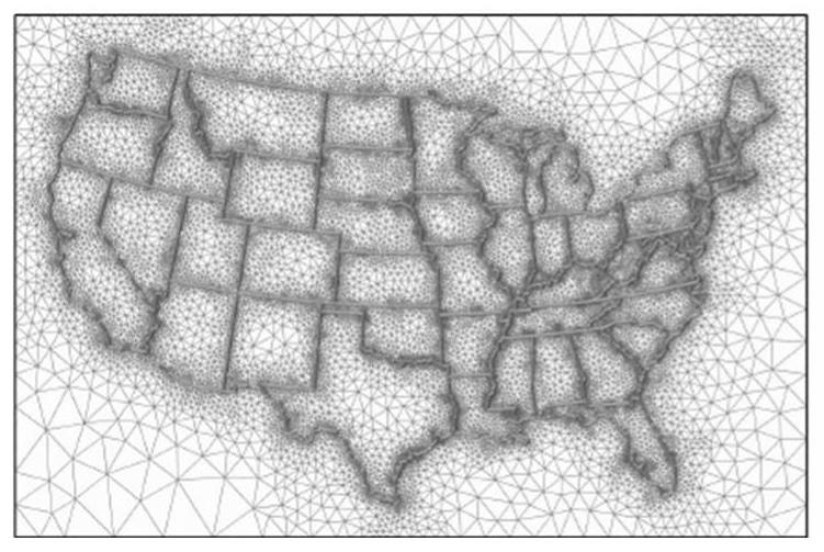
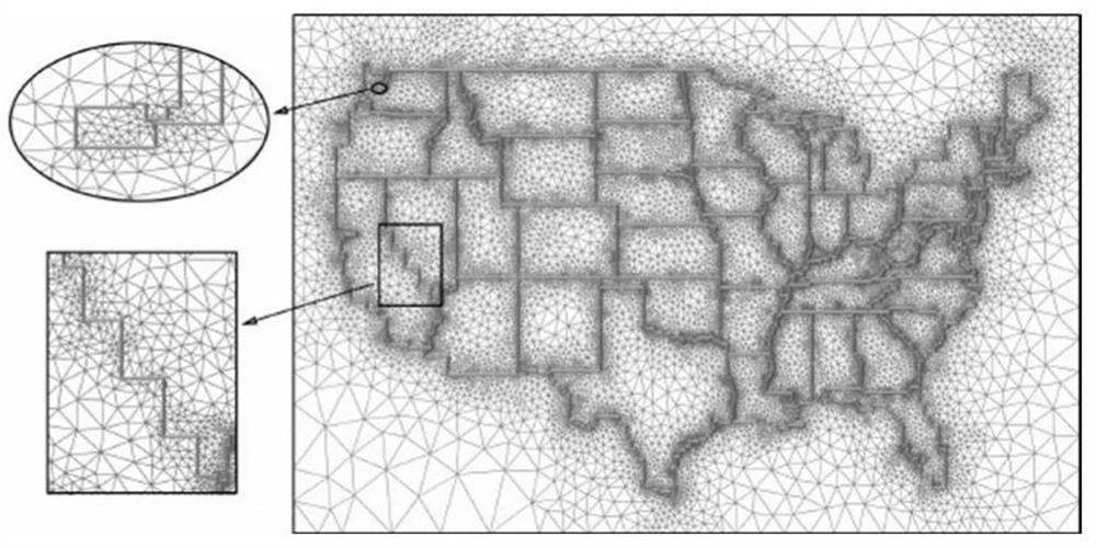
[0047] like Figure 1a , Figure 1b As shown, the straight line maps generated by the quasi-conformal mapping method are respectively performed for part of the map of China and part of the topographic map of the United States, where θ is set s =15°, ε s = 0.013, get RL(1); set θ s =40°, ε s =0.013, RL is obtained.

[0048] S2, perform type classification processing on each feature edge contained in the generated two-dimensional map;

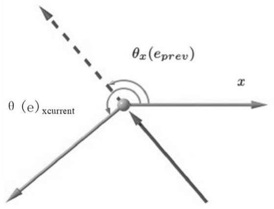
[0049] Specifically, S2.1, extract all curve segme...


PUM


Abstract

The invention discloses a method and a system for searching positions on a topographic map based on a curve K-D tree, and the method comprises the steps: enabling geographic map data to generate a two-dimensional map through an LCC projection method, and carrying out the type classification processing of each feature edge in the generated two-dimensional map, a Delaunay triangulation algorithm is used for generating a single-boundary planar triangular grid for a two-dimensional map, a curve-based k-d tree is constructed on a linear topographic map based on a point query method of the linear topographic map, point position query is simplified to search for the nearest edge of a query point, a positioned area can be obtained through k-d tree search, and the positioning accuracy is improved. The method is easy to implement and is a quasi-conformal linear mapping method for solving an extreme value in the shape closest to an original map, the structural linear topographic map considers constraints of different types and levels, has flexibility in the level, can be used as a reference map of a geographic application program, and can be used as a reference map of the geographic application program on the basis of the quasi-conformal linear topographic map. Point positioning search on a topographic map is accelerated based on a k-d tree of a data structure curve.

Description

technical field [0001] The invention relates to a curve-based k-d tree to speed up a point positioning search method based on a straight line map, in particular to a curve-based K-D tree position search method and system on a topographic map. Background technique [0002] The point localization problem is a fundamental problem of computational geometry and has been widely used in computer graphics and geographic information systems. In the case of geographic subdivision of the topographic map, the point problem is to determine the area where the query point is located, which often occurs and requires real-time results. Therefore, it is worth preprocessing the topographic map and storing it in a data structure so that point location queries can be answered quickly. Many solutions have been proposed for the point problem. Among all the proposed point localization methods, the optimal query time is O(lgn) and the storage complexity is O(n), which are complex and difficult to ...

Claims


Application Information

Patent Timeline
Patent Type & Authority Applications(China)
IPC IPC(8): G06F16/9537G06F16/29G06F16/901
CPCG06F16/9537G06F16/29G06F16/9027
Inventor 曾薇杨义军毕玉莉胡文辉王耀赵向文代凯张兴军
Owner XI AN JIAOTONG UNIV
Why Eureka
Try Eureka