Surveying and mapping data acquisition method and system based on geospatial information data

A geospatial information and data acquisition system technology, applied in surveying and mapping, navigation, measuring instruments, measuring devices, etc., can solve the problems of long construction period, time-consuming and laborious re-acquisition, etc., and achieve accurate and effective data

Active Publication Date: 2022-06-03
成都纵横通达信息工程有限公司
View PDF22 Cites 0 Cited by
  • Summary
  • Abstract
  • Description
  • Claims
  • Application Information

AI Technical Summary

Problems solved by technology

[0004] In the actual collection of surveying and mapping data, the data processing requires that after the field data is collected, the instrument returns to the company for data communication, and then the office data is processed and edited. The construction period is long, and once the collected data is wrong, it takes time to re-collect. Therefore, how to ensure that the collected data is accurate and effective is a topic that researchers need to study

Method used


Image

  • Surveying and mapping data acquisition method and system based on geospatial information data
  • Surveying and mapping data acquisition method and system based on geospatial information data

Examples


Embodiment Construction

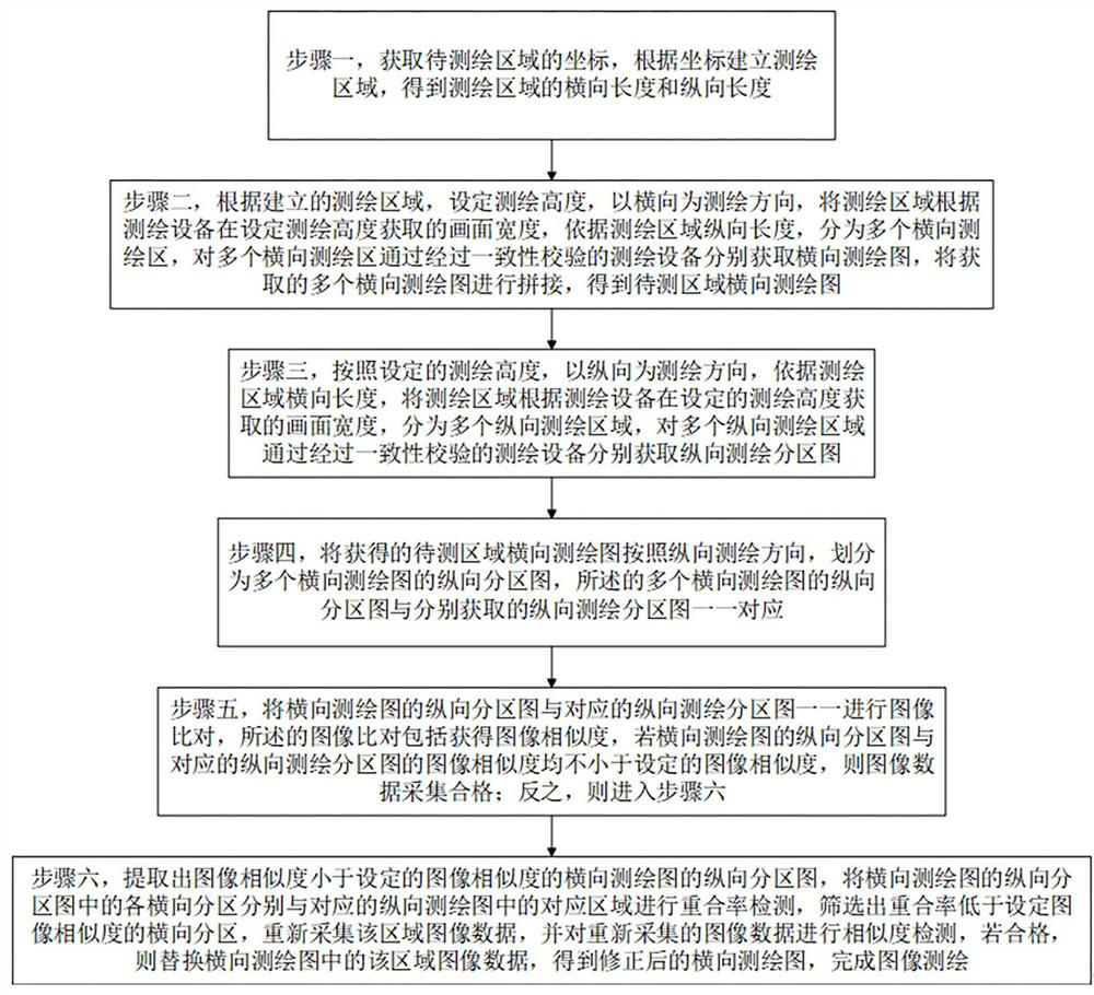
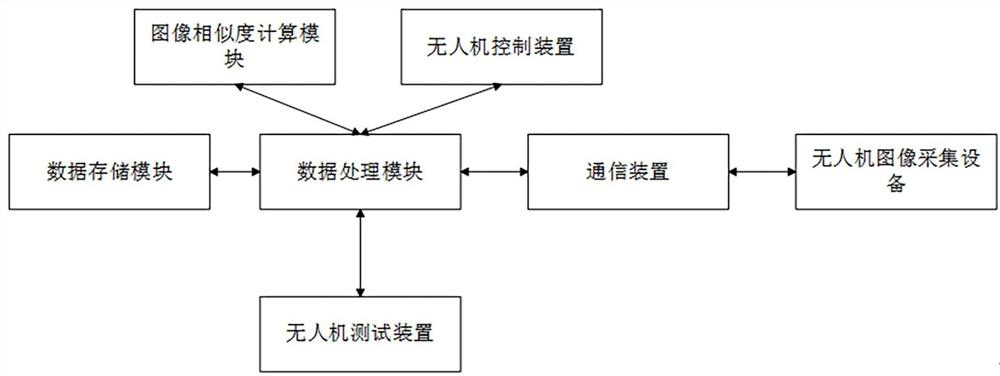
[0015] The technical solutions of the present invention are further described in detail below with reference to the accompanying drawings, but the protection scope of the present invention is not limited to the following.

[0016] In order to make the objectives, technical solutions and advantages of the present invention clearer, the present invention will be further described in detail with reference to the accompanying drawings and embodiments. It should be understood that the specific embodiments described herein are only used to explain the present invention, but not to limit the present invention, that is, the described embodiments are only a part of the embodiments of the present invention, rather than all the embodiments. The components of the embodiments of the invention generally described and illustrated in the drawings herein may be arranged and designed in a variety of different configurations.

[0017] Thus, the following detailed description of the embodiments o...


PUM


Abstract

The invention discloses a surveying and mapping data acquisition method and system based on geospatial information data, and the method comprises the steps: building a surveying and mapping region according to coordinates, and obtaining a transverse surveying and mapping graph of a to-be-measured region according to the built surveying and mapping region; according to the set surveying and mapping height, longitudinal surveying and mapping partition maps are obtained with the longitudinal direction as the surveying and mapping direction; dividing the obtained transverse surveying and mapping graph of the to-be-measured area into a plurality of longitudinal partition graphs of the transverse surveying and mapping graph according to the longitudinal surveying and mapping direction, and performing image comparison on the longitudinal partition graphs of the transverse surveying and mapping graph and the corresponding longitudinal surveying and mapping partition graphs one by one, if the image similarity between the longitudinal partition map of the transverse surveying and mapping map and the corresponding longitudinal surveying and mapping partition map is not less than the set image similarity, determining that the image data acquisition is qualified; and completing image surveying and mapping. Through the technical scheme provided by the invention, the acquired data can be identified during data acquisition, and the acquired data is ensured to be accurate and effective.

Description

technical field [0001] The invention relates to geographic information measurement, in particular to a surveying and mapping data collection method and system based on geographic spatial information data. Background technique [0002] Geographical information refers to the information related to spatial geographic distribution, which represents the data, quality, distribution characteristics, connection and regularity inherent in the surface objects and the environment, such as numbers, texts, graphics, images, etc. In the protection and other work, land surveying and surveying and mapping of various maps must be carried out for planning and management use. In geological exploration, mineral development, water conservancy, transportation and other construction, control surveying, mine surveying, route surveying and topographic map drawing must be carried out. It is used for geological census and the design and construction of various buildings. Since the terrain and regional...

Claims


Application Information

Patent Timeline
IPC IPC(8): G01C15/00
CPCG01C15/00Y02A90/30
Inventor 黄明赵彦东蔡姗姗许国强
Owner 成都纵横通达信息工程有限公司
Why Eureka
Try Eureka