
Tidal flat vegetation region terrain inversion method and system

A terrain and vegetation technology, which is applied in the directions of instruments, height/horizontal measurement, surveying and navigation, etc., can solve the problem that the terrain under the vegetation cannot be accurately measured, and achieve the effect of saving cost and material resources and improving terrain accuracy

Pending Publication Date: 2022-06-07
EAST CHINA NORMAL UNIV
View PDF4 Cites 0 Cited by
  • Summary
  • Abstract
  • Description
  • Claims
  • Application Information

AI Technical Summary

Problems solved by technology

[0004] The purpose of the present invention is to provide a terrain inversion method and system in tidal flat vegetation area, based on oblique photography three-dimensional reconstruction technology and low-altitude vegetation remote sensing technology, it solves the problem of tidal flat vegetation coverage area with short ebb time and limited observation time. The problem of being unable to be accurately measured improves the accuracy of tidal flat terrain monitoring under vegetation coverage

Method used


Image

  • Tidal flat vegetation region terrain inversion method and system
  • Tidal flat vegetation region terrain inversion method and system
  • Tidal flat vegetation region terrain inversion method and system

Examples


Embodiment 1

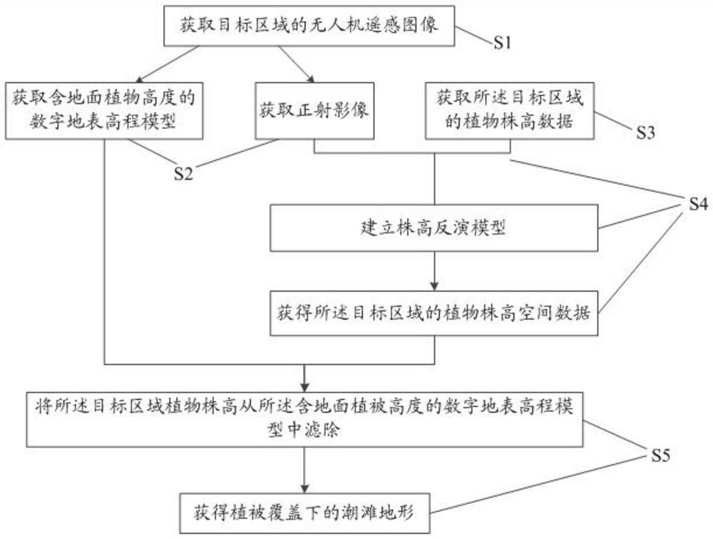
[0049] see figure 1 , this embodiment provides a terrain inversion method for a tidal flat vegetation area, including:

[0050] Step S1: obtaining a remote sensing image of the target area.

[0051] Among them, in order to ensure the inversion accuracy of the tidal flat terrain, it is possible to obtain high-overlap and high-resolution UAV remote sensing images of the target area. The flight path is obtained by photographing the target area.

[0052] It should be noted that, before flying, charge the battery and spare battery, test whether the equipment works normally, and use the flight control (hereinafter referred to as the flight control) software to plan the flight route in advance. Use the flight control software (such as DJI's DJ GS). ) When planning the flight route in advance, you can first determine the boundary of the monitoring area through the latitude and longitude on the geographic information platform (such as Google Earth, etc.), save it as a surface file in...

Embodiment 2

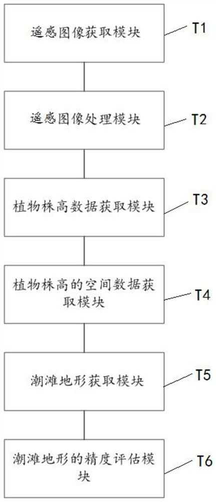
[0097] like image 3 As shown, this embodiment provides a terrain inversion system for a tidal flat vegetation area, including:

[0098] The remote sensing image acquisition module T1 is used to capture remote sensing images of the target area by using the UAV equipped with a visible light camera according to the set flight route.

[0099] The remote sensing image processing module T2 is used to generate a digital surface elevation model and an orthophoto including the height of ground plants according to the remote sensing image, and use the orthophoto to calculate the vegetation index and the spatial distribution data of the vegetation index.

[0100] The plant height data acquisition module T3 is used to randomly select several quadrats in the target area, record the center coordinates of each quadrat, and measure the average plant height of each quadrat and each quadrat. The vegetation index of each quadrat.

[0101] The spatial data acquisition module T4 of plant height...


PUM


Abstract

The invention provides a tidal flat vegetation region terrain inversion method and system, and belongs to the technical field of geological survey, and the tidal flat vegetation region terrain inversion method comprises the steps: obtaining a remote sensing image of a target region; generating a digital surface elevation model containing ground plant height and an orthoimage according to the remote sensing image; in the target area, randomly selecting a plurality of quadrats, recording the center coordinate of each quadrat, and measuring the average plant height of each quadrat and the vegetation index of each quadrat; and establishing a plant height inversion model according to the average plant height and the vegetation index of each quadrat. According to the plant inversion model and the orthoimage, determining spatial distribution data of the plant height of the target area; and according to the spatial distribution data of the plant height, accurately filtering the plant height of the covering plant on the surface of the target area from the digital surface elevation model containing the ground plant height so as to obtain the high-precision tidal flat terrain under vegetation coverage.

Description

[0001] This application is a divisional application of a patent application entitled "A Method and System for Tidal Flat Topography Inversion". The application date of the original application is March 2, 2021, and the application number is 202110228043.5. technical field [0002] The invention belongs to the technical field of geological measurement, and relates to a terrain inversion method and system under a tidal flat vegetation layer based on a three-dimensional reconstruction technology of oblique photography and a low-altitude vegetation remote sensing technology. Background technique [0003] The beach elevation is the embodiment of the morphological characteristics of the tidal flat. The observation of the beach elevation at different times can reflect the scour and deposition dynamics and the evolution of the tidal flat in the region. It is also an important factor affecting the dynamics of the tidal flat and the distribution of salt marsh vegetation. Studies have s...

Claims


Application Information

Patent Timeline
Patent Type & Authority Applications(China)
IPC IPC(8): G01C11/00G01C11/04G01C5/00
CPCG01C11/00G01C11/04G01C5/00
Inventor 袁琳李阳田波赵志远曹浩冰张晋磊张利权
Owner EAST CHINA NORMAL UNIV
Learn More