Remote sensing identification method for land cover and planting structure of finely-divided agricultural area
A planting structure and remote sensing recognition technology, applied in the field of agricultural remote sensing, can solve the problems of a large number of measured samples, time-consuming and laborious, and a single classification algorithm takes a long time to calculate, so as to achieve strong operability, reduce time cost and money cost, and ensure classification accuracy and stability effects
Pending Publication Date: 2022-06-10
CHINA AGRI UNIV
View PDF0 Cites 1 Cited by
- Summary
- Abstract
- Description
- Claims
- Application Information
AI Technical Summary
Problems solved by technology
All in all, when the existing classification algorithms are applied to satellite remote sensing images, the calculation time of a single classification algorithm is long, the computer configuration requirements are high, and a large number of measured samples are required, which is time-consuming and laborious, so it is difficult to realize large-scale land use identification.
Method used
View moreImage
Smart ImageViewing Examples

Examples
Embodiment
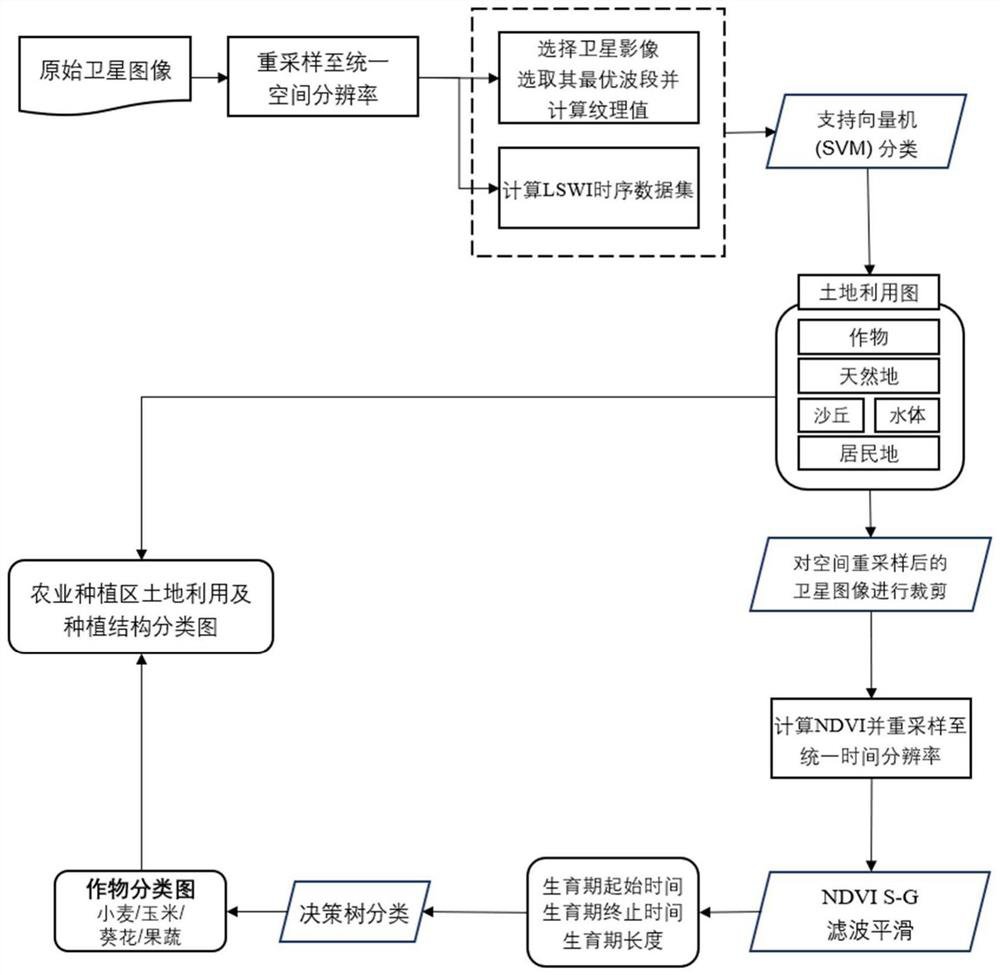
[0070] Manually select land use sample sets (residential land, sand dunes, wasteland, water bodies and farmland) from Google Earth.
[0073] Based on the vector data of the agricultural area, the original satellite images under the condition of clear sky and cloudless for many periods during the growth period are cropped,
[0074] Using the Savitzky-Golay (S-G) filter, the NDVI time series data set of the reproductive period is smoothed. Figure 5
Login to View More PUM
 Abstract
The invention belongs to the field of agricultural remote sensing, and relates to a remote sensing identification method for land cover and planting structure of a fragmented agricultural area, which adopts a machine learning algorithm to extract land utilization, does not depend on actually measured sample points, and obtains high-precision agricultural area land utilization rasterized data after automatic training. According to the method, an agricultural area and a non-agricultural area are classified through a supervision algorithm support vector machine (SVM), and then crop types are further classified and discriminated by adopting a decision tree algorithm based on obtained agricultural area classification raster data. The method does not depend on actual measurement data, classification time and economic cost are greatly reduced, and negative effects of the quality of a sample training set of a traditional machine algorithm on a classification result are effectively avoided. And meanwhile, the land utilization mapping precision required by agricultural remote sensing application is met on the premise of ensuring high classification efficiency.
Description
A remote sensing identification method for land cover and planting structure in finely fragmented agricultural areas technical field The invention belongs to the field of agricultural remote sensing, relate to a kind of remote sensing sensing of land cover and planting structure in a finely fragmented agricultural area Another method, using machine learning algorithm to extract land use, does not rely on measured sample points, and obtains high-precision agriculture after automatic training District land use rasterized data. Background technique Accurate and timely acquisition of land cover information in agricultural areas is useful for monitoring agricultural conditions, adjusting agricultural structure, estimating yield and formulating food grains. Food policies, etc. are of great significance. Traditional field investigation methods are time-consuming and labor-intensive, and it is difficult to obtain large-scale regional land interest. use information. Remote ...
Claims
Login to View More Application Information
Patent Timeline
 IPC IPC(8): G06V20/13G06V10/32G06V10/764G06K9/62G06T3/40G06N20/10
CPCG06T3/4007G06N20/10G06F18/2411
Inventor 徐旭李欣怡蒙慧敏黄权中黄冠华
Owner CHINA AGRI UNIV