Multi-beam underwater terrain combination matching method based on inertial constraints

A matching method and inertial constraint technology, applied in navigation, instrumentation, surveying and navigation, etc., can solve the problems of large influence of the initial inertial error of the ICCP algorithm, easy to fall into local optimal matching, and inability to reduce the cumulative error of inertial trajectory, etc., to achieve improved Accuracy and robustness, effect of improving positioning accuracy

Active Publication Date: 2022-08-02
SOUTHEAST UNIV
View PDF10 Cites 0 Cited by
  • Summary
  • Abstract
  • Description
  • Claims
  • Application Information

AI Technical Summary

Problems solved by technology

[0004] Purpose of the present invention: In order to overcome the deficiencies of the existing batch processing matching algorithm, effectively solve the problem that the ICCP algorithm is greatly affected by the initial inertia error, easily falls into local optimal matching and cannot reduce the cumulative error of the inertial trajectory, an...

Method used


Image

  • Multi-beam underwater terrain combination matching method based on inertial constraints
  • Multi-beam underwater terrain combination matching method based on inertial constraints
  • Multi-beam underwater terrain combination matching method based on inertial constraints

Examples


Embodiment 1

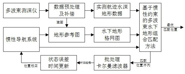
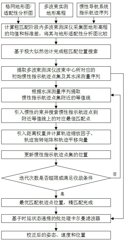
[0080] like figure 1 As shown, the underwater terrain-aided inertial navigation system is mainly composed of five parts: multi-beam echo sounder, inertial navigation system, underwater terrain grid map, matching algorithm and information fusion filter. The function of the multi-beam echo sounder is to measure the water depth and elevation value corresponding to the track point of the underwater vehicle in real time, which can be used as the terrain measurement value to be matched after data preprocessing and error compensation; Provide the navigation parameter information of the aircraft, and the data output update rate is high; the terrain reference map is a digital map of the area extracted from the computer according to the position indicated by the inertial navigation system, and its presentation form is a terrain elevation database stored in a two-dimensional array; matching The function of the algorithm is to match the measured terrain elevation value with the terrain re...


PUM


Abstract

The invention discloses a multi-beam underwater terrain combination matching method based on inertial constraints, which belongs to the field of terrain-assisted inertial navigation. The method of the present invention: firstly, based on the bathymetry sequence and the initial position provided by the inertial navigation system, using terrain adaptation parameters and maximum likelihood estimation to achieve fast rough matching; then, introducing inertial constraints and distance weights to reduce mismatched points The influence of , and an accurate numerical solution for calculating the trajectory scaling factor is given. The precision matching is achieved by sequentially scaling, rotating and translating the inertial indicated track; finally, the position sequence obtained by the two-step matching is compared with the inertial track The difference between the indicated position sequences of the navigation system is used as the observation value of the Kalman filter based on the time-delay error correction based on state recursion to correct the attitude, velocity and position of the inertial navigation system and improve the positioning accuracy of the integrated navigation.

Description

technical field [0001] The invention relates to a multi-beam underwater terrain combination matching method based on inertial constraints, and belongs to the field of terrain-assisted inertial navigation. Background technique [0002] The inertial navigation system is an autonomous navigation system that does not rely on any other external information, nor does it radiate energy outward. , which makes the underwater vehicle unable to achieve long-term deep-sea navigation. In order to control the positioning error range, the vehicle usually needs to float up regularly to receive satellite navigation signals and correct the navigation error, which leads to a decrease in the concealment of the vehicle and energy consumption. greatly increased. In the past ten years, due to the production of high-resolution grid topographic maps and the development of multi-beam bathymetry technology, it has become possible to use terrain features for assisted navigation. The combination of ter...

Claims


Application Information

Patent Timeline
IPC IPC(8): G01C21/00G01C21/16G01C21/20
CPCG01C21/005G01C21/165G01C21/188G01C21/203
Inventor 程向红丁鹏
Owner SOUTHEAST UNIV
Why Eureka
Try Eureka