Cloud top height real-time calculation method based on satellite infrared detection element parameters

A technology of real-time calculation and detection element, applied in the field of satellite detection, can solve the problems of difficult observation deviation, difficult application, less establishment, etc., and achieves the effect of high reliability and improved use efficiency.

Pending Publication Date: 2022-06-28
NAT SATELLITE METEOROLOGICAL CENT +3
View PDF0 Cites 3 Cited by
  • Summary
  • Abstract
  • Description
  • Claims
  • Application Information

AI Technical Summary

Problems solved by technology

The cloud removal method (Eyre and Watts, 1987; Li et al., 2005) assumes that only the cloud amount will change in the observations of adjacent fields of view, and the equivalent clear-sky radiation value of the target field of view can be obtained by combining observations of multiple fields of view, but Because this assumption is usually rarely established, it is difficult to be practically applied in numerical forecasting
The cloud mask auxiliary method (Li et al., 2004) considers that the high-resolution imager data can provide information such as cloud mask and cloud phase state, and can bring more cloud parameters to the hyperspectral infrared observation data to realize cloud detection , but based on the two-dimensional clear-sky field of view detection, the method is prone to too many observations that are not affected by clouds
Experience has shown that when satellite infrared hyperspectral channels have large noise or large deviations in pixel registration, which makes it difficult to handle observation deviations well, cloud pollution and hyperspectral detection data are difficult to integrate with clear sky data. data differentiation, making it difficult to practically apply in numerical forecasting

Method used


Image

  • Cloud top height real-time calculation method based on satellite infrared detection element parameters
  • Cloud top height real-time calculation method based on satellite infrared detection element parameters
  • Cloud top height real-time calculation method based on satellite infrared detection element parameters

Examples


Embodiment Construction

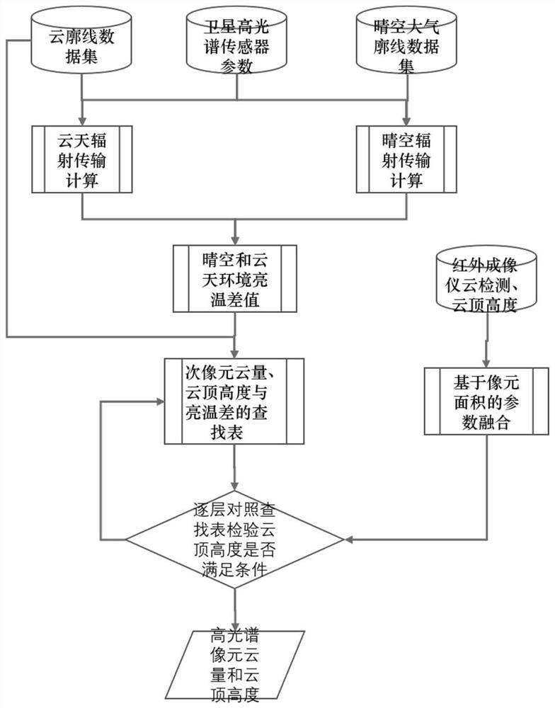
[0034] In order to make the purposes, technical solutions and advantages of the embodiments of the present invention clearer, the technical solutions in the embodiments of the present invention will be clearly and completely described below with reference to the accompanying drawings in the embodiments of the present invention. Obviously, the described embodiments These are some embodiments of the present invention, but not all of them. Based on the embodiments of the present invention, all other embodiments obtained by those of ordinary skill in the art without creative efforts shall fall within the protection scope of the present invention. Accordingly, the following detailed description of the embodiments of the invention provided in the accompanying drawings is not intended to limit the scope of the invention as claimed, but is merely representative of selected embodiments of the invention. Based on the embodiments of the present invention, all other embodiments obtained b...


PUM


Abstract

The invention discloses a cloud top height real-time calculation method based on satellite infrared detection element parameters, and the method comprises the steps: firstly collecting a cloud profile data set, satellite hyperspectral sensor parameters and a clear sky atmosphere profile data set, and carrying out cloud sky radiation transmission calculation and clear sky radiation transmission calculation on the data sets to obtain a clear sky environment brightness temperature difference value and a cloud sky environment brightness temperature difference value; calculating by combining the calculated bright temperature difference value of the clear sky and the cloud sky environment with the cloud profile data set to obtain a lookup table of the sub-pixel cloud cover, the cloud top height and the bright temperature difference; checking whether the cloud top height meets conditions or not by comparing the lookup table layer by layer; if yes, the cloud cover and the cloud top height of the hyperspectral pixel are obtained; and if not, continuing to execute the steps. The method is reliable in data calculation.

Description

technical field [0001] The invention relates to the technical field of satellite detection, in particular to a real-time calculation method of cloud top height based on satellite infrared detection element parameters. Background technique [0002] The assimilation of hyperspectral infrared detector data has become one of the main concerns of current research. Due to the inability of infrared radiation to penetrate the cloud layer, the satellite hyperspectral infrared atmospheric sounding data is subjected to cloud detection during assimilation to eliminate cloud-affected data. Observation is very important. For different hyperspectral infrared atmospheric detectors, many researchers have proposed a variety of cloud detection methods for hyperspectral infrared observation data through different methods. The clear sky field detection method based on Bayesian theory (English et al., 1999) can give the probability of no cloud in the observation field and can be used for various...

Claims


Application Information

Patent Timeline
Patent Type & Authority Applications(China)
IPC IPC(8): G06V20/00G06V10/143G01W1/00
CPCG01W1/00
Inventor 马刚闫旭升张鹏
Owner NAT SATELLITE METEOROLOGICAL CENT
Why Eureka
Try Eureka