Hydrogeological exploration method and device
A hydrogeological and geological technology, applied in the field of geological exploration, can solve the problems of low accuracy and availability of survey information, low exploration efficiency, time-consuming and labor-intensive problems, etc.
Pending Publication Date: 2022-07-12
深圳市地质局 +1
0 Cites 0 Cited by
AI-Extracted Technical Summary
Problems solved by technology
[0004] The object of the present invention is to provide a method and device for hydrogeological exploration, which is used to improve the prior art because people did not formulate an effective exploration plan for the complex environmental conditions of ...
Method used
[0111] In the above implementation process, the device obtains the existing geological information of the target exploration area from the preset database according to the range information of the target exploration area. According to the existing geological information of the target exploration area, a rough 3D geological information model and corresponding geological knowledge base of the target exploration area are established. The rough three-dimensional geological information model contains the existing geological information corresponding to each position of the target exploration area, and the existing geological information of each position of the target exploration area can be intuitively displayed through the rough three-dimensional geological information model. The geological information of the target exploration area can be analyzed through the geological knowledge base. According to the existing geological information, the distribution position of the first limestone layer is determined, wherein the first limestone layer is a limestone layer containing moisture. Based on the distribution position, drilling technology is used to explore any first limestone layer, and the exploration results are obtained. The exploration results include the current water flow and layer thickness of the first limestone layer, so as to obtain the specific data of the layer containing water. According to the distribution position of the first limestone layer, the current water flow and layer thickness of the first limestone layer are input to the corresponding position in the 3D geological information model for comparison, and the comparison data are obtained, and the 3D geology is updated using the current water flow and layer thickness The information model not only ensu...
Abstract
The invention provides a hydrogeological exploration method and device, and relates to the technical field of geological exploration. The method comprises the following steps: acquiring existing geological information of a target exploration area from a preset database; and establishing a rough three-dimensional geological information model of the target exploration area and a corresponding geological knowledge base. And determining the distribution position of the first limestone layer according to the existing geological information. And based on the distribution position, exploring any first limestone layer by using a drilling technology to obtain an exploration result. And inputting the current water flow and the layer thickness of the first limestone layer to corresponding positions in the three-dimensional geological information model for comparison to obtain comparison data. And inputting the exploration result of the first limestone layer, the comparison data and the existing geological information into a geological knowledge base, and determining a water flow change reason. And according to a water flow change reason, utilizing the updated three-dimensional geological information model to determine an exploration scheme of each position so as to complete exploration of the target exploration area. The purpose of making an exploration scheme for complex environmental conditions of a mining area is achieved.
Application Domain
General water supply conservationProspecting/detection of underground water +1
Technology Topic
PetrologyGeophysics +4
Image
Examples
- Experimental program(1)
Example Embodiment
[0059] Example
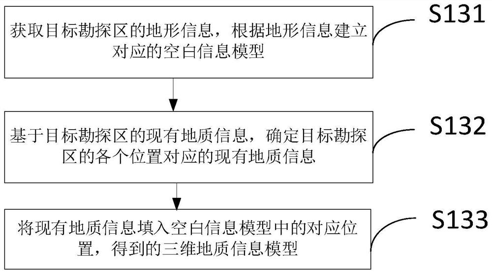
[0060] Please refer to figure 1 , figure 1 Shown is a flow chart of a hydrogeological exploration method provided by an embodiment of the present invention. The embodiment of the present application provides a hydrogeological exploration method, which includes the following steps:
[0061] S110: Obtain the scope information of the target exploration area;
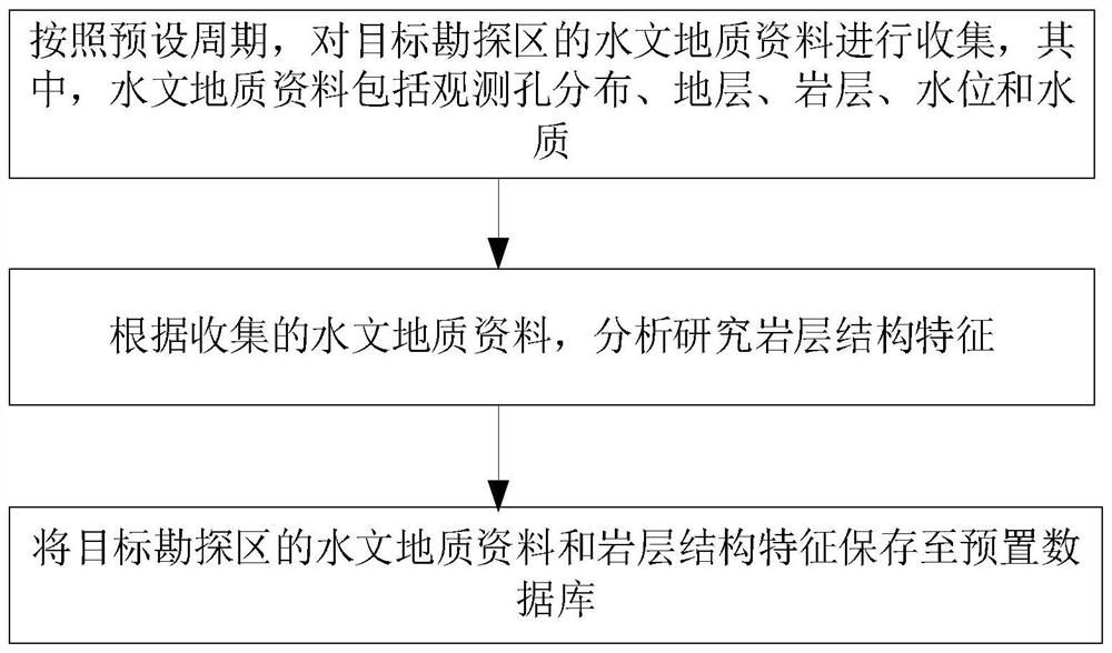
[0062] Specifically, the above-mentioned hydrogeology refers to various changes and movements of groundwater in nature. Hydrogeology mainly studies the distribution and formation rules of groundwater, the physical properties and chemical composition of groundwater, groundwater resources and their rational use, and the impact of groundwater on engineering Adverse effects of construction and mining and their prevention and control.
[0063] Wherein, the scope information of the target exploration area includes longitude and latitude information of the boundary of the target exploration area.
[0064] S120: According to the scope information, obtain the existing geological information of the target exploration area from the preset database;
[0065] Among them, the existing geological information of each region is pre-stored in the preset database.
[0066] Specifically, according to the scope information of the target exploration area, all existing geological information within the scope information is retrieved from the preset database.
[0067] S130: According to the existing geological information of the target exploration area, establish a rough three-dimensional geological information model of the target exploration area and a corresponding geological knowledge base;
[0068] Specifically, the rough three-dimensional geological information model includes the existing geological information corresponding to each position of the target exploration area, and the existing geological information of each position of the target exploration area can be visually displayed through the rough three-dimensional geological information model. The above-mentioned geological knowledge base is constructed by means of thesaurus and rule base, using existing geological information and existing geological knowledge, and the geological information of the target exploration area can be analyzed through the geological knowledge base.
[0069] S140: Determine the distribution position of the first limestone layer according to the existing geological information, wherein the first limestone layer is a limestone layer containing moisture;
[0070] Specifically, according to the existing geological information, the distribution positions of the first limestone layer and the second limestone layer are determined. The first limestone layer is a limestone layer containing moisture, and the second limestone layer is a limestone layer separating air and water flow. By effectively dividing the limestone's moisture-containing layers and the layers separating air and water flow, specific data on the moisture-containing layers can be identified.
[0071] S150: Based on the distribution position, use drilling technology to explore any first limestone layer to obtain an exploration result, where the exploration result includes the current water flow and layer thickness of the first limestone layer;
[0072] Specifically, since the first limestone layer is a limestone layer containing water, the geological measurement of the first limestone layer is carried out, and the water is extracted from the borehole by drilling technology, and then the amount of the extracted water and the thickness of the first limestone layer are analyzed. Calculations are made to obtain the current water flow and layer thickness of the first limestone layer.
[0073] S160: According to the distribution position of the first limestone layer, input the current water flow and layer thickness of the first limestone layer to the corresponding position in the three-dimensional geological information model for comparison, obtain comparison data, and update the current water flow and layer thickness at the same time 3D geological information model;
[0074] Specifically, according to the distribution position of the first limestone layer, the current water flow and layer thickness of the first limestone layer are compared one by one with the corresponding data in the three-dimensional geological information model, and the differences are found to obtain the comparison data. And use the current water flow and layer thickness to update the 3D geological information model to ensure that the updated 3D geological information model is consistent with the current hydrological address data in the target exploration area. The purpose of making full use of the existing geological information, the current water flow and layer thickness of the first limestone layer is achieved.
[0075] S170: Input the exploration results, comparison data and existing geological information of the first limestone layer into the geological knowledge base to determine the cause of the water flow change;
[0076] Specifically, the change of water flow in various regions has different manifestations due to changes in various factors. Through the geological knowledge base, the exploration results, comparison data and existing geological information of the first limestone layer can be analyzed to obtain the reasons for the change of water flow. . For example, if the water flow at the bottom of the fracture surface is prominent, the reason for the change in water flow is the composition and structure of the rock formation. For another example, if there is a protruding water flow at the bottom and it has a very destructive effect, the reason for the change in water flow is that people have changed the pressure when mining.
[0077] S180: According to the reasons for the change of the water flow, use the updated three-dimensional geological information model to determine the exploration plan for each location, so as to complete the exploration of the target exploration area.
[0078] Specifically, according to the reasons for the change of water flow, the exploration plan of each position in the target exploration area is determined, and the positions using the same exploration plan are delineated in the updated 3D geological information model, so as to facilitate the user to intuitively see the use of each position. Therefore, the purpose of formulating an effective exploration plan for the complex environmental conditions of the mining environment is realized. When the user conducts exploration according to the exploration plan defined by the 3D geological information model, because the exploration plan matches the geographical environment of the corresponding location, it not only effectively saves the user's exploration time, but also improves the exploration efficiency. Moreover, the method makes full use of the existing geological information, the current water flow rate and the layer thickness of the first limestone layer, and improves the availability of the data.
[0079] Please refer to figure 2 , figure 2 Shown is a flowchart of establishing a preset database according to an embodiment of the present invention. In some implementations of this embodiment, before the above step of acquiring the existing geological information of the target exploration area from the preset database according to the range information, the method further includes:
[0080] According to a preset period, the hydrogeological data of the target exploration area are collected, wherein the hydrogeological data includes the distribution of observation holes, strata, rock formations, water level and water quality;
[0081] According to the collected hydrogeological data, analyze and study the structural characteristics of rock formations;
[0082] Save the hydrogeological data and rock formation structure characteristics of the target exploration area to the preset database.
[0083] The preset period may be one month or two months.
[0084] In the above implementation process, the method periodically collects the distribution of observation holes, strata, rock layers, water level and water quality of the target exploration area according to a preset period, and uses these hydrogeological data to analyze and obtain rock layer structure characteristics. The hydrogeological data and rock formation structure characteristics are saved to the preset database, thus ensuring that the preset database contains all the existing geological information of the target exploration area.
[0085] In some implementations of this embodiment, the above-mentioned steps of analyzing and studying the structural characteristics of rock formations according to the collected hydrogeological data include:
[0086] According to the collected hydrogeological data, the dynamic characteristics of the water level of the rock layers of each aquifer are analyzed to determine the degree of water resource control under the rock layers of each aquifer.
[0087] In some implementations of this embodiment, the above-mentioned step of acquiring the scope information of the target exploration area includes:
[0088] Determine the area scope of the target exploration area in response to user operations;
[0089] According to the area scope of the target exploration area, determine the latitude and longitude information of the boundary of the target exploration area to obtain the scope information.
[0090] Specifically, the area scope of the target exploration area is determined according to the actual needs of the user, and the latitude and longitude information of the boundary of the area is obtained, and the latitude and longitude information of the boundary of the target exploration area is the scope information of the target exploration area.
[0091] Please refer to image 3 , image 3 Shown is a flow chart of establishing a three-dimensional geological information model provided by an embodiment of the present invention. In some implementations of this embodiment, the above-mentioned specific steps for establishing a rough three-dimensional geological information model of the target exploration area according to the existing geological information of the target exploration area are as follows:
[0092] S131: Obtain the terrain information of the target exploration area, and establish a corresponding blank information model according to the terrain information;
[0093] S132: Based on the existing geological information of the target exploration area, determine the existing geological information corresponding to each position of the target exploration area;
[0094] S133: Filling the existing geological information into the corresponding position in the blank information model to obtain a three-dimensional geological information model.
[0095] In the above implementation process, a blank information model matching the target exploration area is established based on the terrain information of the target exploration area, and then the existing geological information corresponding to each position is input into the blank information model to obtain a matching target exploration area. 3D geological information model, so as to achieve the purpose of establishing a 3D geological information model.
[0096] In some implementations of this embodiment, the above-mentioned steps of establishing a rough corresponding geological knowledge base of the target exploration area according to the existing geological information of the target exploration area include:
[0097] Based on the existing geological knowledge, a geological knowledge base of the target exploration area is established by using the existing geological information of the target exploration area, wherein the geological knowledge base is constructed by means of a thesaurus and a rule base.
[0098] Specifically, since the above-mentioned geological knowledge base is constructed by using the existing geological information and existing geological knowledge by means of thesaurus and rule base, the geological information of the target exploration area can be analyzed through the geological knowledge base.
[0099] In some implementations of this embodiment, the above-mentioned steps of inputting the exploration results, comparison data and existing geological information of the first limestone layer into the geological knowledge base, and determining the reasons for the change of water flow include:
[0100] If, according to the exploration results, comparative data and existing geological information of the first limestone layer, it is determined that the phenomenon of water flow change is that the bottom water flow protrudes at the fault layer, then the cause of the water flow change is the composition and structure of the rock layer.
[0101] Specifically, the phenomenon of water flow changes in various regions has different manifestations due to changes in various factors. For example, if the phenomenon of protruding water flow at the bottom of the fault layer occurs, the reason for the change of water flow is the composition and structure of the rock formation. For another example, if there is a protruding water flow at the bottom and it has a very destructive effect, the reason for the change in water flow is that people have changed the pressure when mining.
[0102] Please refer to Figure 4 , Figure 4 Shown is a structural block diagram of a hydrogeological exploration device 100 provided by an embodiment of the present invention. The embodiment of the present application provides a hydrogeological exploration device 100, which includes:
[0103] a scope information acquisition module 110, configured to acquire the scope information of the target exploration area;
[0104] The existing geological information acquisition module 120 is used for acquiring the existing geological information of the target exploration area from the preset database according to the scope information;
[0105] The model and knowledge base establishment module 130 is used for establishing a rough three-dimensional geological information model of the target exploration area and a corresponding geological knowledge base according to the existing geological information of the target exploration area;
[0106] The first limestone layer distribution position determination module 140 is configured to determine the distribution position of the first limestone layer according to the existing geological information, wherein the first limestone layer is a limestone layer containing moisture;
[0107] The first limestone layer exploration module 150 is configured to perform exploration on any first limestone layer by using drilling technology based on the distribution location, and obtain an exploration result, where the exploration result includes the current water flow and layer thickness of the first limestone layer;
[0108] The comparison module 160 is used for inputting the current water flow and layer thickness of the first limestone layer to the corresponding position in the three-dimensional geological information model according to the distribution position of the first limestone layer for comparison, to obtain comparison data, and at the same time using the current water flow rate and layer thickness. Flow and layer thickness update 3D geological information model;
[0109] The water flow change reason determination module 170 is used for inputting the exploration results, comparison data and existing geological information of the first limestone layer into the geological knowledge base to determine the water flow change reason;
[0110] The exploration plan determination module 180 is configured to use the updated three-dimensional geological information model to determine the exploration plan for each location according to the reasons for the change of the water flow, so as to complete the exploration of the target exploration area.
[0111] In the above implementation process, the device obtains the existing geological information of the target exploration area from the preset database according to the scope information of the target exploration area. According to the existing geological information of the target exploration area, a rough three-dimensional geological information model of the target exploration area and the corresponding geological knowledge base are established. The rough 3D geological information model contains the existing geological information corresponding to each position of the target exploration area. The rough 3D geological information model can intuitively show the existing geological information of each position of the target exploration area. The geological information of the target exploration area can be analyzed through the geological knowledge base. According to the existing geological information, the distribution position of the first limestone layer is determined, wherein the first limestone layer is a limestone layer containing moisture. Based on the distribution location, drilling technology is used to explore any first limestone layer, and exploration results are obtained. The exploration results include the current water flow and layer thickness of the first limestone layer, thereby obtaining specific data of layers containing moisture. According to the distribution position of the first limestone layer, the current water flow and layer thickness of the first limestone layer are input into the corresponding position in the 3D geological information model for comparison, and the comparison data is obtained. At the same time, the current water flow and layer thickness are used to update the three-dimensional geological information The information model not only ensures that the updated 3D geological information model is consistent with the current hydrological address data of the target exploration area, but also realizes the purpose of making full use of the existing geological information, the current water flow and layer thickness of the first limestone layer. Input the exploration results, comparison data and existing geological information of the first limestone layer into the geological knowledge base to determine the reasons for the change of water flow, thus realizing the exploration results, comparison data and existing geological information of the first limestone layer through the geological knowledge base. The information can be analyzed to obtain the purpose of the reasons for the change of water flow. According to the reasons for the change of water flow, the updated three-dimensional geological information model is used to determine the exploration plan of each location, so as to complete the exploration of the target exploration area. Through the updated 3D geological information model, it is convenient for users to intuitively see the exploration plan used at each location. The device achieves the purpose of formulating an effective exploration plan according to the complex environmental conditions of the mining area. When the user conducts exploration according to the exploration plan defined by the three-dimensional geological information model, since the exploration plan matches the geographical environment of the corresponding location, it not only effectively saves the user's exploration time, but also improves the exploration efficiency. Moreover, the device makes full use of the existing geological information, the current water flow rate and the layer thickness of the first limestone layer, and improves the availability of data.
[0112] Please refer to Figure 5 , Figure 5 This is a schematic structural block diagram of an electronic device provided in an embodiment of the present application. The electronic device includes a memory 101, a processor 102, and a communication interface 103. The memory 101, the processor 102, and the communication interface 103 are directly or indirectly electrically connected to each other to realize data transmission or interaction. For example, these elements may be electrically connected to each other through one or more communication buses or signal lines. The memory 101 can be used to store software programs and modules, such as program instructions/modules corresponding to a hydrogeological exploration device 100 provided in the embodiment of the present application, the processor 102 executes the software programs and modules stored in the memory 101 to execute Various functional applications and data processing. The communication interface 103 can be used for signaling or data communication with other node devices.
[0113] The memory 101 may be, but not limited to, random access memory (Random Access Memory, RAM), read only memory (Read Only Memory, ROM), programmable read only memory (Programmable Read-Only Memory, PROM), erasable memory Read-only memory (Erasable Programmable Read-Only Memory, EPROM), Electric Erasable Programmable Read-Only Memory (Electric Erasable Programmable Read-Only Memory, EEPROM), etc.
[0114] The processor 102 may be an integrated circuit chip with signal processing capability. The processor 102 may be a general-purpose processor, including a central processing unit (Central Processing Unit, CPU), a network processor (Network Processor, NP), etc.; it may also be a digital signal processor (Digital Signal Processing, DSP), an application-specific integrated circuit (Application Specific Integrated Circuit, ASIC), Field-Programmable Gate Array (Field-Programmable Gate Array, FPGA) or other programmable logic devices, discrete gate or transistor logic devices, and discrete hardware components.
[0115] understandably, Figure 5 The structure shown is only for illustration, and the electronic device may further include Figure 5 more or fewer components shown in, or have the same Figure 5 different configurations shown. Figure 5 The components shown in can be implemented in hardware, software, or a combination thereof.
PUM


Description & Claims & Application Information
We can also present the details of the Description, Claims and Application information to help users get a comprehensive understanding of the technical details of the patent, such as background art, summary of invention, brief description of drawings, description of embodiments, and other original content. On the other hand, users can also determine the specific scope of protection of the technology through the list of claims; as well as understand the changes in the life cycle of the technology with the presentation of the patent timeline. Login to view more.