Real-time three-dimensional geology modeling method based on GIS and virtual reality

A virtual reality, real-time three-dimensional technology, applied in 3D modeling, image data processing, instruments, etc., can solve problems such as long modeling cycle and complex data processing, reduce manual intervention, improve modeling efficiency, and improve practicability Effect

Inactive Publication Date: 2005-03-16
NANJING UNIV
View PDF0 Cites 14 Cited by
  • Summary
  • Abstract
  • Description
  • Claims
  • Application Information

AI Technical Summary

Problems solved by technology

This requirement is obviously unsatisfactory for methods with complex data processing and long modeling cycles.

Method used


Image

  • Real-time three-dimensional geology modeling method based on GIS and virtual reality
  • Real-time three-dimensional geology modeling method based on GIS and virtual reality
  • Real-time three-dimensional geology modeling method based on GIS and virtual reality

Examples


Embodiment Construction

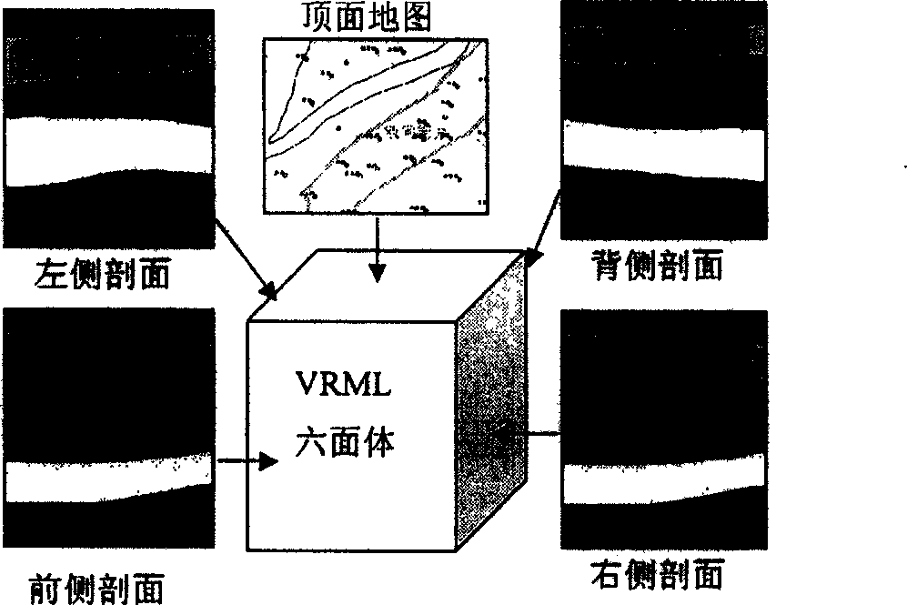
[0020] Such as figure 1 As shown, the basic idea of ​​3D geological modeling is to map on the surface of the hexahedron, especially the four sides and the top surface.

[0021] side map

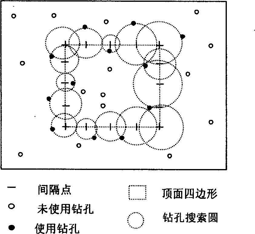
[0022] For efficiency in creating a section view, divide the four sides of the top quadrilateral equally (see figure 2 ), the specific number of equal divisions depends on the distribution density of the borehole data, so as to ensure that there is a borehole near each equal division point, and then perform spatial query in all the borehole data centered on the equal division point to find the distance, etc. Points to the nearest borehole. The data for that borehole is then "translated" to the bisection point. When the number and distribution of boreholes are permitted, the value at the equidistribution point can also be obtained through "interpolation". If there is information about the inclination and inclination angle of the rock formation in the drilling stratification data, the valu...


PUM


Abstract

The invention relates to a real time three-dimensional geology modeling method based on the GIS technique and the virtual realization technique. It pastes the picture on the surface of the hexahedron through the VRML. The pictures of the four sides are used to represent the lithologic character variation with the depth, and to construct the main body of the model. The top picture uses the two-dimensional map of the hexahedron located area, which comes from the two-dimensional GIS electric map. The graph processing of the bottom of the hexahedron is omitted. It is a new geology modeling method implemented with the VRML as the modeling instrument under the GIS conditions. The method uses the drilling data effectively without the complicated data processing.

Description

technical field [0001] The present invention relates to a method for three-dimensional geological modeling, especially a simplified method for developing real-time three-dimensional geological modeling based on GIS (Geographic Information System) data combined with virtual reality modeling language, which is used to realize fast and real-time three-dimensional geological modeling of geological bodies Modeling, using this method to carry out three-dimensional geological modeling of a research area. Background technique [0002] Since the geological body is formed through long-term and complex geological processes, it is a difficult problem to reproduce the geological body completely and truly. At present, the expression of geological bodies is mainly based on two-dimensional descriptions such as topographic maps, geological maps, cross-sections, and histograms. The development of computer technology has also made 3D geological modeling possible. The invention relates to thr...

Claims


Application Information

Patent Timeline
Patent Type & Authority Applications(China)
IPC IPC(8): G06T17/05G06T17/10
Inventor 王宝军施斌蔡奕周汇光索文斌
Owner NANJING UNIV
Why Eureka
Try Eureka