Network gridding service system of national geolopy spatial data

A spatial data and service system technology, applied in digital transmission systems, transmission systems, data processing applications, etc., can solve problems such as sharing difficulties, inability to maintain spatial data information, and lack of distributed databases, etc., to reduce system operating costs, Ease of deployment and management, and flexible architecture

Inactive Publication Date: 2006-04-19
DEV RES CENT OF CHINA GEOLOGICAL SURVEY
View PDF0 Cites 6 Cited by
  • Summary
  • Abstract
  • Description
  • Claims
  • Application Information

AI Technical Summary

Problems solved by technology

[0002] For a long time, my country has spent a lot of money to acquire various underground and surface resource data and information, and has accumulated a considerable scale of digital spatial information resources. According to preliminary estimates, my country's digital basic geological spatial information is about 1250GB, of which 40% The construction has been completed and put into independent operation service, and a series of independent data collection, comprehensive processing, and service standards have been formed. However, because the spatial and att

Method used


Image

  • Network gridding service system of national geolopy spatial data
  • Network gridding service system of national geolopy spatial data
  • Network gridding service system of national geolopy spatial data

Examples


Embodiment Construction

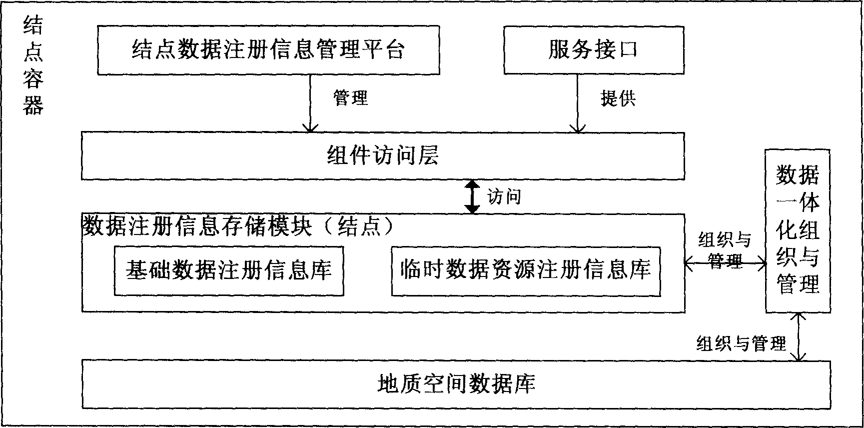
[0020] figure 1 The node container in the spatial data discovery unit shown includes: a data registration information storage module, a component access layer, a data integration organization and management module, a node data registration information management platform, a service interface, and a geological spatial database. The data registration information storage module includes: a basic data registration information database and a temporary data resource registration information database. The basic data registration information database is organized according to the third-generation geospatial data model (geodatabase model) and is organized according to the data The description method of the classification system is stored in the database through the data integration organization and management module; the temporary data resource registration information database is the data resource registration information that is dynamically generated and the results need to be saved. A...


PUM


Abstract

Structure of the system includes unit for finding spatial data, unit for asynchronous calling, load-balancing unit, fault-tolerance unit, unit of compression transmission and safe transmission, unit of safety authentication and userí»s authority etc. The unit for finding spatial data is divided to node container and door container for application. Unit for asynchronous calling sorts data information and calls the sorted data respectively. The load-balancing unit transfers data process to multiple servers to carry out jointly. Fault-tolerance unit manages service life cycle of Web service. The unit of compression transmission and safe transmission is in use for reducing network transmission flux and raising transmission efficiency. Unit of safety authentication and userí»s authority is in use for determining userí»s ID and authority etc. Advantages are: collecting and sharing special data resources geographical distributed, and synergistic treating requests of multiple data processed.

Description

Technical field [0001] The invention relates to the field of geological surveys, in particular to a national geological spatial data grid service system. Background technique [0002] For a long time, China has spent a lot of financial resources to obtain various underground and ground resource data and information, and has accumulated a considerable scale of digital spatial information resources. According to preliminary calculations, China's digital basic geological spatial information is about 1250 GB, of which 40% The construction has been completed and put into independent operation services, and a series of independent data collection, comprehensive processing, and service standards have been formed. However, because the space and attribute data in the spatial database are stored separately, the operation is isolated, which brings inconvenience to the application. Moreover, even zero-dimensional data is stored in small database systems such as ACCESS, DBASE, etc., which doe...

Claims


Application Information

Patent Timeline
IPC IPC(8): G06Q50/00H04L9/00G06F17/30G06Q50/10
Inventor 李超岭李丰丹罗显刚吕霞严光生谢忠薛群威杨东来陈荦
Owner DEV RES CENT OF CHINA GEOLOGICAL SURVEY
Why Eureka
Try Eureka