Method and system for determining the spatial position of a hand-held measuring appliance

A technology of space position and measuring instrument, which is applied in the direction of radio wave measuring system, measuring instrument, measuring device, etc., can solve the problems of complex determination of position and direction and inability to directly apply three-dimensional problems, so as to compensate for simple loss and reduce the number of reference points Effect

Inactive Publication Date: 2006-11-01
LEICA GEOSYSTEMS AG
View PDF8 Cites 16 Cited by
  • Summary
  • Abstract
  • Description
  • Claims
  • Application Information

AI Technical Summary

Problems solved by technology

[0012] However, since the motion is restricted to the plane, the determination of position and orientation here is not very complicated and cannot be directly ...

Method used


Image

  • Method and system for determining the spatial position of a hand-held measuring appliance
  • Method and system for determining the spatial position of a hand-held measuring appliance
  • Method and system for determining the spatial position of a hand-held measuring appliance

Examples


Embodiment Construction

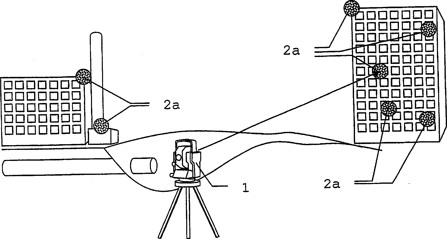
[0061] figure 1 The first step of the method according to the invention for positioning a construction machine is shown by way of example. By using the main station 1 as a geodetic measuring device, the reference points 2a placed on adjacent buildings on the construction site are measured and their spatial positions are determined. Establishing the reference point 2a at a high position allows good visibility and detectability from most positions on the construction site. The location of terminus 1 is known as the initial location of the method. However, in theory, other devices or methods can also be used to determine the position of the reference point 2a. In particular, the determination of the position of the reference point can also be carried out according to the invention with a locating device according to the invention in a known initial position. If there are points whose positions are known in any case, these points can be detected as reference points and used in ...


PUM


Abstract

The aim of the invention is to determine the actual position and/or actual orientation of a measuring appliance (4b). To this end, at least two reference points (2b') lying in a spatial segment (5') scanned by a laser beam are detected and measured in terms of the distance thereinbetween and the inclination angle thereof. The actual position of the measuring appliance (4b) can be deduced from the known positions of said reference points (2b') arranged in a detectable manner and the associated distances and inclination angle thereof. The detection, monitoring and measuring of the reference points is carried out by the measuring appliance (4b) in an automated manner, the measuring appliance (4b) and specifically embodied elements associated with the reference points (2b') forming a local positioning and/or orientation measuring system. The inventive method and corresponding devices enable measurements to be carried out in a problem-free and automated manner, even in areas that cannot be accessed by other measuring systems.

Description

technical field [0001] The invention relates to a method according to claim 1 for determining the spatial position of a hand-held measuring instrument, the use of the method according to claim 14 to correct deviations of inertial sensor-based positioning and orientation measuring devices, a A handheld measuring device according to the preamble of claim 15, a local position determination system according to claim 27 and the use of the method according to claim 29. Background technique [0002] In many geodetic applications, methods and systems for determining the position and / or orientation of geodetic instruments are used. From the position determined by such a system, further measurements associated with this position and usually also requiring knowledge of the spatial orientation of the measuring instrument are usually subsequently carried out. For this application, the 6 degrees of freedom of the handheld measuring instrument must be determined to unambiguously determine...

Claims


Application Information

Patent Timeline
IPC IPC(8): G01C15/00
CPCG01C15/002G01S17/06
Inventor 伯恩哈德·布劳内克伯恩哈德·盖西尔贝亚·埃比舍尔
Owner LEICA GEOSYSTEMS AG
Why Eureka
Try Eureka