Method of generating and organizing source data of grid electron map and method of generating target data

A technology of electronic map and grid map, which is applied in the fields of electrical digital data processing, special data processing applications, electrical components, etc.

Active Publication Date: 2007-05-30
TIANZE INFORMATION IND
View PDF1 Cites 32 Cited by
  • Summary
  • Abstract
  • Description
  • Claims
  • Application Information

AI Technical Summary

Problems solved by technology

[0013] The granularity of the map source segmentation in the above method is limited by the displa

Method used


Image

  • Method of generating and organizing source data of grid electron map and method of generating target data
  • Method of generating and organizing source data of grid electron map and method of generating target data
  • Method of generating and organizing source data of grid electron map and method of generating target data

Examples


Embodiment Construction

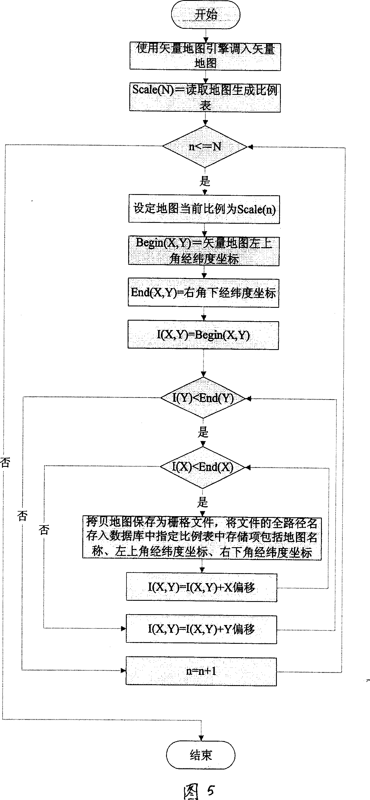
[0031] (1) Generation and organization of raster electronic map source data

[0032] Raster electronic map source data consists of multiple zoom ratios and multiple pictures, and is stored in a specified directory.

[0033] The database is used to store the relationship between the scale information, picture, picture name, and latitude and longitude range of the raster electronic map source data.

[0034] a) Database building requirements

[0035] Table name 1: Zoom

[0036] field name

Types of

primary key

illustrate

Zoom

number

no

TableName

the text

yes

[0037] Each row of data in the Zoom table represents a different image zoom ratio. Each ratio has a corresponding table in the database, and the table name is the same as the TableName in the Zoom table.

[0038] Table name 2: the content of the TableName field in the Zoom table

[0039] field name

Types of

primary key

illustrate ...


PUM


Abstract

A method for generating and organizing the source data of grid electronic map and generating the target data is disclosed, it can realize the map to match with the GP8 location information is finished on the sever, use the vector map and the engine of vector map to form the grid map file with various specification, the source data of grid map is generated, the grid map file uses the database and the file index to store the coordinate and the index of the grid map file, the target grid map specification requirement and the latitude and longitude information is transmitted by the HTTP\SOCKET\message mechanism, the map generating system will search the database or file to obtain the source data of grid map, and clip and splice to generate the target grid map and transmit to the target application; the vector map is called by the vector map engine, and read the present scale and the latitude and longitude information at the left upper corner or right upper corner; copy the map as the grip file, save the all path name of file containing the stored coordinate to the appointed store items in the scale table of the database array.

Description

technical field [0001] The invention relates to a method for dynamically making and expressing a grid map in a geographic information system (GIS). Especially the method of generating, organizing and generating target data of raster electronic map source data. Background technique [0002] Raster electronic maps are widely used in electronic map display on the WEB. It provides powerful engine support for map display on the Web for the characteristics of web interaction, concurrent access, and data flow restrictions. It can also be used for conventional maps that do not require high map updates. Application development. [0003] Electronic map (b / s structure) mainly includes two ways. One is vector and the other is raster. [0004] Vector mode: according to the spatial coordinate point data and mathematical formulas, the map is drawn through the local drive of the client. [0005] Grid mode: display the map in the form of pictures. [0006] Corresponding to the above two...

Claims


Application Information

Patent Timeline
IPC IPC(8): G06F17/30H04L29/06
Inventor 陈进薛扬周翔张向华翟省
Owner TIANZE INFORMATION IND
Why Eureka
Try Eureka