Fixing magnetometer based azimuth according to sun positioning

a technology of magnetometer and sun positioning, applied in the direction of instruments, measurements using magnetic resonance, surveying and navigation, etc., can solve the problems of significant challenges in providing absolute azimuth with respect to fixed reference, and achieve the effect of improving the accuracy of ahrs azimuth readings, preventing redundant computation and resource utilization, and improving image processing for identifying the center of the sun

Active Publication Date: 2020-03-17
GETZ ALON +1
View PDF7 Cites 0 Cited by
  • Summary
  • Abstract
  • Description
  • Claims
  • Application Information

AI Technical Summary

Benefits of technology

[0011]Calibrating sensor based azimuth according to the actual azimuth calculated based on an absolute positioning of the sun may significantly improve accuracy of the azimuth produced by the magnetometer sensors which may typically be inherently inaccurate as well as susceptible to a plurality of external disruptions (e.g. local magnetic fields, radiation, etc.) that may degrade their operation, performance and / or accuracy. As the sun positioning is absolute, adjusting azimuth obtained from the magnetometer sensors according to a real azimuth calculated based on the sun positioning may significantly improve the azimuth accuracy. The calibration may be done once and applied to subsequent azimuth readings from the magnetometer sensors.
[0018]In a further implementation form of the first and / or second aspects, the one or more magnetometer based inertial sensors are provided by an Attitude and Heading Reference system (AHRS). The true azimuth adjustment may be applied to existing AHRS systems which may be wide spread and used for a plurality of application to improve accuracy of the AHRS azimuth readings.
[0020]In a further implementation form of the first and / or second aspects, the code further comprises code instructions to convert the one or more images to a binary image in which each pixel in the one or more images is represented by one of two pixel values. The image processing for identifying the center of the sun may be significantly improved by using binary images in which light regions (pixels) may be easily distinguishable.

Problems solved by technology

While acquiring a relative orientation data, in particular azimuth may typically be straight forward, providing an absolute azimuth with respect to a fixed reference may present significant challenges.

Method used


Image

  • Fixing magnetometer based azimuth according to sun positioning
  • Fixing magnetometer based azimuth according to sun positioning

Examples


Embodiment Construction

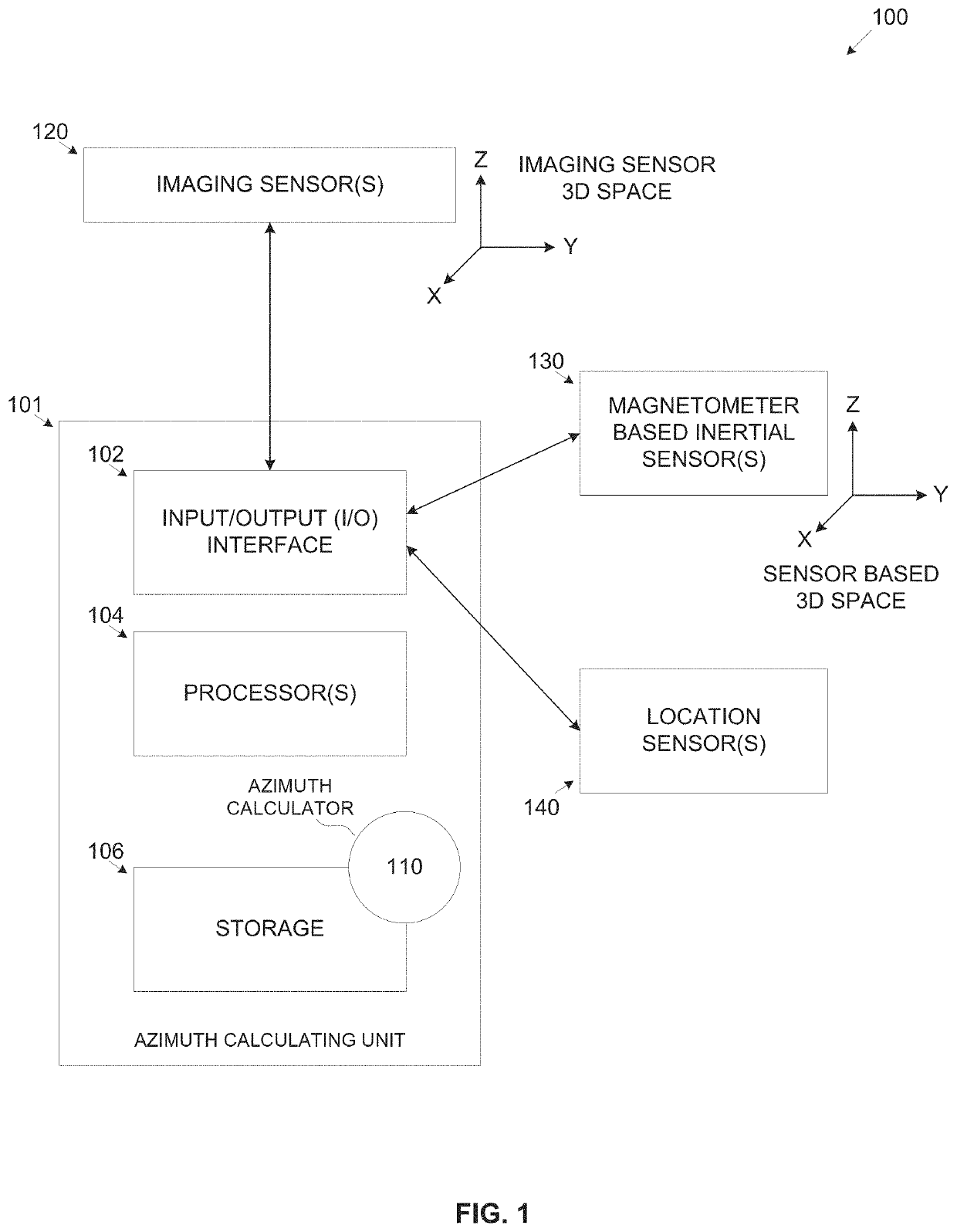
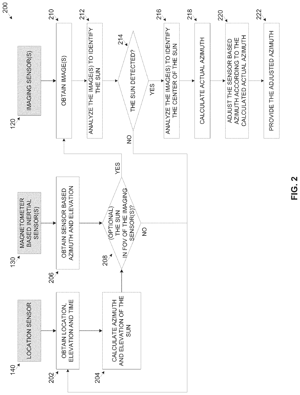
[0033]The present invention, in some embodiments thereof, relates to adjusting a sensor based azimuth provided by a magnetometer based inertial sensor and, more particularly, but not exclusively, to adjusting a sensor based azimuth provided by a magnetometer based inertial sensor according to position of the sun.

[0034]According to some embodiments of the present invention, there are provided methods, systems and computer program products for adjusting a sensor based azimuth obtained from one or more magnetometer based inertial sensors according to an actual azimuth calculated according to a current location, elevation and time with respect to an absolute position of the sun identified by analyzing one or more images captured by one or more imaging sensor(s).

[0035]The magnetometer based inertial sensor(s), for example, an accelerometer, a gyroscope, an IMU, an AHRS and / or the like provide azimuth, orientation, movement, and / or position information (readings). Based on information pro...


PUM


Abstract

A system for improving azimuth accuracy of a Line Of Sight (LOS) by adjusting an azimuth value obtained from one or more magnetometer based inertial sensors according to the sun position, comprising one or more magnetometer based inertial sensors, one or more imaging sensors, one or more location sensors and one or more processors coupled to the sensors. The processor(s) is adapted to execute a code comprising code instructions to: obtain location, elevation and time from the location sensor(s), obtain a sensor based azimuth value of a LOS of the imaging sensor(s) from the magnetometer based inertial sensor(s), obtain image(s) depicting the sun captured by the imaging sensor(s), calculate an actual azimuth value of the LOS according to the location, elevation and time with respect to a center of the sun computed by analyzing the image(s) and adjust automatically the sensor based azimuth value according to the actual azimuth value.

Description

RELATED APPLICATIONS[0001]This application claims the benefit of priority under 35 USC § 119(e) of U.S. Provisional Patent Application No. 62 / 492,316, filed on May 1, 2017. The contents of the above applications are all incorporated by reference as if fully set forth herein in their entirety.FIELD AND BACKGROUND OF THE INVENTION[0002]The present invention, in some embodiments thereof, relates to adjusting a sensor based azimuth provided by a magnetometer based inertial sensor and, more particularly, but not exclusively, to adjusting a sensor based azimuth provided by a magnetometer based inertial sensor according to position of the sun.[0003]Acquiring an accurate azimuth may be essential for a plurality of applications, for example, navigation systems, aircrafts and / or vessels Attitude and Heading Reference Systems (AHRS), Augmented Reality applications and / or the like.[0004]While acquiring a relative orientation data, in particular azimuth may typically be straight forward, providi...

Claims


Application Information

Patent Timeline
Patent Type & Authority Patents(United States)
IPC IPC(8): G01C17/38G01R33/028G01R33/26
CPCG01C17/38G01R33/028G01R33/26
Inventor GETZ, ALONROGALSKY, AVIRABINOVICH, SAMUEL ALEXANDER
Owner GETZ ALON
Why Eureka
Try Eureka