
Determining a region of impact of an aircraft in the event of an emergency

a technology of aircraft impact and emergency, applied in the field of aviation, can solve the problems of general uncertainty of weather data and unknown extent of uncertainty, and achieve the effect of improving the forecast of aircraft behaviour

Active Publication Date: 2022-04-12
AALTO HAPS LTD
View PDF4 Cites 0 Cited by
  • Summary
  • Abstract
  • Description
  • Claims
  • Application Information

AI Technical Summary

Benefits of technology

[0016]The model of the aircraft may also be updated if by way of example the operating parameters of the aircraft (in particular the structural state) change. This updated model may then be used for an improved estimation of the falling behaviour (and resulting therefrom the region of impact) with less uncertainty.
[0034]The device described here comprises significant advantages even for such aircraft and the mentioned flight altitudes. Owing to the flight altitude and the relatively low fall speed of temporarily clearly below 10 m / s or even below 5 m / s there remains sufficient warning time with the result that the continuous monitoring of the aircraft in connection with the weather data and also the weather forecast and its uncertainty provides a good contribution for the operational safety when operating the aircraft. It is likewise conceivable that the device described herein is used in order to determine an aircraft position in which a descent of the aircraft is deliberately introduced. In taking into consideration the weather data and also the weather uncertainty, it is possible to select the corresponding aircraft position for the deliberately introduced descent with the result that the point of impact lies in a desired region of the surface of the Earth.
[0050]In other words, one aspect of the present disclosure may be described as follows: the device described herein for determining the region of impact of the aircraft uses parameters relating to the aircraft and / or elements on board the aircraft and also weather data and forecasts in order to forecast the behaviour of the aircraft during a movement in the direction of the surface of the Earth. The parameters relating to the aircraft and / or elements on board the aircraft may be on the one hand predetermined parameters or parameters that may be predetermined and on the other hand may be parameters that are currently ascertained by sensors, said parameters relating to the aircraft and / or elements on board the aircraft, and also combinations of these two types of parameters. The state of the aircraft and components of said aircraft may be monitored in that state information is ascertained continuously or in predetermined time intervals and is transmitted to the device in order then to be used for the procedure for determining a possible or probable region of impact. This state information may be applied to the digital model of the aircraft. The behaviour of the digital model may be forecast continuously or in time intervals. These forecasts of the behaviour of the digital model may then be compared with the behaviour of the aircraft. Deviations between the two may be used in order to adapt the parameters of the digital model with the result that the forecasts by means of the digital model are closer to the behaviour of the real aircraft. In other words, an iterative approach is implemented which renders possible an improved forecast of the behaviour of an aircraft.

Problems solved by technology

Weather data of a weather forecast generally suffers from a specific uncertainty, wherein the extent of the uncertainty is also unknown.

Method used


Image

  • Determining a region of impact of an aircraft in the event of an emergency
  • Determining a region of impact of an aircraft in the event of an emergency

Examples


Embodiment Construction

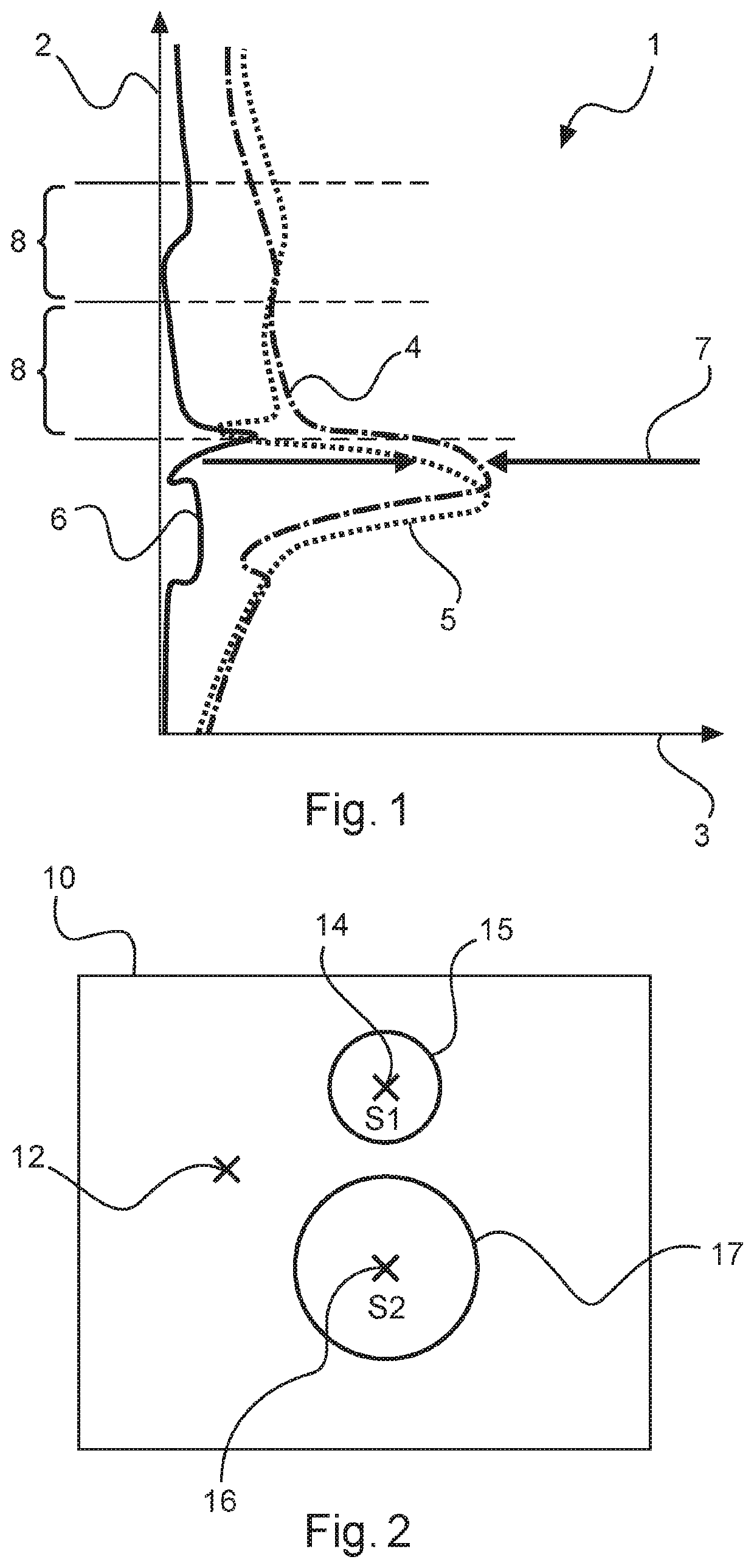
[0056]FIG. 1 illustrates an exemplary weather data diagram 1. The altitude above the surface of the Earth is plotted on the vertical axis 2 and the wind speed is plotted on the horizontal axis 3.

[0057]Such a weather data diagram 1 may be generated respectively for air movements in the north-south direction and in the east-west direction. In this case, the wind speed may assume positive or negative values. By way of example, positive values mean a wind movement towards the north or east whereas negative values mean a wind movement towards the south or west.

[0058]The altitude may be divided into multiple altitude positions 8 in order to be able to draw upon these altitude positions individually in order to determine the influence on a falling aircraft.

[0059]The line 4 that is illustrated as a dashed-dotted line corresponds to the retrieved weather information or the weather forecast for a specific point in time. The dotted line 5 corresponds to the actual weather situation as has been...


PUM


Abstract

A device for determining a region of impact of an aircraft on the surface of the Earth in the event of an emergency is configured to compare weather forecasts from the past with the weather conditions that are actually occurring and to determine therefrom an uncertainty of the weather forecasts using statistical means. This uncertainty of the weather forecasts is used in addition to position data and state information of the aircraft in order to determine a probable region of impact of the aircraft.

Description

FIELD OF THE INVENTION[0001]The present description relates in general to the technical field of aviation. In particular, the description relates to a device for determining the region of impact of an aircraft on the surface of the Earth in the event of an emergency. Furthermore, the description relates to a system or a combination of such a device and an aircraft, in particular an aircraft that is unmanned and that flies at high altitude.BACKGROUND OF THE INVENTION[0002]Aircraft are fundamentally subject to strict safety requirements. These safety requirements relate both to the operation of the aircraft as such as well as also the surrounding area of the aircraft including possible effects of the aircraft on the surface of the Earth.[0003]In order to achieve and / or to prove a specific degree of operational safety, an aircraft and its components may be tested prior to use with regard to operational safety and / or probability of failure. The probability of failure of the entire syste...

Claims


Application Information

Patent Timeline
Patent Type & Authority Patents(United States)
IPC IPC(8): G08G5/00B64F5/60B64C39/02
CPCG08G5/0013B64F5/60B64C39/024B64D45/04B64U10/00
Inventor KLÜSSENDORF, FABIANSTEVENS, PAULTATE, STEVE
Owner AALTO HAPS LTD
Learn More