Network-based method and system for determining a location of user equipment in CDMA networks

a network and user equipment technology, applied in direction finders using radio waves, navigation instruments, instruments, etc., can solve the problems of reducing the efficiency of the system, adding bulk and cost to the ue, and geographic location based on the rtt using the nominal transmission timing delay t.sub.0 can be significantly inaccura

Inactive Publication Date: 2002-07-18
NOKIA NETWORKS OY +1
View PDF12 Cites 80 Cited by
  • Summary
  • Abstract
  • Description
  • Claims
  • Application Information

AI Technical Summary

Problems solved by technology

The determination of the RTD for both the TOA and OTDOA methods of LCS is complex and therefore reduces the efficiency of the system.
This requirement thus adds both bulk and cost to the UE.
Accordingly, a geographic location based on the RTT using the nominal transmission timing delay T.sub.0 can be significantly inaccurate (the maximum inaccuracy in a location is typically greater than a cell radius).
If the transmission timing delay is assumed to be the default value T.sub.0, the actual transmission timing delay may be different, which results in the calculated distance being either too large or too small.

Method used


Image

  • Network-based method and system for determining a location of user equipment in CDMA networks
  • Network-based method and system for determining a location of user equipment in CDMA networks
  • Network-based method and system for determining a location of user equipment in CDMA networks

Examples


Embodiment Construction

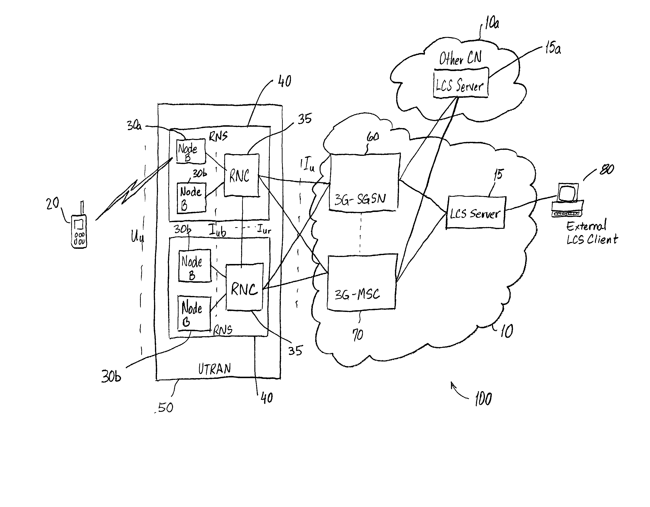
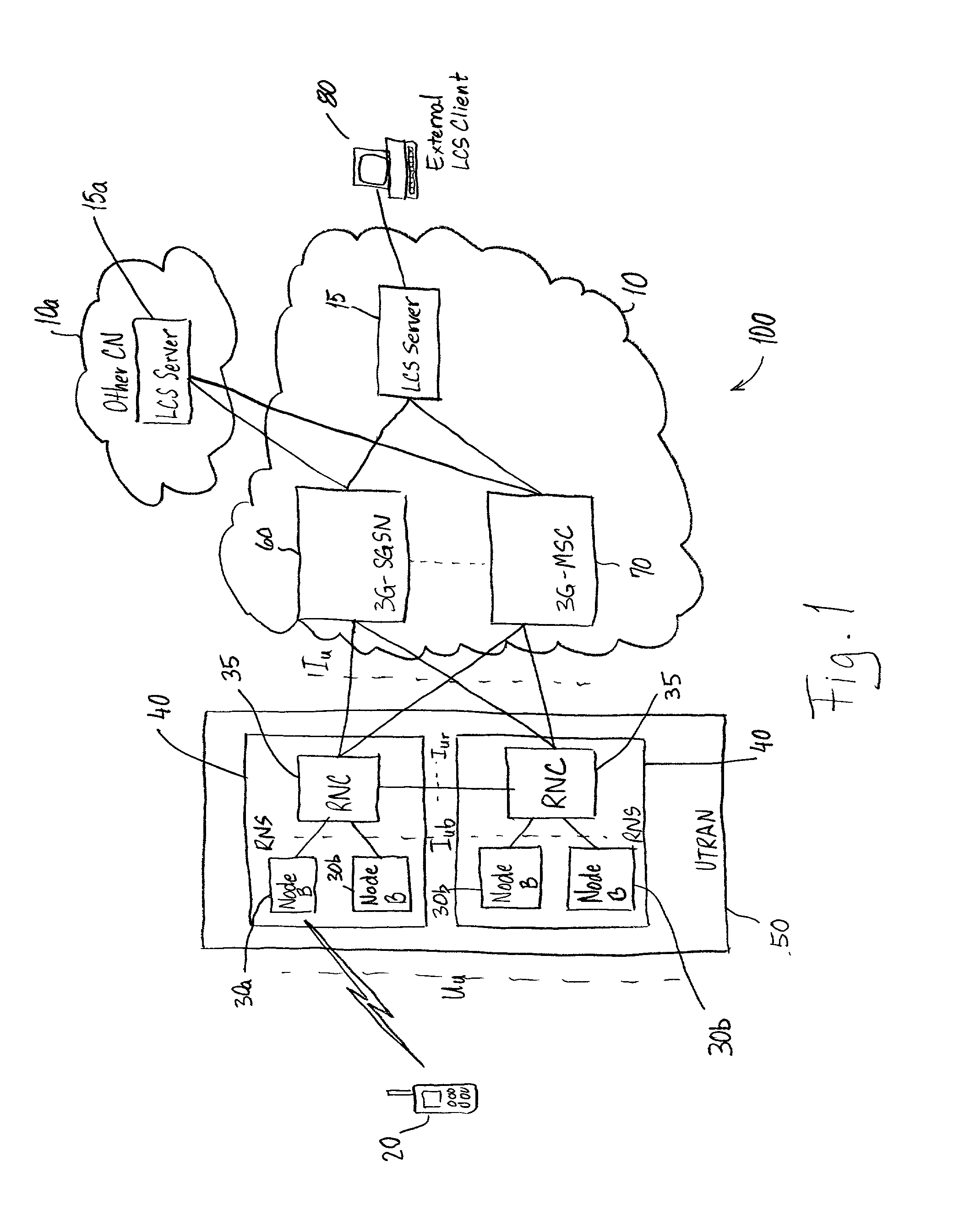
[0029] A Third Generation (3G) mobile communication system 100 for performing the method according to the present invention is shown in FIG. 1. The 3G mobile communication system 100 comprises a Core Network (CN) 10 with a LoCation Service (LCS) server 15 for providing location information about a User Equipment (UE) 20 within the geographical area covered by the CN 10. The UE 20 is a mobile equipment with one or several Universal Mobile Telephone System (UMTS) Subscriber Identity Module(s). The UE 20 may comprise a mobile phone, person digital assistant (PDA), a wearable computer, a device based on WAP technology, or any other mobile device capable of wireless communication. A plurality of Radio Network Subsystems (RNSs) 40 are operatively connected with the CN 10. Each RNS 40 comprises a plurality of transceiver nodes 30a, 30b. Each transceiver node 30 comprises a node-B, which is a logical node for radio communication with the UE 20 in one or more cells within a geographical tran...


PUM


Abstract

A method and system for determining a location of a user equipment using RTT measurements from a connected node B and RTT measurement of other node Bs which are not connected to the user equipment. The radio network controller of a network measures RTT of a connected node Bs and then measures RTT of non connected node Bs. Based on the RTT measurement, the distances of the user equipment from each node B is determined. Circles having radii equal to the distances of the user equipment from the nodes are used to determine the user equipment location.

Description

[0001] 1. Field of the Invention[0002] The present invention relates to determination of a location of user equipment in a third generation wideband code division multiple access network.[0003] 2. Description of the Related Art[0004] Third Generation (3G) mobile communication systems include LoCation Services (LCSs) which measure radio signals to determine the geographic location of a User Equipment (UE). The location information may be requested by and reported to a client and / or application associated with the UE or an external client in the Core Network (CN) of the 3G mobile communication system. Furthermore, the location information is also used by the Universal Terrestrial Radio Access Network (UTRAN) of the 3G mobile communication system to facilitate location assisted handovers or to support other features, such as home location billing.[0005] The LCSs for 3G mobile communication systems are based on methods that have been used for the Global System for Mobile Communication (...

Claims


Application Information

Patent Timeline
Patent Type & Authority Applications(United States)
IPC IPC(8): G01S5/00G01S5/12G01S5/14G01S19/48G01S19/49H04W64/00
CPCG01S5/0054G01S5/12G01S5/14G01S2205/008H04W64/00G01S2013/466
Inventor KERANEN, YRJOVIERO, TIMO
Owner NOKIA NETWORKS OY
Why Eureka
Try Eureka