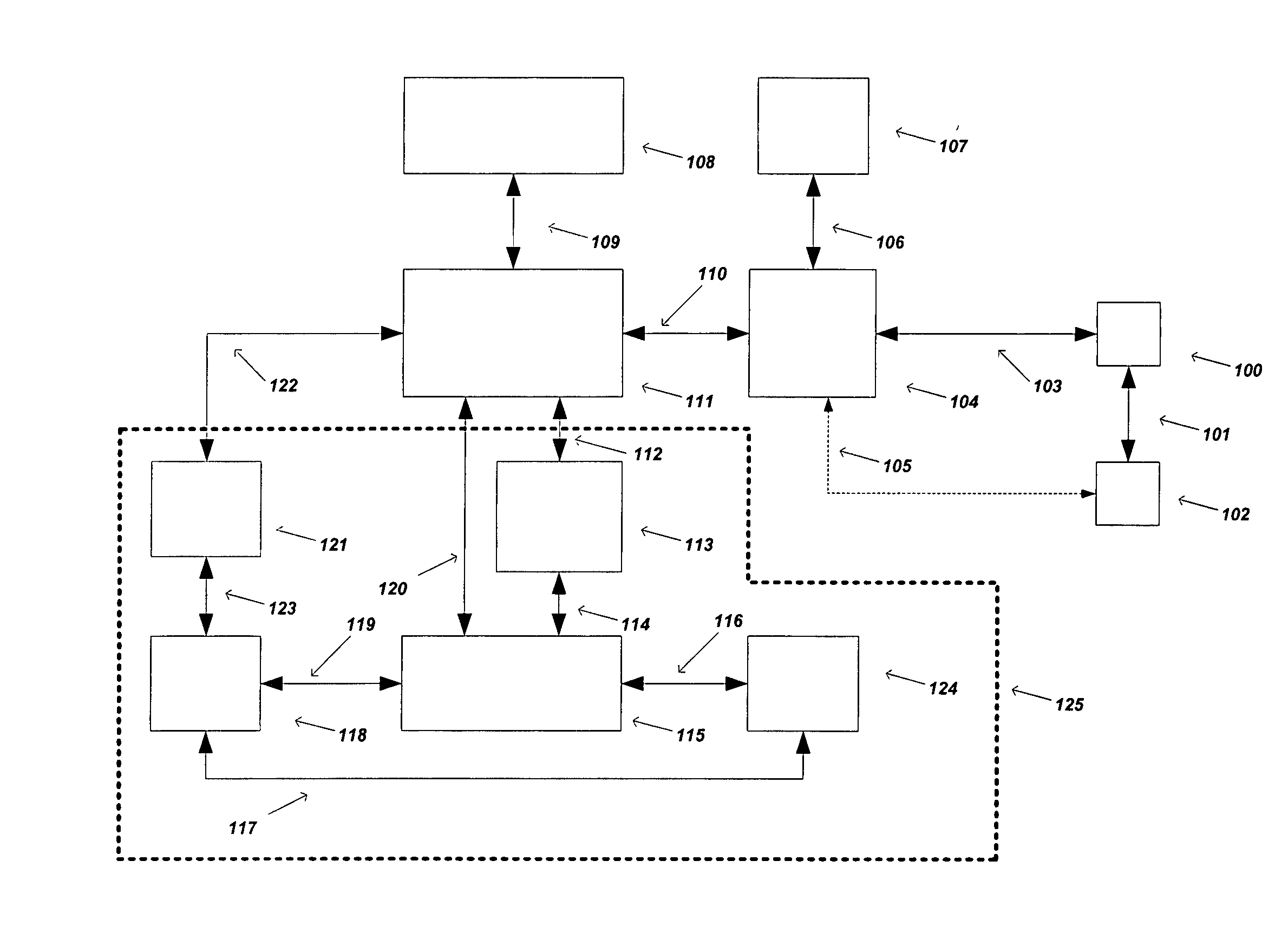
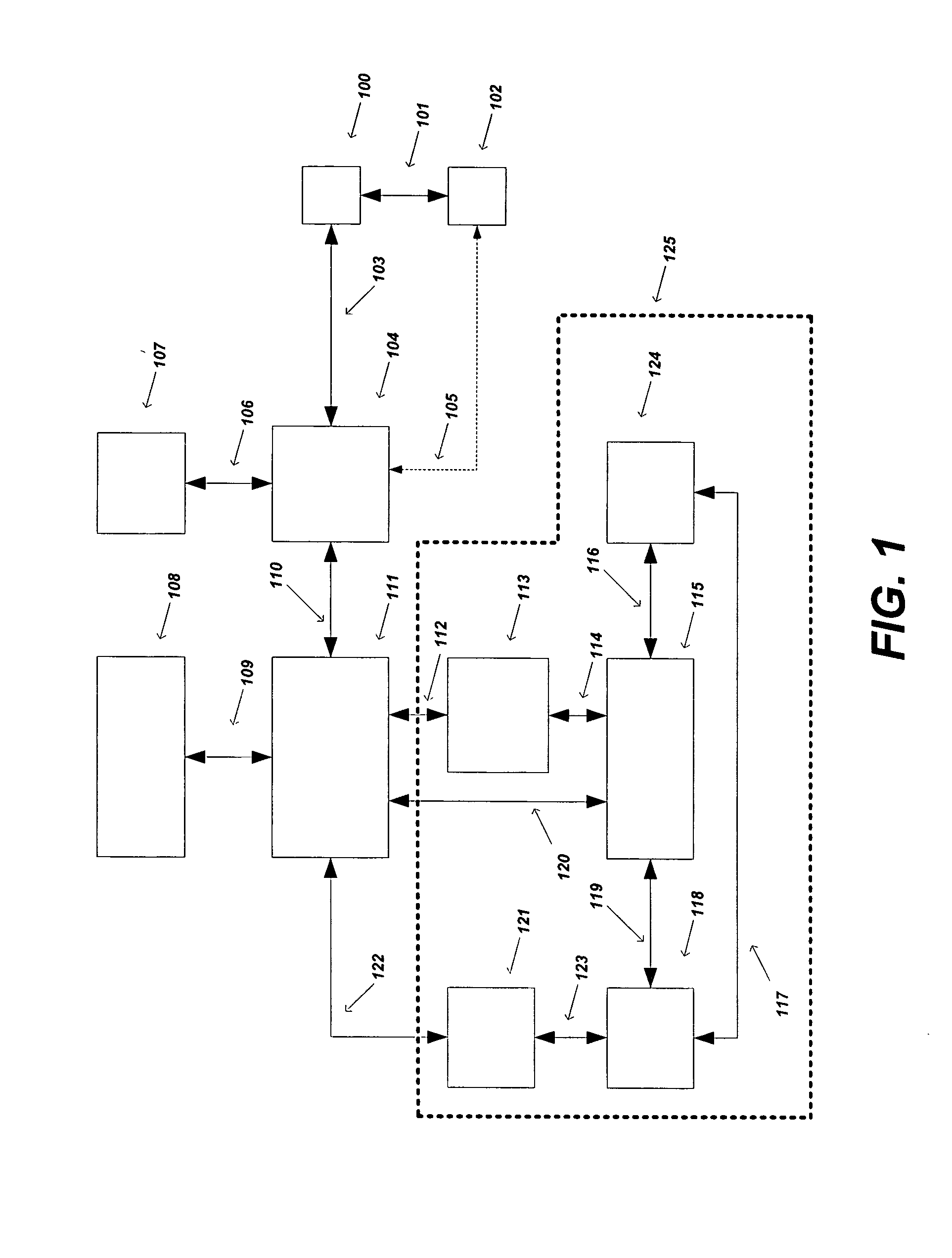
[0023] It is an object of the present invention to provide a method and
system for providing the capability of reducing ‘redundant’ location information or summarizing ‘detailed’ location information using a
graphical display in combination with a common thread, such as presence information,
user information,
temporal information, calendar information, or the like, in conjuncture with a
graphical display for either a single or plurality of users and / or devices without reducing the total information content of the data. Detailed location history, redundant or unique, from a visual standpoint, can be overwhelming and not entirely useful when displayed either graphically or in a textual context.
[0025] Displaying a summary of the number of location points for a specific range of time or in groups of location points in either a Calendar or
Gantt chart view, can provide a powerful way to visualize the important Meta data, such as stop locations, images, messages, etc., without obfuscating or concealing the actual information contained within the
time range of desired information. This invention provides the capability to display the summary details of Meta data, such as location information, to the user without reducing the total information content to the user. In many ways the total information content to the user is increased, since the user can better utilize and understand the overall data. The extraneous or redundant Meta data can reside on a local storage device and / or remotely on either a
server storage device (i.e.,
client-to-
server configuration) or remotely on another
client storage device (i.e., peer-to-peer configuration). In one embodiment, for a given presence range, a user collected 1000 location points, had 5 stop events, and took 3 images with a
digital camera. The high-level Meta data associated and displayed in either a calendar view or Gantt view would be the start and end of the presence events and their respected location points, the 5 stop events and 3 images in addition to their respected location points (i.e., a total of 10 location points including the presence events). The detailed 1000 location points need not be displayed initially, but only the summary of its information, such as the total number of location points collected, are displayed since a high degree of the useful information conveyed can be illustrated with the high-level Meta data (i.e., presence events, stops, images, and respective location points).
[0028] It is another object of the present invention to provide a method and
system for providing a
graphical display of
summary information summarizing detailed location and / or Meta data for a
specific time period or for a provided common thread that indirectly references a time period, such as presence information that is associated with said location and / or Meta data, for either a single or plurality of users and / or devices. In one embodiment, a stop event or presence event indirectly references a time period that provides an indirect thread for referencing a selection of Meta data. In another embodiment, in a Calendar view, selecting a day or group of days can indirectly reference a selection of Meta data, associated for a user / device or group of users / devices, that are contained within the selected time period. In another embodiment, the summarized location Meta data, such as “stops”, will also display, when available, the nearby Point of Interest (POI) (i.e., restaurants, schools, parks), geographical areas, user
contact list, or the like, that the location Meta data was nearest, thus providing a more detailed report of the recorded Meta data.
[0029] It is another object of the present invention to provide a method and system for providing the capability of sending, saving to a file, e-mailing, or the like, location and / or Meta data to a single or plurality of users using a common thread, such as presence information,
user information,
temporal information, calendar information, or the like, using a graphical display, such as a Calendar or
Gantt chart view. By sending this common thread to a single or plurality of users, the sender grants the recipients the same or
limited access (“use rights”), such as for a specified or
unlimited time period, to information associated with this common thread. The actual information content need not be all transferred at once, since only the common thread and accompanying
security information are necessary to provide access to all of the Meta
data content associated with said common thread. This associated Meta data can be stored either on the
server (i.e., any device other than the originating
client that can serve the information to the recipients) or on the originating client for later access and retrieval, based on the common thread sent to the recipients and the use rights associated with the transfer. The use rights associated with the transfer can limit the time allowed for the recipients to view the Meta data, or provide the sending party the ability to revoke the granted access at any given time. In another embodiment, a user would save a presence thread to a file that references various Meta data on a server. The user would then e-mail the said file to another user. This action is similar to sending the file directly to the destination user.
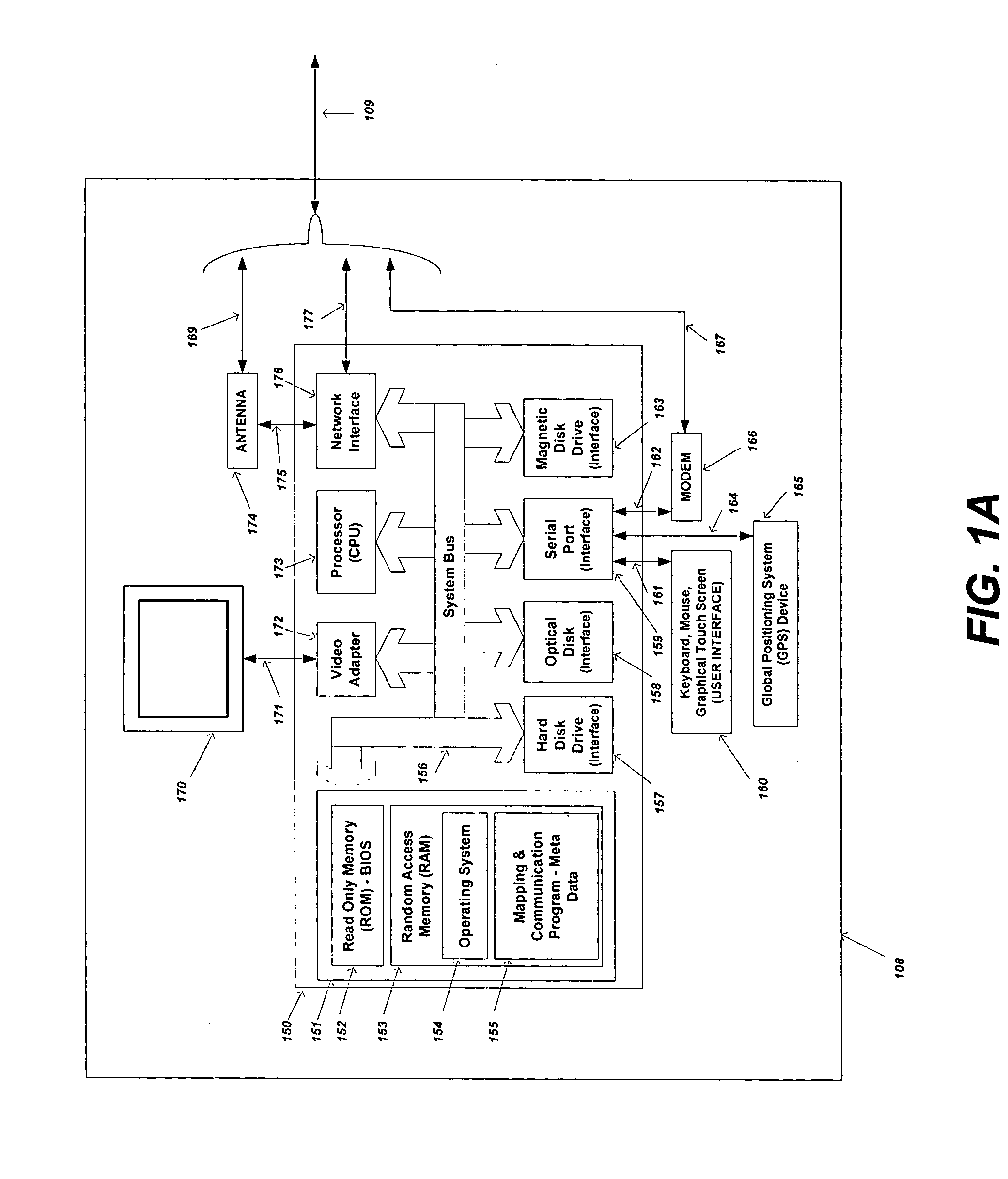
[0032] It is yet another object of the present invention to provide a method and system for providing the ability to synchronize location and / or Meta data using a common thread, such as presence information,
user information,
temporal information, calendar information, or the like, for either a single or plurality of users and / or devices, from an online server to a local or
remote computing device. This information is originally stored on a server that is connected to
the Internet,
Intranet, or
Extranet, and accessible by the end client, either via a wired or
wireless connection to
the Internet,
Intranet, or
Extranet, for the purpose of
synchronizing a subset or the entire set of location and / or Meta data. This allows the mirroring of the location and / or Meta data stored on the server onto to the local or
remote computing device. The data can be removed or left intact on the originating server after the synchronization process has been completed.

