Method and apparatus for map matching

a mapping method and map matching technology, applied in navigation instruments, traffic control systems, instruments, etc., can solve problems such as wrong gradient determination, wrong map matching processing, and vehicle position estimation to deviate from a road or route, so as to avoid wrong map matching processing

Active Publication Date: 2006-04-13
ALPINE ELECTRONICS INC
View PDF5 Cites 22 Cited by
  • Summary
  • Abstract
  • Description
  • Claims
  • Application Information

AI Technical Summary

Benefits of technology

[0027] In view of the foregoing problems, the present invention has an object to determine correctly that a vehicle is traveling a downgrade or upgrade link without being influenced by a swing back effect due to the start or stop of the vehicle so as to avoid wrong map matching processing.

Problems solved by technology

In the autonomous navigation method, however, error accumulates over the course of the vehicle travel to cause the estimated vehicle position to deviate from a road or route.
This causes the wrong determination of gradient when the acceleration outputted from the acceleration sensor is verified against the gradient information stored in the map database.
In the prior art, a road link sloping gently over a long distance with an inclination angle of the set angle or less cannot be judged correctly as an upgrade link or a downgrade link, which may lead to the wrong map matching processing.
Additionally, in the prior art, a road link including a steep slant and a flat part following the slant have not been judged correctly as the downgrade or upgrade link.
This disadvantageously results in the wrong map matching.

Method used


Image

  • Method and apparatus for map matching
  • Method and apparatus for map matching
  • Method and apparatus for map matching

Examples


Embodiment Construction

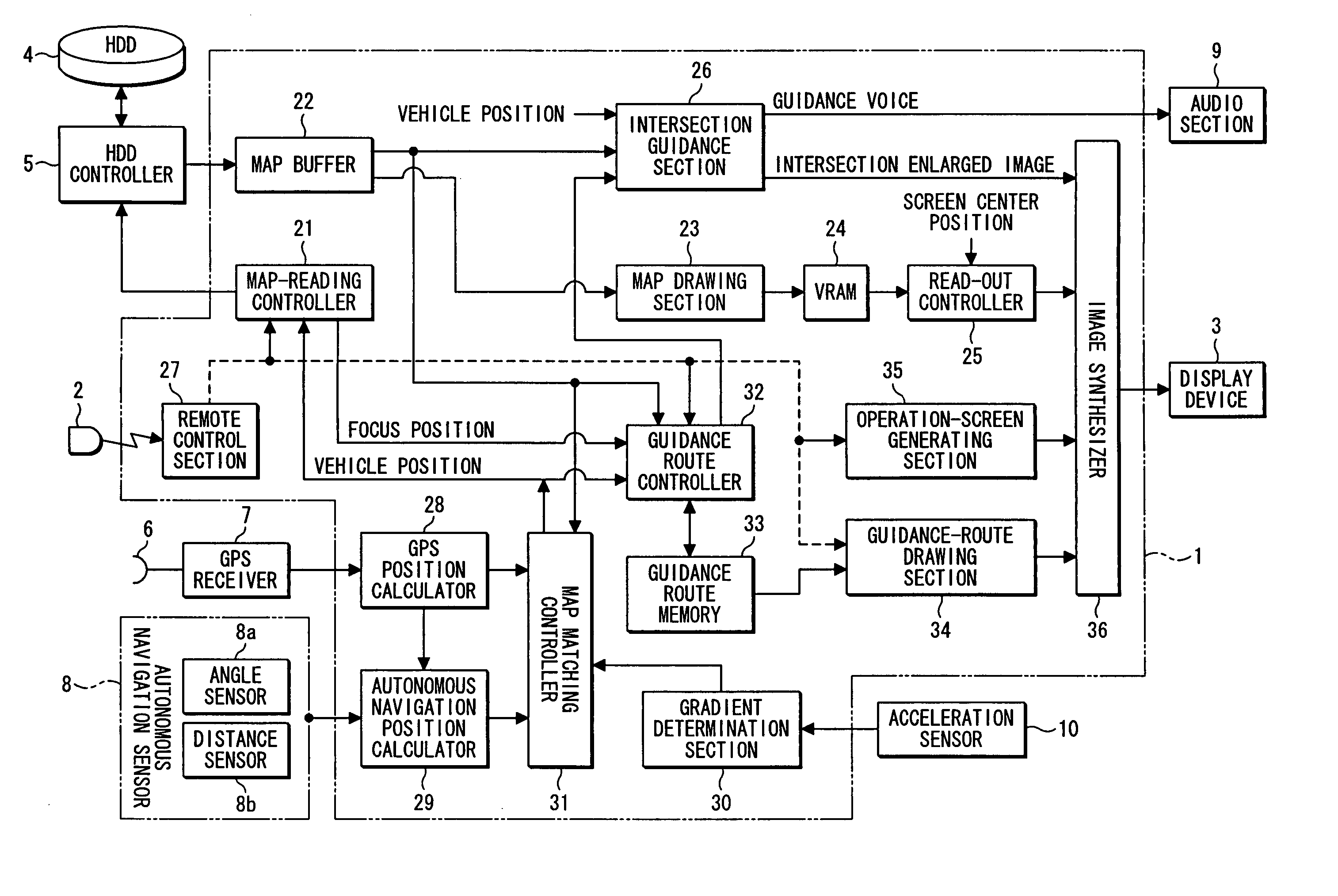
[0047]FIG. 1 is a diagram explaining one preferred embodiment of the invention.

[0048] In a navigation apparatus for displaying a map covering a position of a vehicle and its surroundings on a display device using map information, while displaying a mark indicative of the vehicle position on the map, a map database 4a stores therein map information including data for specifying a gradient of a road link. An acceleration sensor 10 detects an acceleration of the vehicle. An inclination calculator 30a of a gradient determination section 30 determines an angle of inclination θ of the road link being currently traveled, or a value (sin θ) corresponding to the angle θ, using the acceleration detected by the acceleration sensor. A vertical-deviation accumulator 30b determines a vertical distance traveled at predetermined time intervals ΔT from the inclination angle determined and from a speed of the vehicle to accumulate the distances, each serving as a vertical deviation. An upgrade / downg...


PUM


Abstract

A navigation apparatus and a map matching method are provided which enable correct determination that a vehicle is traveling a downgrade or an upgrade link. Information on gradients of road links is incorporated and stored in a map database. An acceleration sensor detects an acceleration of the vehicle. A gradient determination section determines an angle of inclination θ of the road link being currently traveled or a value corresponding to the angle θ (sin θ) using the acceleration detected by the acceleration sensor. The gradient determination section determines a vertical distance traveled from the inclination angle and from a speed of the vehicle to accumulate the distances, each serving as a vertical deviation. If the accumulated value of the vertical deviations H is larger than a set value TH, the determination section determines that the road link being traveled is the upgrade or downgrade link. A map matching processor performs map matching processing using a result of the determination and the gradient information.

Description

BACKGROUND OF THE INVENTION [0001] 1. Field of the Invention [0002] The present invention relates to a navigation apparatus and a map matching method. More particularly, the invention relates to a navigation apparatus that displays a map covering a vehicle position and its surroundings on a display device using map information, while displaying a mark indicative of the vehicle position on the map, and a map matching method. [0003] 2. Description of the Related Art [0004] A navigation apparatus is designed to read map data corresponding to a present position of a vehicle from a map data storage section, such as a DVD or a HDD, and to draw the data read on a display screen, while moving a mark indicative of the vehicle position on the map according to travel of the vehicle, or while scrolling the map with the vehicle mark fixed in a set position (for example, in a center position of the display screen) on the screen. [0005] The map data comprises (1) a road layer including node data, ...

Claims


Application Information

Patent Timeline
Patent Type & Authority Applications(United States)
IPC IPC(8): G01C21/30G01S19/48
CPCG01C21/30
Inventor KOMATSU, MICHIHISA
Owner ALPINE ELECTRONICS INC
Why Eureka
Try Eureka