GPS accumulated delta range processing for navigation applications

Active Publication Date: 2006-08-31
HARRIS CORP
View PDF20 Cites 38 Cited by
  • Summary
  • Abstract
  • Description
  • Claims
  • Application Information

AI Technical Summary

Benefits of technology

[0009] This techniques described herein combine the advantage of measuring an object's velocity over relatively long time intervals with the ability to accurately map such measurements to instantaneous velocity at the time of processing. This is accomplished by processing differenced ADR measurements and by applying a mathematical formulation that accurately maps such differences to the current state vector of the user.
[0010] The ADR measurement equations set forth herein are formulated in a

Problems solved by technology

If a short time period is used to measure the distances, the estimate of the car speed will likely not be very accurate.
While the second option is preferable, it is not always

Method used


Image

  • GPS accumulated delta range processing for navigation applications
  • GPS accumulated delta range processing for navigation applications
  • GPS accumulated delta range processing for navigation applications

Examples


Embodiment Construction

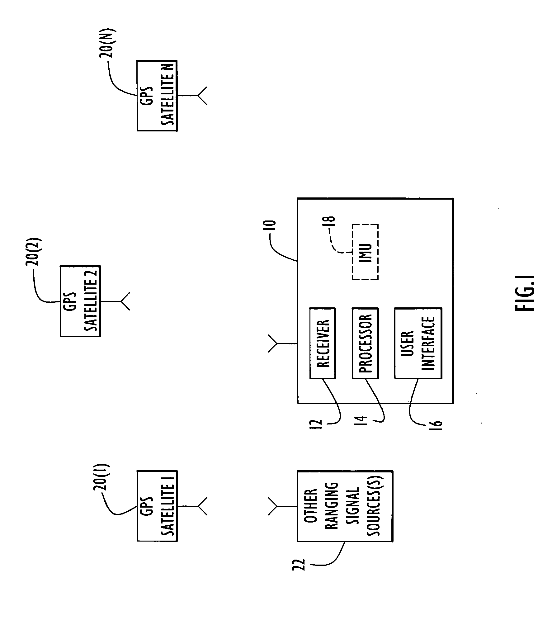
[0026]FIG. 1 illustrates an environment where the navigational techniques described herein are useful. An object 10 is shown whose position is to be computed from signals received from a plurality global positioning system (GPS) satellites 20(1) to 20(N). The object 10 may be a spacecraft such as a satellite or space vehicle, earth land or air vehicle (e.g., car, truck, tank, airplane, helicopter, ship, etc.). The object 10 has a receiver 12 that is capable of receiving signals from the GPS satellites 20(1) to 20(N), a processor 14 that makes measurements from the received signals and computes the position, velocity, direction, etc., of the object, and a object interface 16 (such as a keyboard and display) to convey navigational information to a human, if desired. In addition, the object may include an inertial measurement unit (IMU) 18 that outputs measurement data for acceleration and rotation rate of the object. The processor 14 performs computations on measurements derived from ...


PUM


Abstract

Techniques for GPS navigation used to determine the position and velocity of a moving object. Pseudorange (PR) measurements and accumulated delta range (ADR) measurements are made at the object from received GPS signals. Differences are computed between ADR measurements that are separated by a time interval that is greater than a time interval between consecutive ADR measurements. Navigational parameters (e.g., position, velocity and clock) are estimated from the PR measurements and the ADR differences. The ADR measurement equations set for herein are formulated in a much more accurate way so that the time interval between the ADR measurements used to compute an ADR difference can be much larger than that used for current ADR differencing techniques in GPS navigation applications. Consequently, the ADR differences are more accurate, which translates into a much more accurate navigation solution. In addition, the ADR differencing technique contributes to shorten convergence times of the Kalman filter processing, and thereby improve the accuracy of spacecraft navigation. Techniques are also provided to extend these highly accurate ADR processing algorithms to integrated GPS/IMU navigation applications, where IMU data is used as an accurate propagation model to propagate the state vector.

Description

RELATED APPLICATION [0001] This application claims priority to U.S. Provisional Application No. 60 / 610,609, filed Sep. 17, 2004, entitled “GPS ADR Processing for Navigation of a Spacecraft,” the entirety of which is incorporated herein by reference.FIELD OF THE INVENTION [0002] The present invention relates to global positioning system (GPS) navigation technologies, and more particularly to navigation algorithms that use accumulated delta range (ADR) measurements for more accurate navigation results. BACKGROUND OF THE INVENTION [0003] GPS is a well established means of navigation for spacecraft, aircraft as well as Earth-based vehicles or persons. Typically, a user receives signals from GPS satellites and uses pseudorange (PR) measurements from data contained in the GPS signals to determine its position, velocity and other parameters. The term “user” refers to the object whose position is computed based on GPS or other ranging signals it receives. If an application requires high acc...

Claims


Application Information

Patent Timeline
IPC IPC(8): G01C21/36G01S19/47G01S5/14G01S19/43
CPCG01S19/43G01S19/47G01S19/42G01S19/52
Inventor DRAGANOV, ALEXANDER
Owner HARRIS CORP
Why Eureka
Try Eureka