Traffic management system for a passageway environment

a traffic management system and passageway technology, applied in the field of traffic management systems, can solve the problems of large errors, inability to apply automatic systems to underground mining operations, and inability to achieve real-time global positioning technology for underground passageways, and achieve the effect of minimizing a desirable cost metri

Active Publication Date: 2007-02-01
MACDONALD DETTWILER & ASSOC INC
View PDF14 Cites 213 Cited by
  • Summary
  • Abstract
  • Description
  • Claims
  • Application Information

AI Technical Summary

Benefits of technology

[0046] In addition to merely logging data, the present invention may include a means to pre-process logged data to obtain estimates of the system's position and orientation during logging by applying dead-reckoning based on the data from one or more odometric sensors, and subsequently improving said position and orientation estimates by comparing readings from range-sensing device(s) to the readings from same range-sensing device(s) that precede them in time.
[0048] In a preferred embodiment of the invention, the generated local and global maps are metric maps (i.e., maps where the explicit notion of distance between points is defined). In this case, the invention includes a means of matching sub-regions of corresponding local metric maps and aligning said local metric maps with respect to one another in a way that minimizes a desirable cost metric. In one aspect of the invention, said odometric and range-sensing device(s) are used to create a grid-type map representation of the passageway environment, where each cell of the grid is assigned to be either occupied or not occupied.
[0050] In the preferred embodiment of the invention, the global position and orientation of the system may be represented as a sampled probability density function and a means to compute sample weights, using data acquired in real time, is used to determine the most likely global position and orientation of the system with respect to the global map. If present, the invention allows for information about RFID infrastructure and / or communication systems infrastructure to also be used for helping estimate the system's global position and orientation (e.g., for helping to estimate the initial position and orientation). The system is also capable of determining a level of confidence associated with each position and orientation estimate.

Problems solved by technology

However, for safety reasons, these automated vehicles are usually operated in underground passageways that are specified as off-limits to manually operated equipment.
However, dispatching systems (automated systems, in particular) have not been widely applied to underground mining operations.
Although there may be several reasons for this, one significant reason is the lack, at present, of real-time global positioning technology for underground passageways.
One of the drawbacks of this system is that it requires a camera and user input to help initially locate itself with respect to a previously known survey point in the walled environment, a process that must be done manually.
Moreover, the system only uses an inertial measurement unit (IMU) to determine its position after movement, which can accumulate significant errors after time.
Unfortunately, the system as claimed is not suitable for real-time positioning, and thus is unsuitable for real-time traffic management.
One reason that it is not real-time is that it requires the conversion of 3D camera data into point cloud data before a reasonably accurate position estimate can be made; this is a time consuming and unnecessary step for the current application.
One drawback of this method is that it cannot be incorporated into a self-contained system, since it requires that sensing tools be installed on a vehicle.
Thus, the system is only useful when used in conjunction with a system that utilizes said route points and is not useful as a stand-alone positioning system.
Another reason automated dispatching systems are uncommon in underground operations is the complexity of the system of passageways.
For example, unlike in most surface operations, underground passageways are often too narrow for two vehicles to pass one another, making dispatching algorithms designed for surface operations not directly applicable to underground operations.
Once production vehicles have been assigned a task by a dispatching system, one problem is the issue of ensuring that the routes taken by the vehicles are optimal with respect to the time taken by said vehicles.
Another problem is the issue of simultaneously ensuring that vehicles do not collide with each other and that their collective routes are planned as such.
However, their technique, as claimed, is dependant on the disclosed autonomous vehicle guidance system and does not explicitly function with both autonomous and manually driven vehicles, which is a significant disadvantage.

Method used


Image

  • Traffic management system for a passageway environment
  • Traffic management system for a passageway environment
  • Traffic management system for a passageway environment

Examples


Embodiment Construction

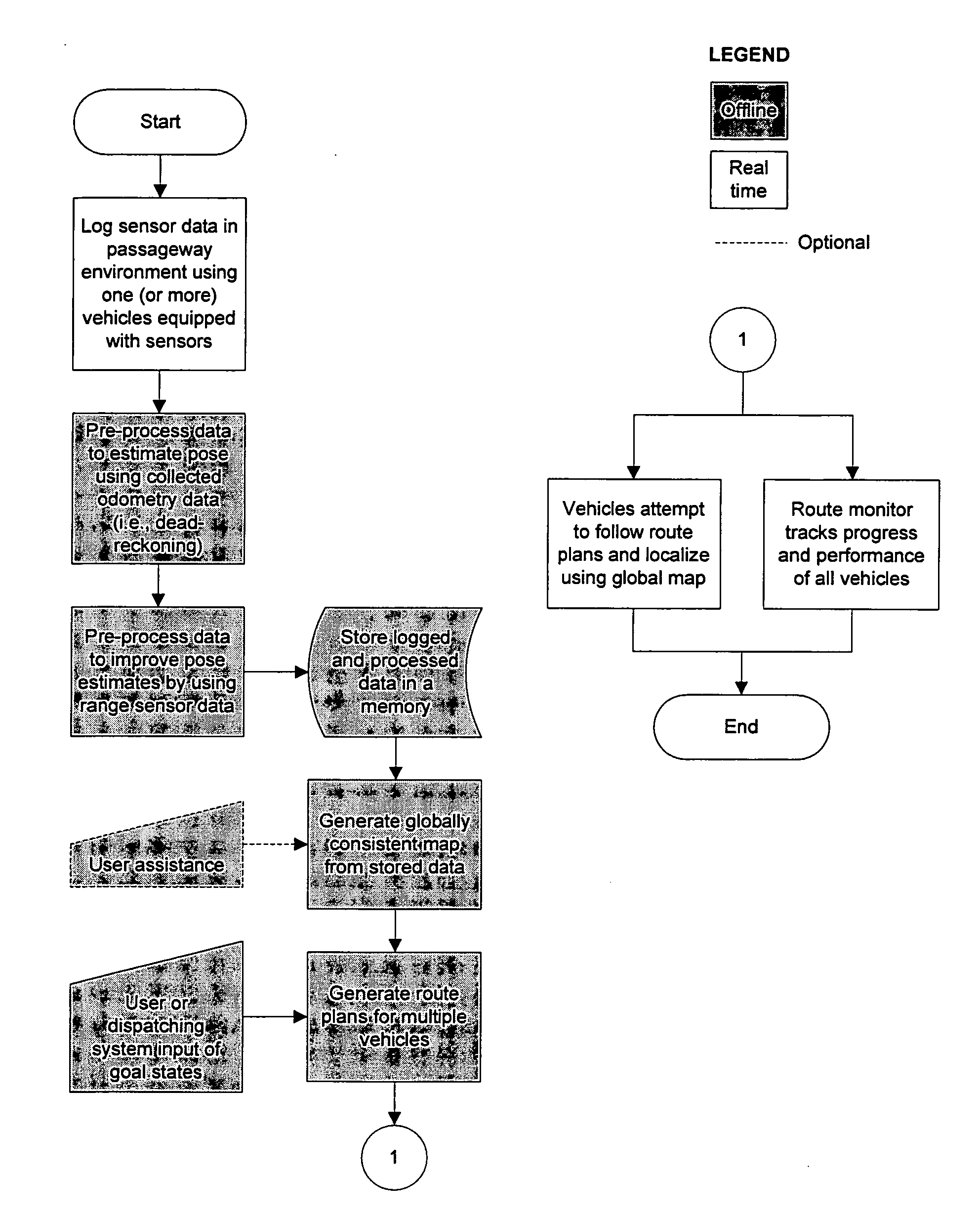
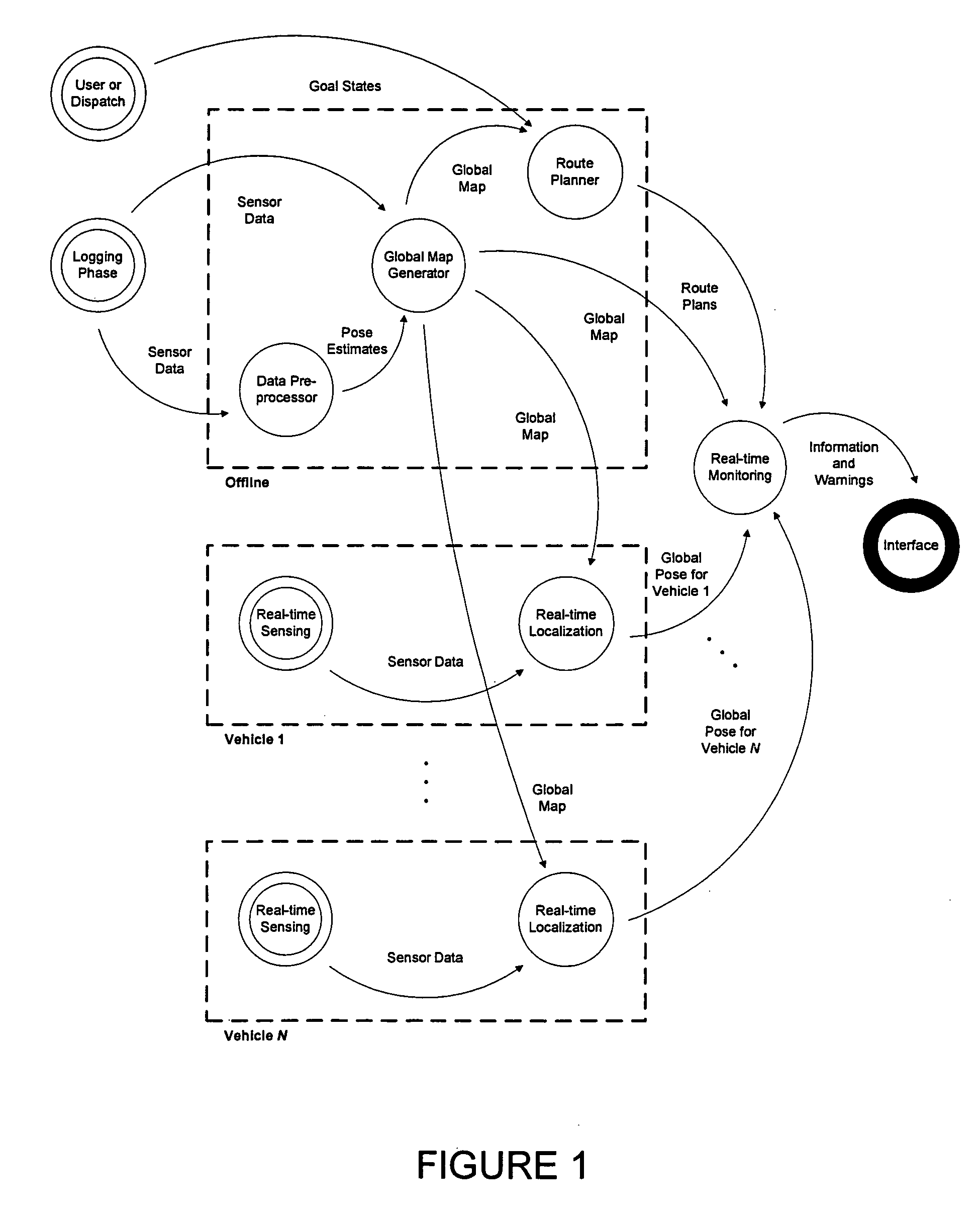
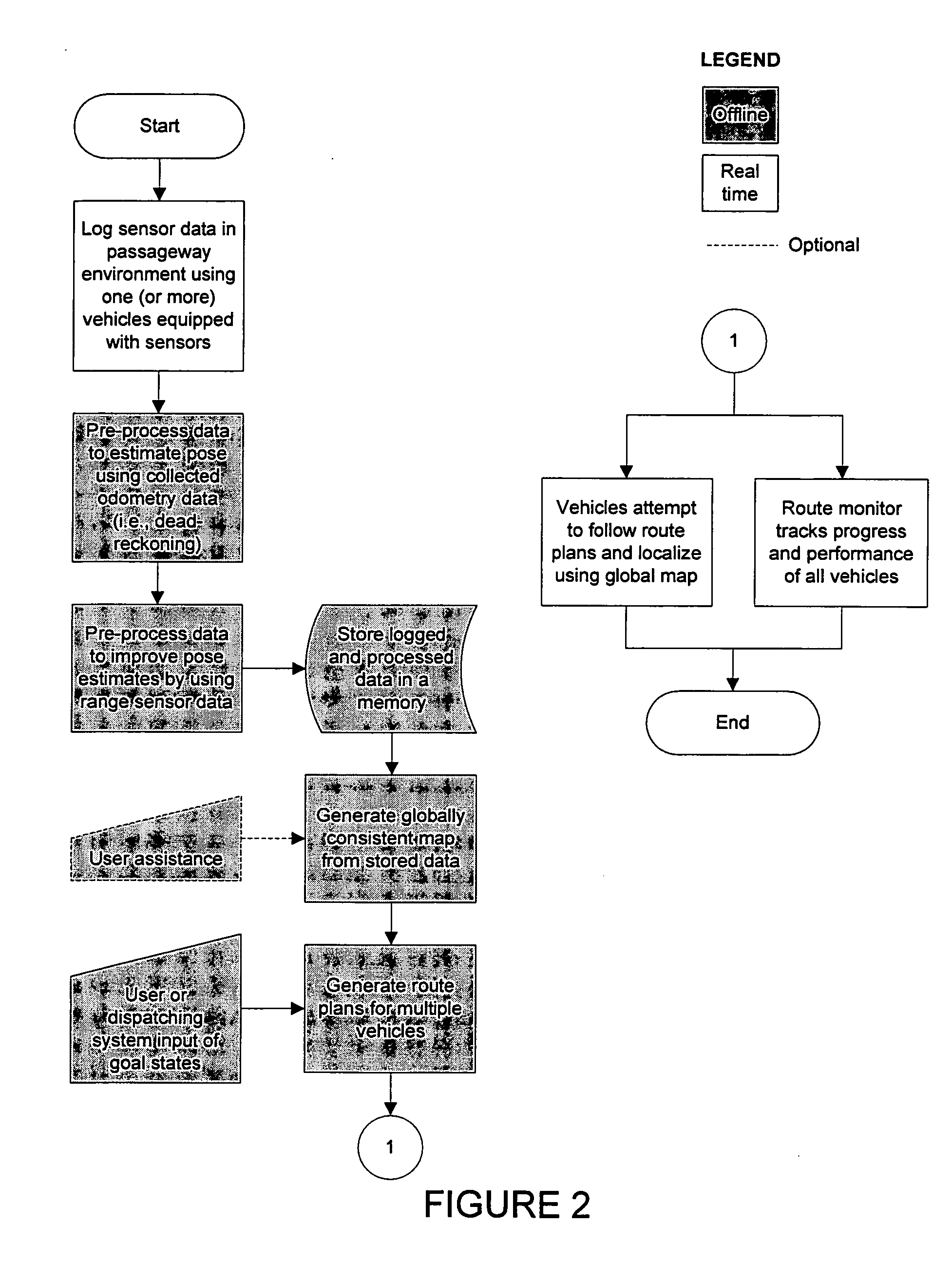
[0067] As used herein, a “map” refers to a representation of an environment and a “consistent map” refers to a map in which:

[0068] a) no two (or more) points on the map represent the same point in the physical environment;

[0069] b) no point in the map represents two (or more) points in the physical environment; and

[0070] c) if the map is a “metric map” (i.e., where the notion of distance between points is defined), then the distance between any two points in the environment is approximately correct (yet scaled) on the map.

[0071] As used herein, the phrases “local map” and “local sub-map” both mean a map of a particular region of an environment that is consistent in the region expressed by the map.

[0072] As used herein, the phrases “global map” and “globally consistent map” both mean a map of an environment that is consistent in the region expressed by the map, but which may have been created by combining one or more local maps. Thus, a local map is a global map in the region it...


PUM


Abstract

The present invention provides a system for coordinating multiple vehicles in a passageway environment (e.g., in underground mines). The system includes methods and apparatus for determining the global position and orientation of a vehicle in said passageway environment, and methods for planning routes and monitoring the travels of multiple vehicles in said passageway environment. A global position and orientation estimation system employs one or more odometric sensors and one or more range sensing devices. It works in three basic steps. In the first step, it records and processes sensor data that is descriptive of the passageway environment by moving the system through said passageway environment. In the second step, it generates a globally consistent map of said passageway environment. Finally, real-time localization is provided by employing odometric sensors and range sensing devices to determine the system's global position and orientation with respect to said globally consistent map, both initially and as it travels through the passageway environment. A route planning method accepts higher-level goals for a set of multiple vehicles in said passageway environment and generates a route plan for each vehicle that minimizes the travel time for the group of vehicles, while at the same time avoiding collisions between vehicles. Route plans are sent to the vehicles for implementation and a monitoring method tracks the global positions and orientations of the vehicles and ensures that both safety and efficiency are maintained.

Description

CROSS REFERENCE TO RELATED U.S. PATENT APPLICATION[0001] This patent application relates to U.S. utility patent application Ser. No. 60 / 702,285 filed on Jul. 26, 2005 entitled GUIDANCE, NAVIGATION, AND CONTROL SYSTEM FOR UNDERGROUND MINING VEHICLES, filed in English, which is incorporated herein in its entirety by reference. FIELD OF THE INVENTION [0002] The present invention is related to a traffic management system for coordinating multiple vehicles in a passageway environment (for example, for managing the travels of multiple mining vehicles located in an underground mine). The invention includes a system and methods for globally localizing a vehicle in a passageway environment and for planning routes and monitoring the travels of multiple vehicles. BACKGROUND OF THE INVENTION [0003] Underground mining operations typically utilize several vehicles that work together within complex arrangements of underground passageways. There may be many types of vehicles, such as load-haul-dump...

Claims


Application Information

Patent Timeline
Patent Type & Authority Applications(United States)
IPC IPC(8): G08G1/00
CPCB60W10/04B60W10/20B60W2050/0028G05B2219/40555G05B2219/45004G05D2201/021G08G1/20G08G1/202G05D1/024G05D1/0261G05D1/027G05D1/0274G05D1/0297B60W2552/00B60W2556/50
Inventor BARFOOT, TIMOTHYMARSHALL, JOSHUA
Owner MACDONALD DETTWILER & ASSOC INC
Why Eureka
Try Eureka