Portable reference station for local differential GPS corrections

Active Publication Date: 2007-04-19
HEMISPHERE GNSS
View PDF52 Cites 51 Cited by
  • Summary
  • Abstract
  • Description
  • Claims
  • Application Information

AI Technical Summary

Benefits of technology

[0013] Also disclosed herein in yet another exemplary embodiment is a storage medium encoded with a machine readable computer program code, the code including instructions for

Problems solved by technology

Depending on the separation distance between the two GPS receivers, many of the errors mentioned above will affect the satellite signals equally for the two receivers.
Subscriptions to such L1/L2 based differential services are often expensive as is the dual

Method used


Image

  • Portable reference station for local differential GPS corrections
  • Portable reference station for local differential GPS corrections
  • Portable reference station for local differential GPS corrections

Examples


Example

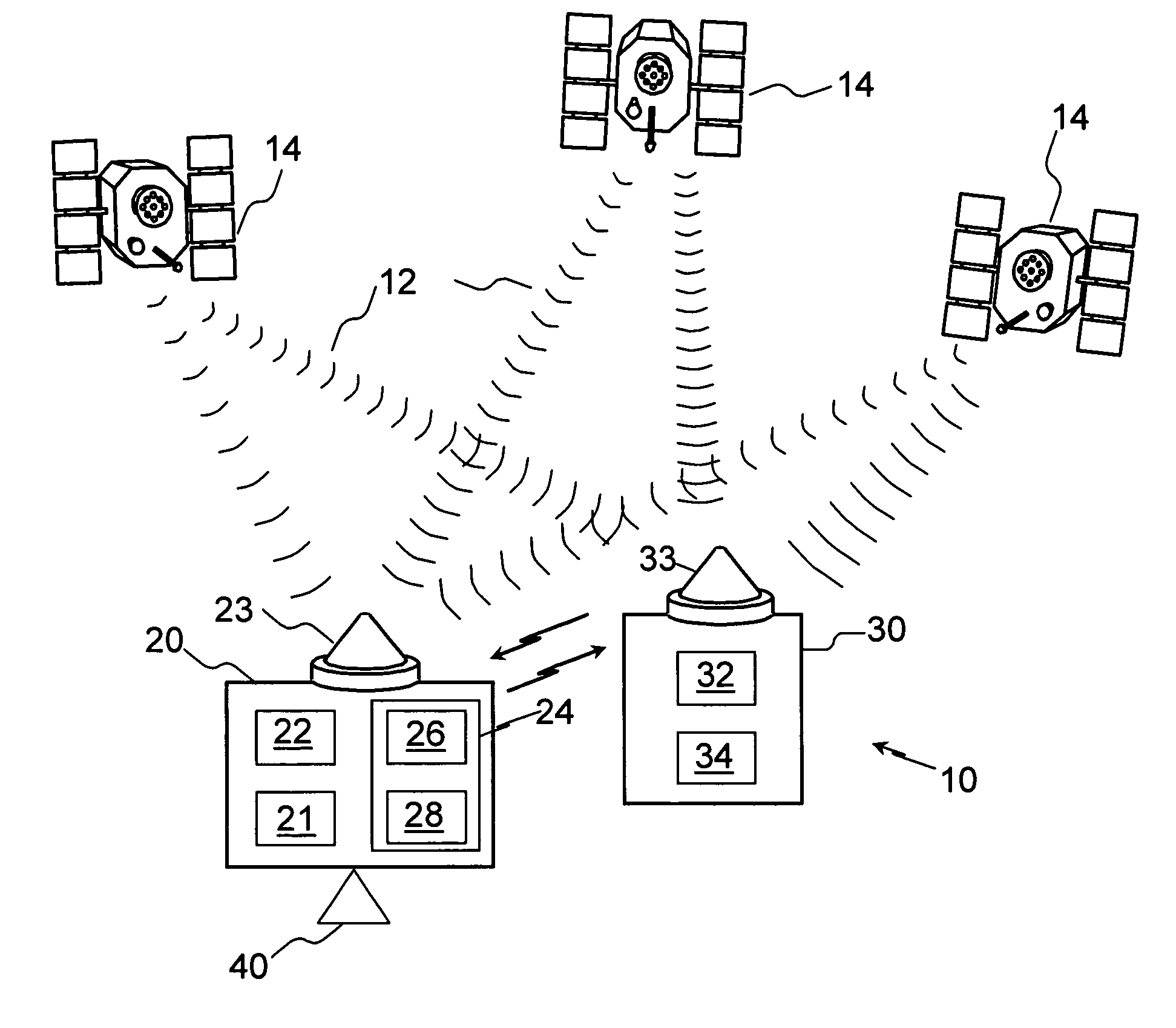
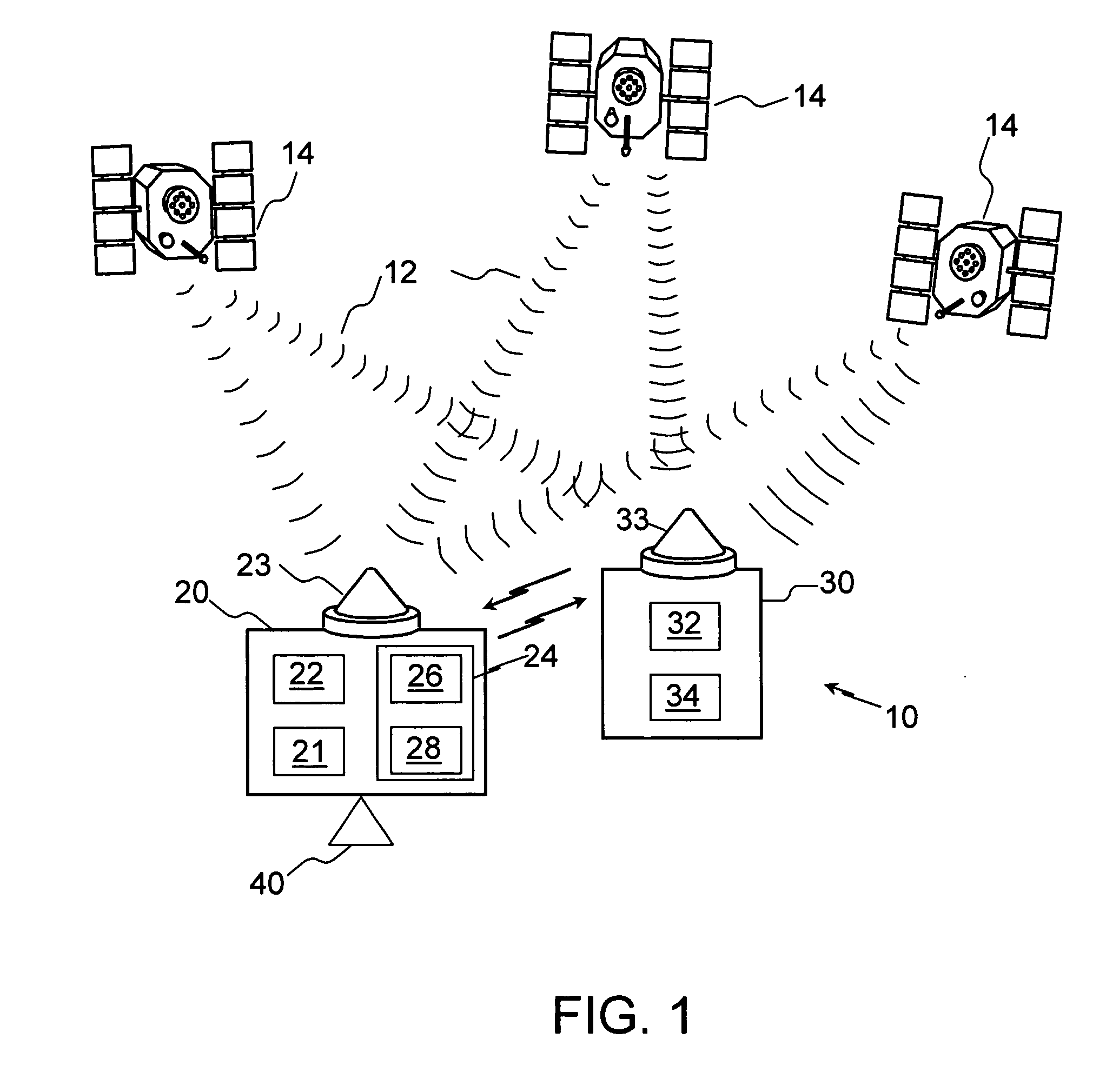
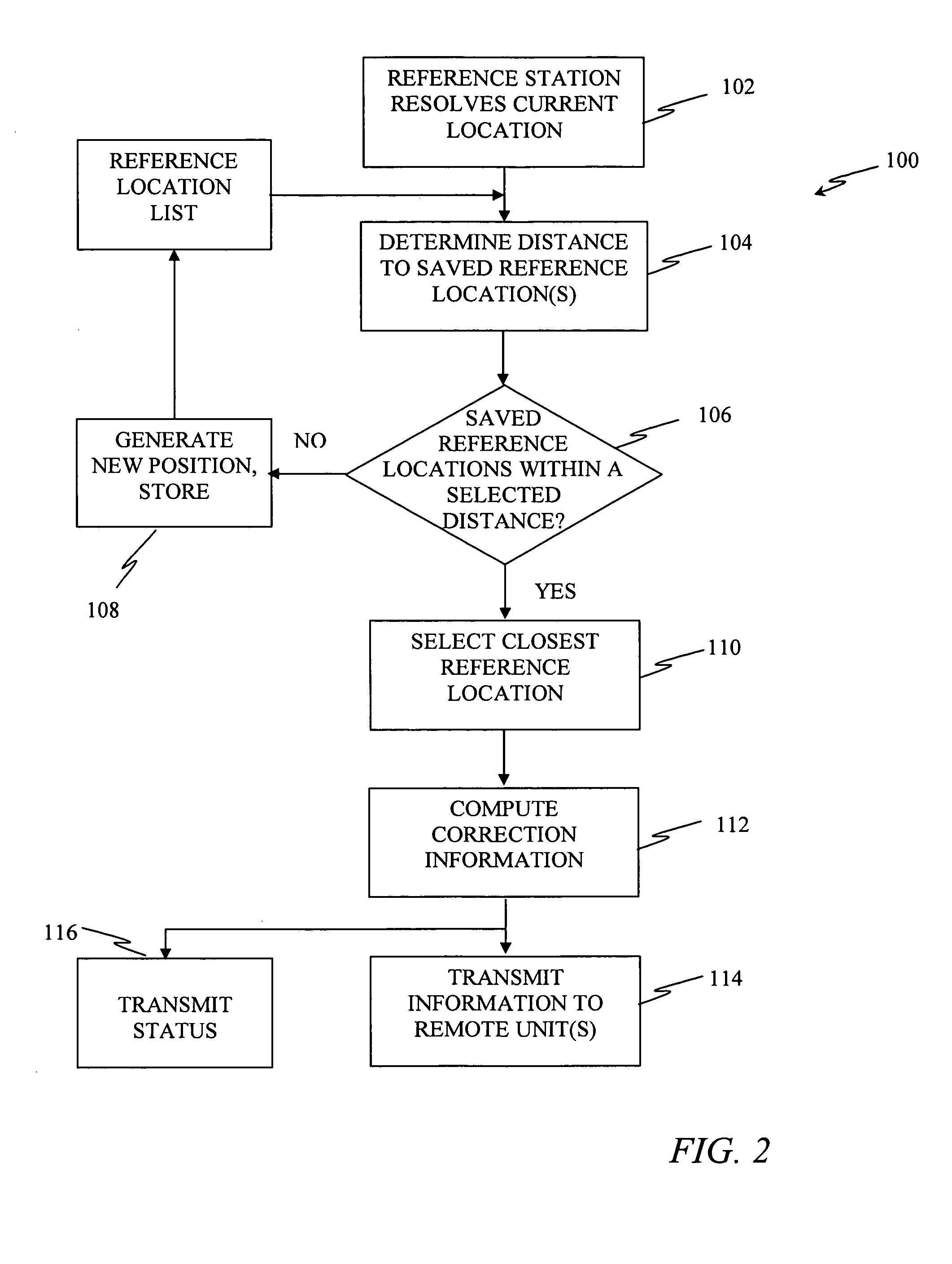
[0019] The methods and system described herein facilitate application of a differential reference station capable of being deployed with minimum user interaction. For example, in an exemplary embodiment, setup occurs automatically without the use of standard survey techniques and the setup does not require a skilled operator as in past implementations. With suitable hardware and software, the resulting DGPS positioning accuracy within a standard deviation of 0.2 m is achievable. This accuracy is repeatable, at least in a relative sense, when the reference station is returned to the same location. This is advantageous since subsequent farming operations, such as listing, planting, fertilizing, cultivating and harvesting require that the vehicle and towing implements be consistently placed in the same location. This enables such operations to produce optimum results even while using different vehicles and different farming implements that have different operational widths. The end res...


PUM


Abstract

A method and system for local computation of information to improve accuracy in a differential Global Navigation Satellite Systems (GNSS). The method comprising: determining a current location of a reference receiver; comparing the current location with at least one stored location; if a resultant of the comparing is less than a selected threshold, identifying as a reference location the at least one stored location, which is closest to the current location; otherwise establishing the current location as the reference location and storing the current location. The method also includes computing the information from signals from one or more GNSS satellites the based on the reference location; and transmitting the information for reception by one or more remote receivers.

Description

FIELD OF THE INVENTION [0001] The invention relates generally to Global Navigation Satellite System (GNSS) for example, Global Positioning System (GPS) receivers, and more particularly to a method for computing a precise relative location using a single differential GNSS / GPS receiver that acts as a reference station by generating differential correction terms. BACKGROUND [0002] One GNSS is the Global Positioning System (GPS), which was established by the United States government, and employs a constellation of 24 or more satellites in well-defined orbits at an altitude of approximately 26,500 km. These satellites continually transmit radio signals in two frequency bands, centered at 1575.42 MHz and 1227.6 MHz., denoted as L1 and L2 respectively. These signals include timing patterns relative to the satellite's onboard precision clock (which is kept synchronized by a ground station) as well as a navigation message giving the precise orbital positions of the satellites, an ionosphere ...

Claims


Application Information

Patent Timeline
IPC IPC(8): G01S5/14G01S19/14G01S19/53
CPCG01S19/07G01S19/072
Inventor WHITEHEAD, MICHAELMCCLURE, JOHN
Owner HEMISPHERE GNSS
Why Eureka
Try Eureka