
Methods, Apparatuses and Systems for the Reporting of Roadway Speed and Incident Data and the Constructing of Speed Map Database

a technology of incident data and speed map, which is applied in the field of personal real-time traffic and navigational services, can solve the problems of not producing enough benefits in the field, not addressing the problem of providing speed estimation, and not constructing a speed map for commercial use, so as to improve the quality of roadway speed information

Inactive Publication Date: 2007-07-05
AN YAFAN
View PDF6 Cites 84 Cited by
  • Summary
  • Abstract
  • Description
  • Claims
  • Application Information

AI Technical Summary

Benefits of technology

"The patent describes a method and apparatus for receiving, aggregating, and processing reported roadway location, speed, and short history of data, and constructing a roadway speed map database. The method utilizes a short speed and location history, as well as a gyro comparison algorithm as a filtering mechanism to derive accurate estimates of roadway speed for the appropriate road segments. The patent also describes mobile devices, such as mobile reporting devices, that participate in the measurement and reporting of location, speed, and road segment id to a server. The roadway speed data is then combined with map data to form a roadway speed map database, which is an representation of map and routes enriched with close-to real-time roadway speed data. The patent also describes a storage format for the extended map database, which facilitates efficient searching, estimating, retrieving, transmission, and presentation of travel time on designated routes. The patent also describes a method for qualifying, filtering, and modifying the estimated location, speed, and history data to improve the quality of roadway speed information for commercial use. Overall, the patent provides a technical solution for accurately estimating and reporting roadway speed data in a communication network."

Problems solved by technology

Due to the isolation of individual techniques, methods, and apparatuses, these fields are not producing enough benefits in deriving roadway speed map for commercial utilization.
However, location fixing does not deal with providing speed estimation, nor does it construct a speed map for commercial usage.
The current location fixing techniques, in its isolated form, do not satisfy the requirement for reliable roadway speed estimation due to the following reasons: The accuracy of certain location fixing techniques do not lead to enough accuracy for speed estimation; Spurious estimations of speed significantly degrade the accuracy of roadway speed estimates to an unusable level.
One example of this is that location fixing disregard or unable to identify whether a device is on or off a roadway, or whether it is carried by a walking person or inside a vehicle.

Method used


Image

  • Methods, Apparatuses and Systems for the Reporting of Roadway Speed and Incident Data and the Constructing of Speed Map Database
  • Methods, Apparatuses and Systems for the Reporting of Roadway Speed and Incident Data and the Constructing of Speed Map Database
  • Methods, Apparatuses and Systems for the Reporting of Roadway Speed and Incident Data and the Constructing of Speed Map Database

Examples


Embodiment Construction

[0031] In the following description, numerous details are set forth. It will be apparent, however, to one skilled in the art, that the present invention may be practiced without these specific details. In other instances, well-known structures, procedures, and devices are shown in block diagrams, brief introductions, or pictures, rather than in detail, in order to avoid obscuring the present invention.

[0032] Some portions of the detailed descriptions below are presented in terms of algorithms and symbolic representations of operations on data bits within a computer memory. These algorithmic descriptions and representations are the means used by those skilled in the data processing arts to most effectively convey the substance of their work to others skilled in the art. An algorithm is here, and generally, conceived to be a self-consistent sequence of steps leading to a desired result. The steps are those requiring physical manipulations of physical quantities. Usually, though not n...


PUM


Abstract

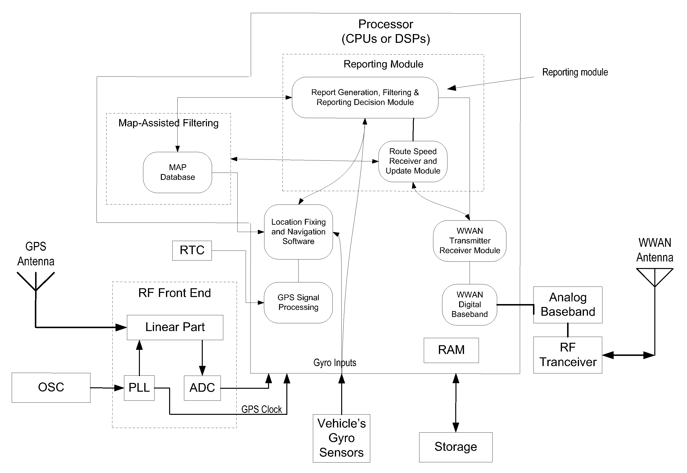
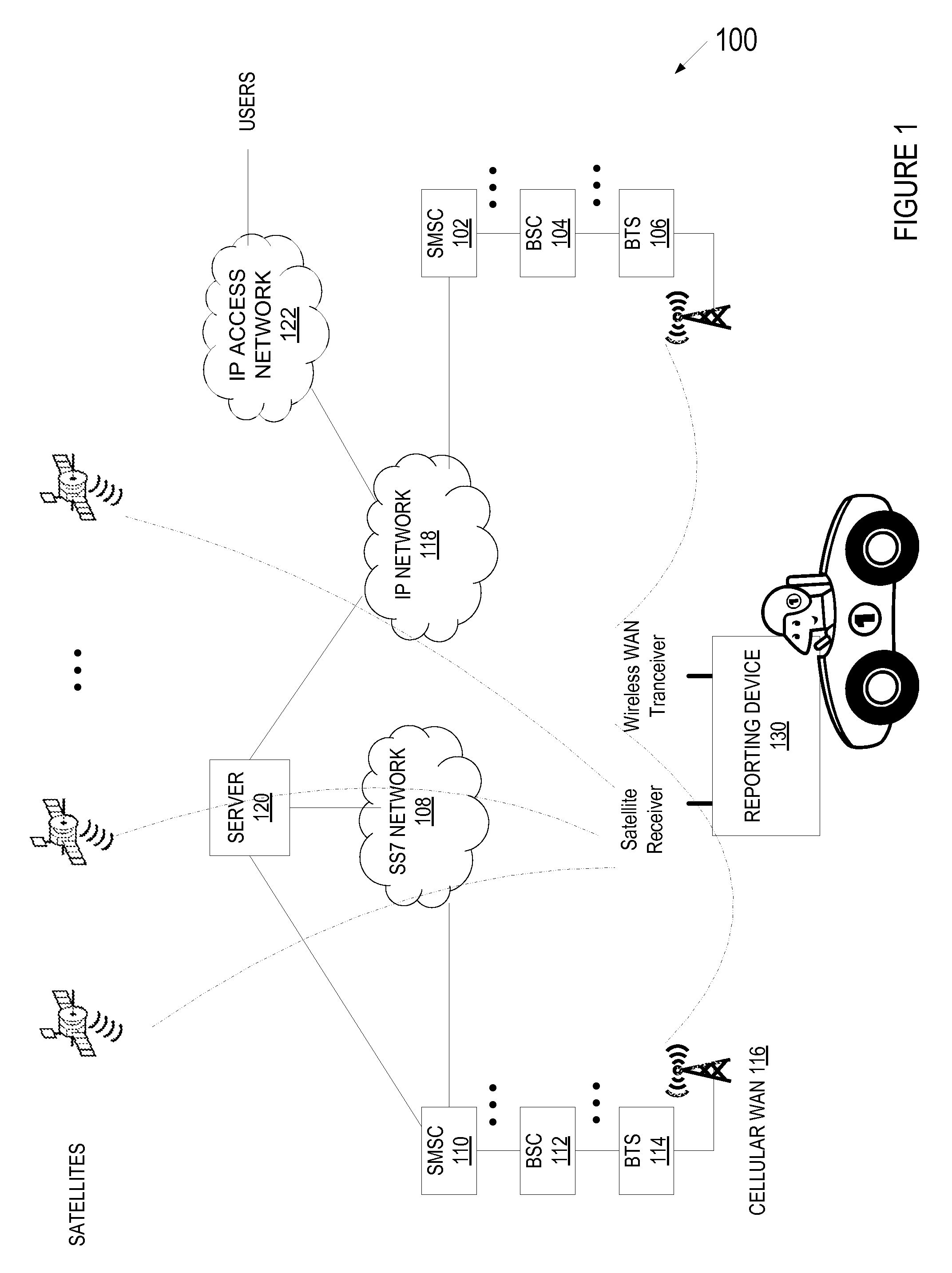
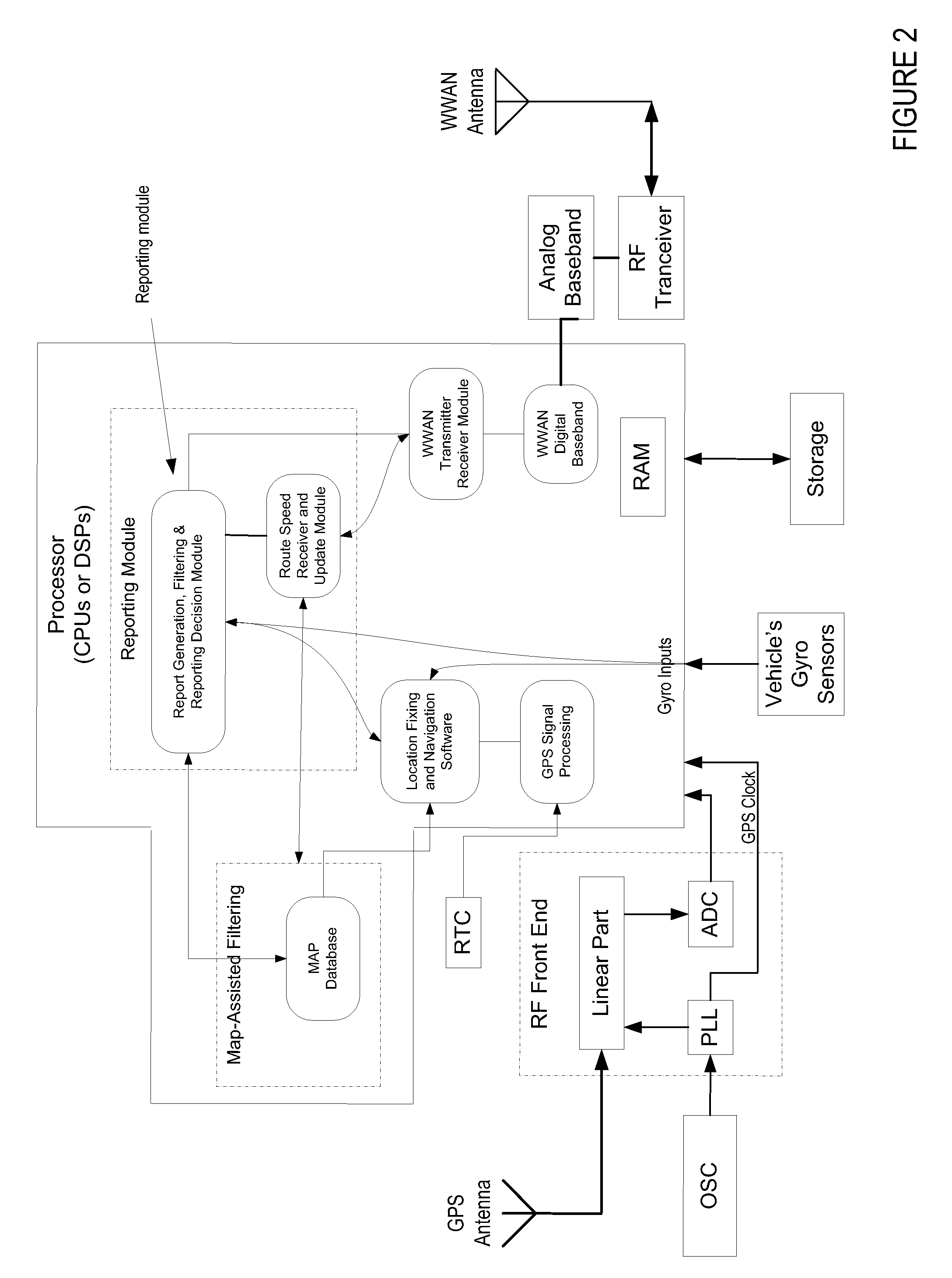
A method and architecture for constructing, updating, and maintaining a map database extended with real-time roadway speed data is described. The method and system include a plurality of mobile reporting devices, communication channels, and servers that receive the speed and incident reports and maintain an extended map database. The extended map database is a spatial database with extended speed attributes. The reporting devices or the server use map-assisted filtering and gyro history comparison to ensure a reported speed is snapped to a valid road segment and with sufficient accuracy.

Description

[0001] This application claims benefit of provisional application 66 / 766043 filed on Dec. 30, 2005.FIELD OF INVENTION [0002] The present invention relates to personal real-time traffic and navigational services. More specifically, the current invention relates to the methods, apparatuses, and systems for gathering, reporting, processing, and utilizing of roadway speed, travel time, and roadway incident data for informational, navigational and other services. Even more specifically, this invention relates to the use of communication systems for gathering, filtering, reporting, and processing these data into a usable form. BACKGROUND OF INVENTION [0003] Telematics refers to the integrated use of telecommunications and informatics, also known as ICT (Information and Communications Technology). It is the science, technology, systems, and services of sending, receiving and storing of information via telecommunication devices. It generally involves a wireless communications system for the...

Claims


Application Information

Patent Timeline
Patent Type & Authority Applications(United States)
IPC IPC(8): H04Q7/20
CPCG08G1/20G08G1/01
Inventor AN, YAFAN
Owner AN YAFAN
Learn More