Systems, methods and apparatuses for continuous in-vehicle and pedestrian navigation

a technology of continuous in-vehicle and pedestrian navigation, applied in the direction of distance measurement, navigation instruments, instruments, etc., can solve the problems of inability to optimize the positioning of the antenna, inability to utilize the single system for both vehicles and pedestrians, inaccurate drs and ins, etc., to simplify the use of the device by consumers, the effect of minimizing processing

Inactive Publication Date: 2007-07-05
INTRINSYC SOFTWARE INT
View PDF28 Cites 90 Cited by
  • Summary
  • Abstract
  • Description
  • Claims
  • Application Information

AI Technical Summary

Benefits of technology

[0006] According to an embodiment of the invention, there is disclosed a Destinator Continuous Navigation (DCN) module that includes an accelerometer, such as a 3-D MEM (Micro-Electro-Mechanical) accelerometer, to calculate vehicle and pedestrian distance traveled during GPS signal outages. A 3-D magnetometer may also be incorporated into the DCN module, as well as an altimeter and / or temperature sensor. The DCN module does not interface to the vehicle or a pedestrian in any way other than mechanically (e.g., being mounted in a vehicle, placed on the dash board of the vehicle, or carried by a pedestrian or placed on the pedestrian's back). The utilization of GPS together with these inertial navigation sensors will allow seamless, continuous navigation regardless of the GPS status.
[0007] According to another aspect of the invention, the DCN module may be used for both in-vehicle and pedestrian navigation. Therefore, different portable hardware and / or digital signal processing software is not required to effect different navigation uses (i.e., in-vehicle or pedestrian navigation). According to yet another aspect of the invention, MEMs accelerometers employed are effectively utilized as a microphone to extract the vehicle (or pedestrian) velocity noise vector, termed in this document as the 3-D acceleration vector or 3-D pseudo-acceleration vector. The present invention includes a 1-step integration method to extract vehicle (or pedestrian) distance from MEMs accelerometer sensor readings, which simplifies and minimizes the processing required to determine distance traveled without a GPS signal. According to another aspect of the invention, no step calculations are required to permit pedestrian navigation, thereby simplifying use of the device by a consumer.

Problems solved by technology

They may also be unavailable due to external forces such as bad weather conditions or signal interference.
Furthermore, optimal antenna positioning is not always possible in enabling a good reception of signals from such systems.
However, conventional DRS and INS are inaccurate and a single system may not be utilized by both vehicles and pedestrians for navigation.

Method used


Image

  • Systems, methods and apparatuses for continuous in-vehicle and pedestrian navigation
  • Systems, methods and apparatuses for continuous in-vehicle and pedestrian navigation
  • Systems, methods and apparatuses for continuous in-vehicle and pedestrian navigation

Examples


Embodiment Construction

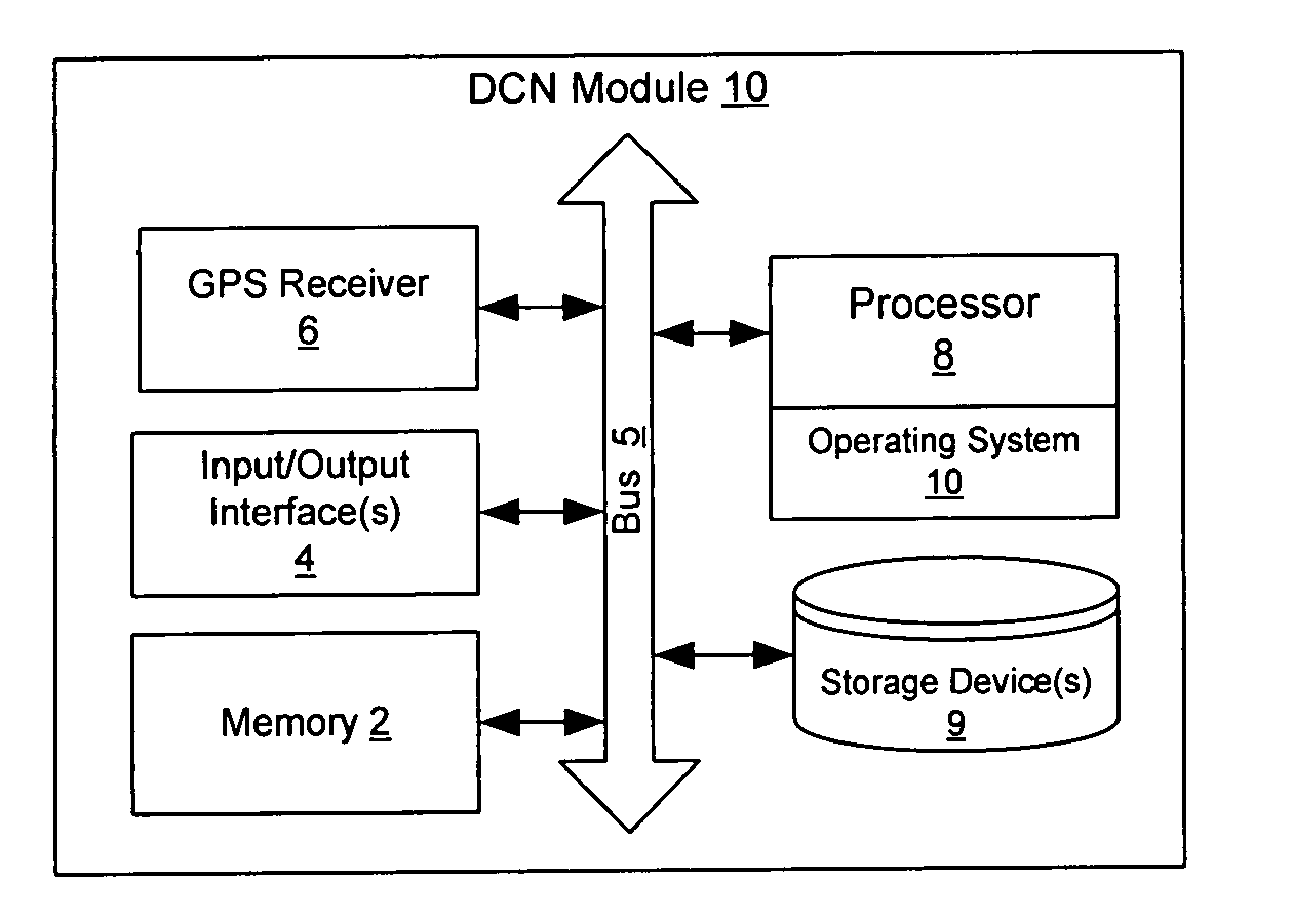
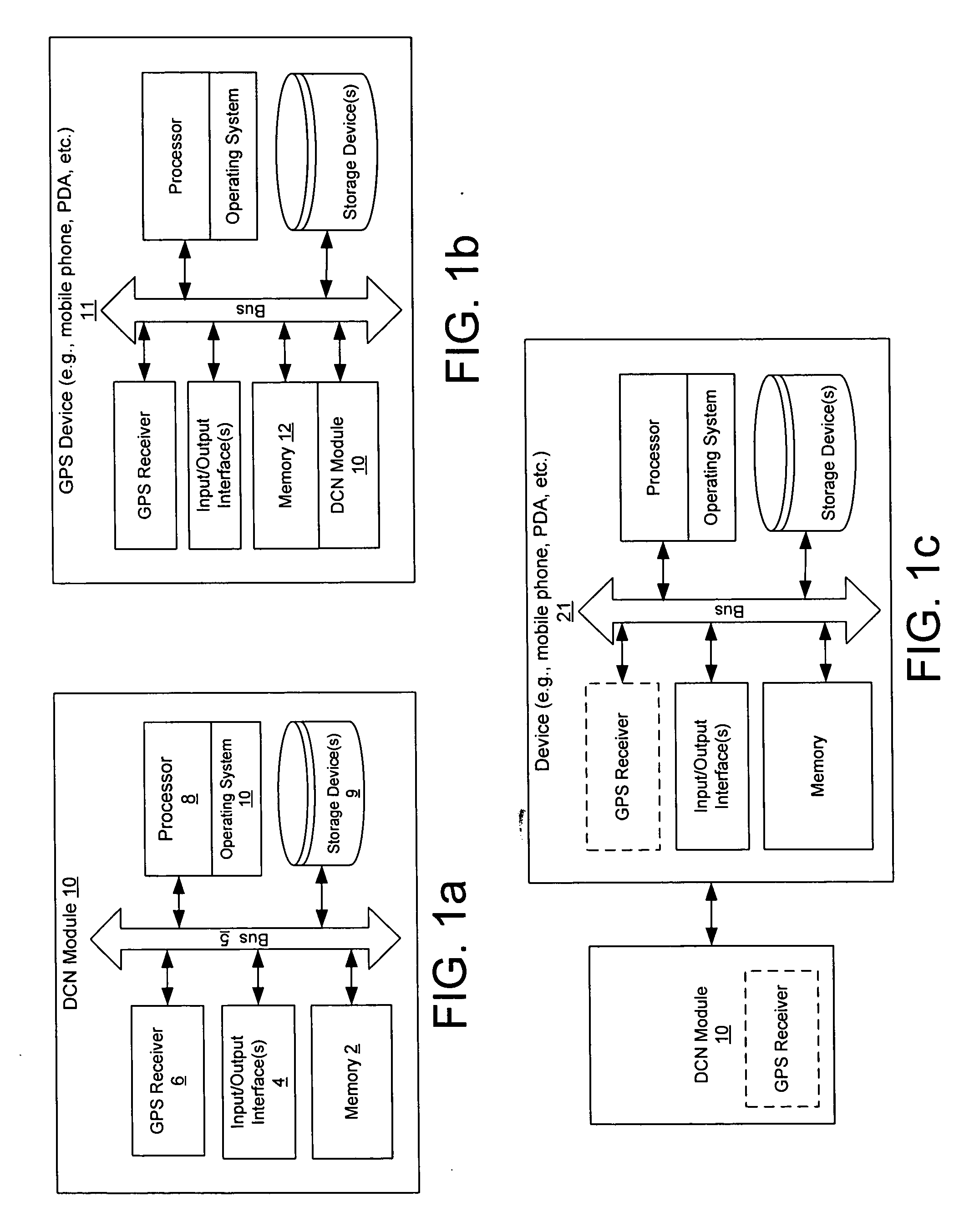
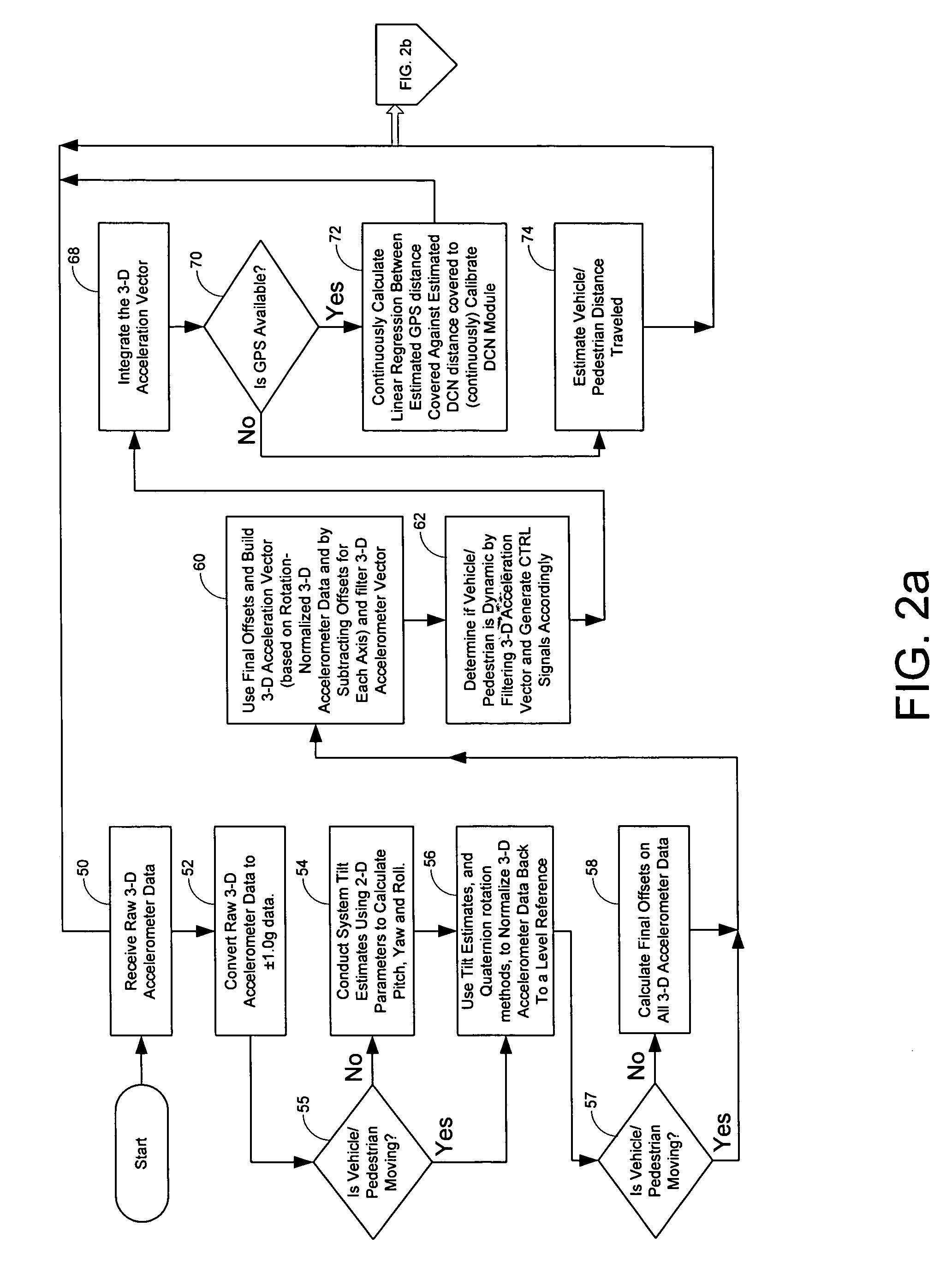
[0069] The present inventions now will be described more fully hereinafter with reference to the accompanying drawings, in which some, but not all embodiments of the invention are shown. Indeed, these inventions may be embodied in many different forms and should not be construed as limited to the embodiments set forth herein; rather, these embodiments are provided so that this disclosure will satisfy applicable legal requirements. Like numbers refer to like elements throughout.

[0070] It will be appreciated that the present invention is described below with reference to block diagrams illustrations of methods, apparatuses, systems and computer program products according to an embodiment of the invention. It will be understood that each block of the block diagrams and combinations of blocks in the block diagrams, respectively, can be implemented by computer program instructions. These computer program instructions may be loaded onto a general purpose computer, special purpose compute...


PUM


Abstract

Accelerometers are used to provide acceleration data in 3 dimensions, from which vehicle distance traveled may be calculated during GPS outage using a one step integration of a 3-D pseudo acceleration vector. Magnetometers may also be used in combination with the accelerometers to calculate direction of travel. The system may be utilized for combined in-vehicle navigation and pedestrian navigation applications, and the same hardware is utilized for both system applications.

Description

RELATED APPLICATION DATA [0001] The present application claims priority to U.S. Provisional Patent Application Ser. No. 60 / 755,133, filed Dec. 30, 2005, titled “Systems, Methods and Apparatuses for Continuous In-Vehicle and Pedestrian Navigation”, the entire contents of which are incorporated herein by reference as if set forth fully herein.FIELD OF THE INVENTION [0002] The present invention relates generally to dead-reckoning systems, and more particularly, to systems, apparatuses, methods, and computer program products that enable continuous navigation of a person or vehicle without requiring GPS signals. BACKGROUND OF THE INVENTION [0003] Navigation electromagnetic waves such as those transmitted by GPS and GLONASS satellites may be interrupted or affected by multi-path in urban canyons, suburban or wooded environments, and the like. They may also be unavailable due to external forces such as bad weather conditions or signal interference. Furthermore, optimal antenna positioning ...

Claims


Application Information

Patent Timeline
Patent Type & Authority Applications(United States)
IPC IPC(8): G01C21/00G01S5/14G01S19/49
CPCG01C21/165G01S19/49G01C22/006G01C21/28G01C21/1654
Inventor YANNI, MAMDOUH
Owner INTRINSYC SOFTWARE INT
Why Eureka
Try Eureka