Navigation apparatus

a navigation system and a technology for identifying devices, applied in the direction of navigation instruments, instruments, knowledge representation, etc., can solve the problems of large detection errors, incorrect mapping of navigation systems, and inaccurate mapping of roads connected to unregistered roads, etc., and achieve the effect of higher degree of accuracy

Inactive Publication Date: 2007-09-13
AUTO TECH GRP LLC
View PDF15 Cites 38 Cited by
  • Summary
  • Abstract
  • Description
  • Claims
  • Application Information

AI Technical Summary

Benefits of technology

[0010]The navigation apparatus according to the present invention defines, as a detection section for an unregistered road, a section between two points respectively on registered roads in which the state of the identification of the current position of the vehicle is the matching state, the two points being respectively located before and behind sections in which the state of the identification is the free state, performs a coordinate transformation on a traveling path between the two points which is estimated regardless of processing carried out by the road matching means so that the start point and end point of the traveling path have coordinates which match with the coordinates of the two points, respectively, determines that sections of the traveling path which are similar to parts of the registered roads, respectively, and which are running in parallel with the parts of the registered roads overlap the registered roads, respectively, if each of the amount of movement in the coordinate system, expansion and contraction coefficient, and rotation angle of the traveling path, which are caused by the coordinate transformation, falls within a predetermined range which is estimated from the accuracy of the current position of the vehicle and the accuracy of correction of the sensor, and removes the sections of the traveling path from the traveling path, and then detects the coordinates of the unregistered road from the remaining traveling path. Therefore, the navigation apparatus in accordance with the present invention can prevent detection of an unregistered road with a low degree of reliability, and can detect the coordinates of an unregistered road with a higher degree of accuracy. As a result, the navigation apparatus in accordance with the present invention can carry out route searching and route guidance on the basis of the road data including data about unregistered roads.

Problems solved by technology

However, the prior art navigation apparatus disclosed by patent reference 1 has the following problems.
That is, because the prior art navigation apparatus is so designed as to carry out a map matching process of comparing road data with the current position of the vehicle on the assumption that the vehicle travels a road, it is difficult for the prior art navigation apparatus to determine that the current position of the vehicle is out of any registered road indicated by the road data when it is placed in a matching state in which the current position of the vehicle is map-matched onto a registered road, and, when the vehicle travels an unregistered road while the prior art navigation apparatus is placed in a free state (i.e., a state which is not the matching state), the prior art navigation apparatus may determine that the current position of the vehicle is on a registered road incorrectly if the registered road runs in parallel with and in the vicinity of the traveling path of the vehicle.
On the other hand, when there are two or more roads near the current position of the vehicle, the prior art navigation apparatus does not determine that the current position of the vehicle is on a registered road until it will have continued to recognize a similarity in the shape of the traveling path of the vehicle and consistency of the current position of the vehicle with the registered road while the vehicle has been traveling a predetermined distance or longer.
A problem with the prior art navigation apparatus is therefore that when it detects the coordinates of an unregistered road and registered roads to which the unregistered road is connected from the traveling path of the vehicle in a section where the prior art navigation apparatus is placed in the free state in which the current position of the vehicle is out of any registered road, large errors occurs in the detection results.
A problem with the prior art creation method of creating road map data disclosed by patent reference 2 is that a navigation system using the creation method cannot detect any unregistered road when the user cannot operate the navigation system even if the user wants to operate it (e.g., when the user is driving a well-trafficked road) or when the user has forgotten to operate the navigation system, the navigation system cannot detect any unregistered road, and, when the user has failed to operate it (when the user is driving an unfamiliar area, the user may not perform operations correctly to set up the first and second points), the navigation system specifies roads connected to an unregistered road incorrectly.

Method used


Image

  • Navigation apparatus
  • Navigation apparatus
  • Navigation apparatus

Examples


embodiment 1

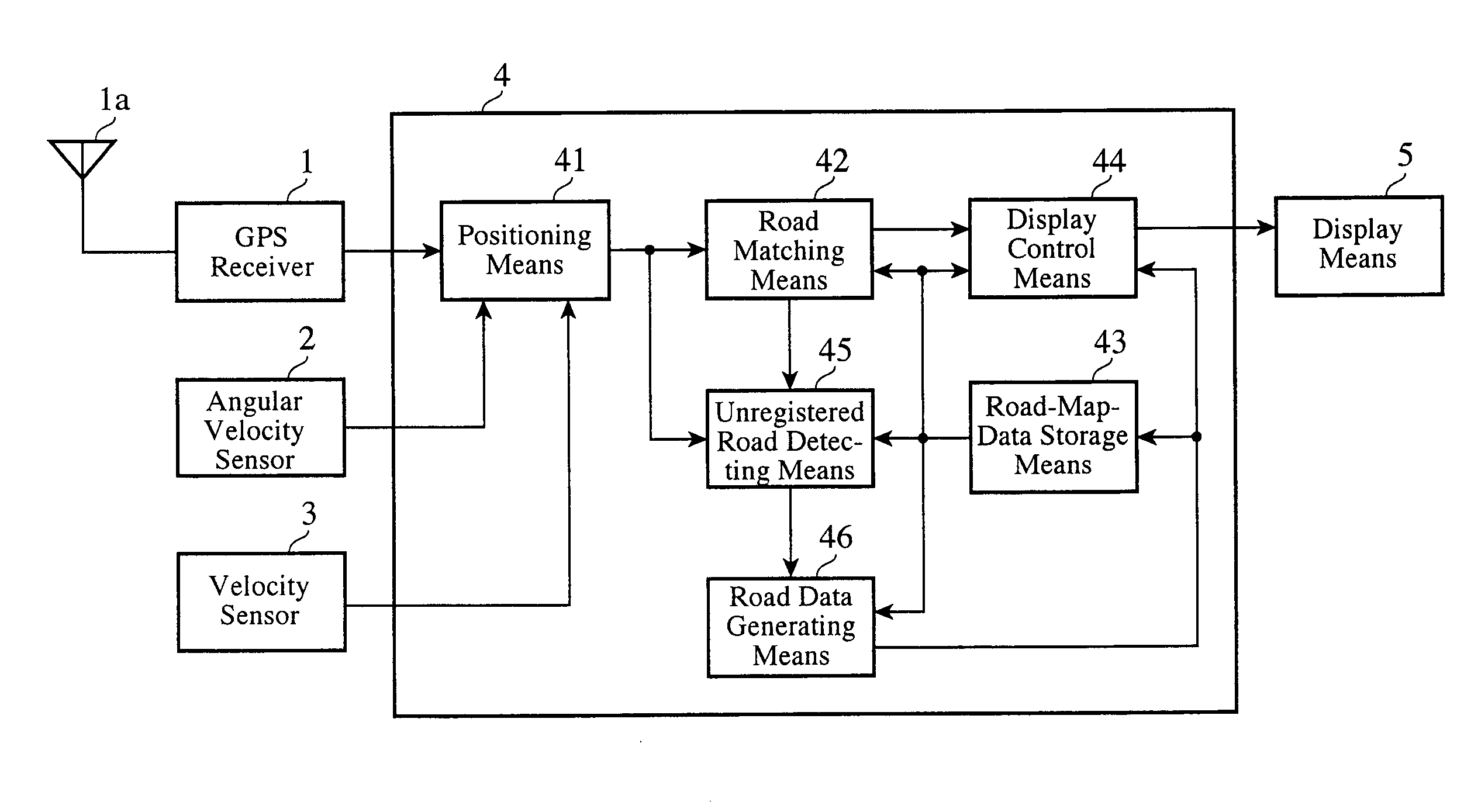
[0036]FIG. 1 is a block diagram showing the structure of a navigation apparatus according to embodiment 1 of the present invention. This navigation apparatus is provided with a GPS (Global Positioning System) receiver 1, an angular velocity sensor 2, a velocity sensor 3, a signal processing unit 4, and a display unit 5. The sensors of this navigation apparatus according to the present invention thus include the GPS receiver 1, angular velocity sensor 2, and velocity sensor 3.

[0037]The GPS receiver 1 receives GPS electric waves transmitted thereto from GPS satellites by way of a GPS antenna 1a, and generates a GPS signal. The angular velocity sensor 2 detects the angle of turning of a vehicle equipped with the navigation apparatus, and generates an angular velocity signal.

[0038]The velocity sensor 3 detects the velocity of the vehicle and generates a velocity signal. The GPS signal generated by the GPS receiver 1, the angular velocity signal generated by the angular velocity sensor 2...

embodiment 2

[0069]In the navigation apparatus according to above-mentioned embodiment 1, when the vehicle passes through an unregistered tunnel while an error occurs in the bias of the angular velocity sensor 2, any bias drift cannot be corrected for on the basis of the GPS signal from the GPS receiver 1 and the road data read from the road-map-data storage means 43. Therefore, in such a case, an error of the traveling direction of the vehicle and an error of the position of the vehicle increase gradually, and, when the GPS signal is acquired from the GPS receiver 1 immediately after the vehicle has passed through an unregistered tunnel, the current position of the vehicle is amended on the basis of this GPS signal. In this case, because a “position jump” occurs and the traveling path is then separated into portions immediately after the vehicle has passed through the tunnel, as shown in FIG. 10a, the generation of road data using the coordinates of the traveling path in the state where the tra...

embodiment 3

[0073]As shown in FIG. 11, even if the vehicle travels an identical road several times, there is a possibility that the coordinates of the traveling path of the vehicle have variations resulting from errors in the velocity sensor 3, the angular velocity sensor 2, and the GPS receiver 1, and the coordinates of a vehicle return point (or a point B′) where an unregistered road is connected to a registered road have an error range extending in the direction of the registered road, as shown in FIG. 12. To solve this problem, in the navigation apparatus according to embodiment 1, the unregistered road detecting means 45 defines, as the point B, the coordinates of the current position of the vehicle which the road matching means 42 has identified as being on a registered road in step ST410 of FIG. 4, as to a timing of setting up the detection end point (or the point B) by means of the unregistered road detecting means 45.

[0074]In contrast, in a navigation apparatus according to this embodi...


PUM


Abstract

A navigation apparatus includes an unregistered road detecting means for setting up a detection start point and a detection end point for an unregistered road on registered roads which are respectively located before and behind sections in which matching result data indicates a free state, respectively, the matching result data indicating a matching state when the vehicle is traveling each of the registered roads, for performing a coordinate transformation on a traveling path which is created from positioning data and which is extending between the two points so that the traveling path has coordinates which match with the coordinates of a registered road between them, and for detecting the coordinates of the unregistered road from a portion of the coordinate-transformed traveling path which does not overlap any registered road, and a road data generating means for creating road data about the unregistered road from the coordinates of the unregistered road.

Description

BACKGROUND OF THE INVENTION[0001]1. Field of the Invention[0002]The present invention relates to a navigation apparatus. More particularly, it relates to a technology for, when a vehicle equipped with the navigation apparatus has traveled an unregistered road about which road data is not registered in the navigation apparatus, creating road data about the unregistered road from the traveling path of the vehicle.[0003]2. Description of Related Art[0004]Conventionally, a navigation apparatus which creates road data about an unregistered road and registers the road data in road map data when a vehicle equipped with the navigation apparatus has traveled the unregistered road about which road data is not registered in the road map data is known. For example, patent reference 1 discloses a navigation apparatus which stores the traveling path of a vehicle when the vehicle has traveled an off-road, and, after that, reads the traveling path so as to display it, and a navigation method at a t...

Claims


Application Information

Patent Timeline
Patent Type & Authority Applications(United States)
IPC IPC(8): G01C21/00
CPCG01C21/26G09B29/102G01C21/30
Inventor ISHIGAMI, TADATOMINISHIUMA, NORIHIROSAWA, YOSHITSUGUGOTO, YUKIOKUMAZAWA, HIROYUKIUMEZU, MASAHARUIKEUCHI, TOMOYAKOHNO, ATSUSHIISHIDA, MASAYUKISHIMOTANI, MITSUO
Owner AUTO TECH GRP LLC
Why Eureka
Try Eureka