Method and apparatus for remote characterization of faults in the vicinity of boreholes

a technology for faults and remote sensing, applied in seismology for waterlogging, borehole/well accessories, instruments, etc., can solve the problems of ineffective and costly drilling of boreholes, and inability to accurately characterize faults in the vicinity of boreholes

Active Publication Date: 2008-08-21
GEOMECHANICS INT
View PDF10 Cites 24 Cited by
  • Summary
  • Abstract
  • Description
  • Claims
  • Application Information

AI Technical Summary

Benefits of technology

[0006]In one embodiment of the invention, wireline and / or real-time imaging or other data from which the characteristics of breakouts along the wellbore can be determined as a function of positional along a well bore are used to constrain fault location(s) away from the borehole by modeling the effects of fault-induced stress changes on the characteristics of such breakouts.

Problems solved by technology

In general, direct sampling techniques such as the drilling of boreholes are undesirably inefficient and costly.
On the other hand, remote sensing technologies and modeling techniques have been employed in the prior art with limited success, and there thus remains an ongoing need for improved techniques for remote characterization of tectonic features or conditions, such as active faults in the proximity of but not necessarily penetrated by a borehole.

Method used


Image

  • Method and apparatus for remote characterization of faults in the vicinity of boreholes
  • Method and apparatus for remote characterization of faults in the vicinity of boreholes
  • Method and apparatus for remote characterization of faults in the vicinity of boreholes

Examples


Embodiment Construction

[0016]In the disclosure that follows, in the interest of clarity, not all features of actual implementations are described. It will of course be appreciated that in the development of any such actual implementation, as in any such project, numerous engineering and technical decisions must be made to achieve the developers' specific goals and subgoals (e.g., compliance with system and technical constraints), which will vary from one implementation to another. Moreover, attention will necessarily be paid to proper engineering practices for the environment in question. It will be appreciated that such a development effort might be complex and time-consuming, but would nevertheless be a routine undertaking for those of ordinary skill in the relevant fields.

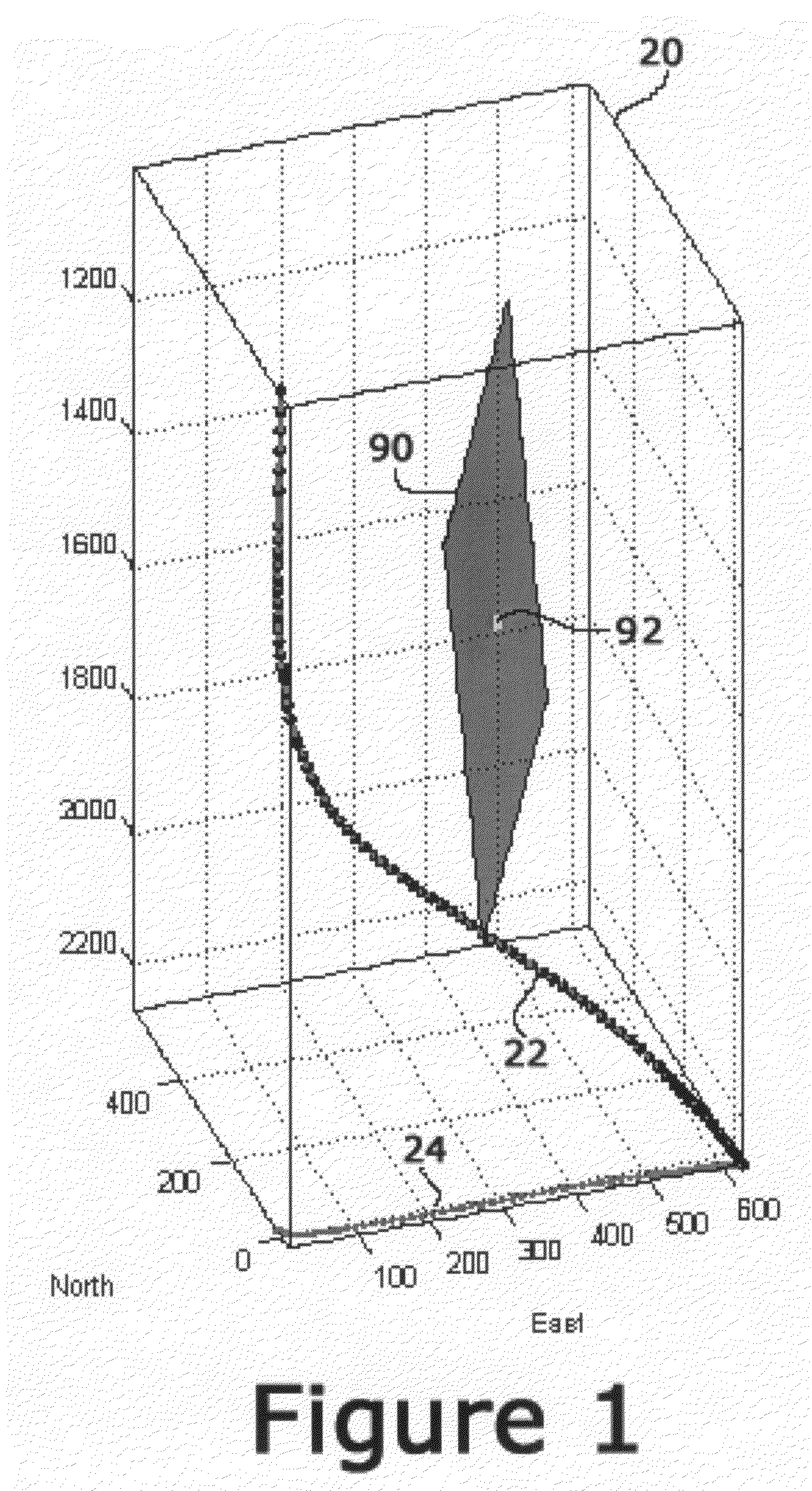
[0017]Referring to FIG. 1, there is shown a computer-generated model of a drilling operation within a volume 20. Shown in FIG. 1 is the trajectory of a borehole 22 extending through the volume 20 from a true vertical depth of 1000 m t...


PUM


Abstract

A method and system for characterization of fault conditions within a subterranean volume. In one embodiment, the system comprises means for generating a mathematical model of stress conditions within the volume, from which breakout conditions along a borehole trajectory can be predicted. The system further comprises means for sensing actual breakout conditions along a borehole extending through the volume. Predictive breakout data is compared with the actual sensed breakout conditions to assess the degree of correlation between the predictive data and the actual data, and thus the accuracy of the stress model. Means are provided for enabling a user to cause the mathematical model to be revised to reflect the presence of at least one active fault plane in the volume, where the presumed fault plane is not intersected by the borehole. The revised model is used to generate new predictive breakout data. The process of revising the stress model and assessing the correlation between predictive breakout conditions derived from the model and actual breakout conditions is repeatable in an iterative fashion to achieve an optimal correlation and hence an optimally accurate stress model reflecting fault conditions in the vicinity of but not necessarily penetrated by the borehole.

Description

FIELD OF THE INVENTION[0001]The present invention relates generally to hydrocarbon exploration and production, and more particularly relates to a method and apparatus for characterization of features in the vicinity of boreholes.BACKGROUND OF THE INVENTION[0002]Those of ordinary skill in the art will appreciate the challenges involved in imaging and identifying subterranean tectonic features that are proximal to, but not necessary penetrated by, a borehole. Characterization of subsurface features typically relies either upon a remote sensing imaging application (for example, approaches employing seismic exploration techniques and / or measurement of electrical potential fields), or upon direct sampling, i.e., drilling one or more boreholes.[0003]In general, direct sampling techniques such as the drilling of boreholes are undesirably inefficient and costly. On the other hand, remote sensing technologies and modeling techniques have been employed in the prior art with limited success, a...

Claims


Application Information

Patent Timeline
Patent Type & Authority Applications(United States)
IPC IPC(8): G06F19/00
CPCG01V1/50E21B49/006
Inventor CASTILLO, DAVID A.PESKA, PAVELMOOS, DANIEL
Owner GEOMECHANICS INT
Why Eureka
Try Eureka