Multipath Processing for GPS Receivers

a multi-path processing and receiver technology, applied in the field of spread spectrum receivers, can solve the problems of limited acceptance, difficult maintenance of continuous reception from 4 gps satellites, increased complexity and cost of such combined systems, etc., and achieve the effect of reducing the multi-path

Inactive Publication Date: 2008-08-28
KOHLI SANJAI +1
View PDF2 Cites 22 Cited by
  • Summary
  • Abstract
  • Description
  • Claims
  • Application Information

AI Technical Summary

Benefits of technology

[0022]In another aspect, the present invention provides an improved technique for multipath signal processing by tracking received GPS signals in a plurality of satellite specific channels, tracking a prompt code delay representing a direct path signal in each channel by evaluating correlation products at adjacent code delays and reducing multipath effects by evaluating correlation products at other code delays.

Problems solved by technology

Because continuous reception from 4 GPS satellites is often difficult to maintain in a car navigation environment, and known clock and altitude hold techniques can only permit operation with at least 2 satellites, known conventional car navigation systems have typically augmented the GPS position information with information from external sensors to provide dead reckoning information.
However, the resultant increased complexity and costs for such combined systems have limited their acceptance.
GPS systems, as well as many other radio frequency (RF) communication systems utilizing frequencies high enough to be considered line of sight systems in which there must be a substantially direct line of sight between the transmitter(s) and receivers(s) for optimum operation, often suffer from multipath effects in which the receiver(s) must process signals received over a multiplicity of different paths.
The multiplicity of signals being received results from additional, typically unwanted, signal paths including one or more reflections.
Multipath signals present a problem in systems, such as GPS systems, in which the time of arrival of the signal is to be measured or used because the time of arrival of the multipath signals depends on the length of the path(s) taken.
The straightforward processing of all signals, including multipath or reflected signals, often degrades the processing, performed by the receiver.
In the simple broadcast TV transmission system described above, the processing of unmodified multipath signals by the receiver results in the commonly experienced degradation called “ghosting” in which multiple signals are displayed offset in the TV image.
In other types of systems, such as the GPS systems using PRN encoded spread spectrum signals, certain conventional techniques are difficult or impossible to use.
This makes a highly directional antenna system almost completely unusable.
Multipath processing techniques currently used for complex receivers, such as GPS receivers, are often quite complex and subject to inaccuracies.
This technique of comparing processed and estimated correlation power, is complex and may be subject to error in that the partially processed signals relied on are themselves subject to degradation from many effects in addition to multipath effects including receiver limitations, which may reduce the accuracy or effectiveness of the multipath processing techniques.

Method used


Image

  • Multipath Processing for GPS Receivers
  • Multipath Processing for GPS Receivers
  • Multipath Processing for GPS Receivers

Examples


Embodiment Construction

)

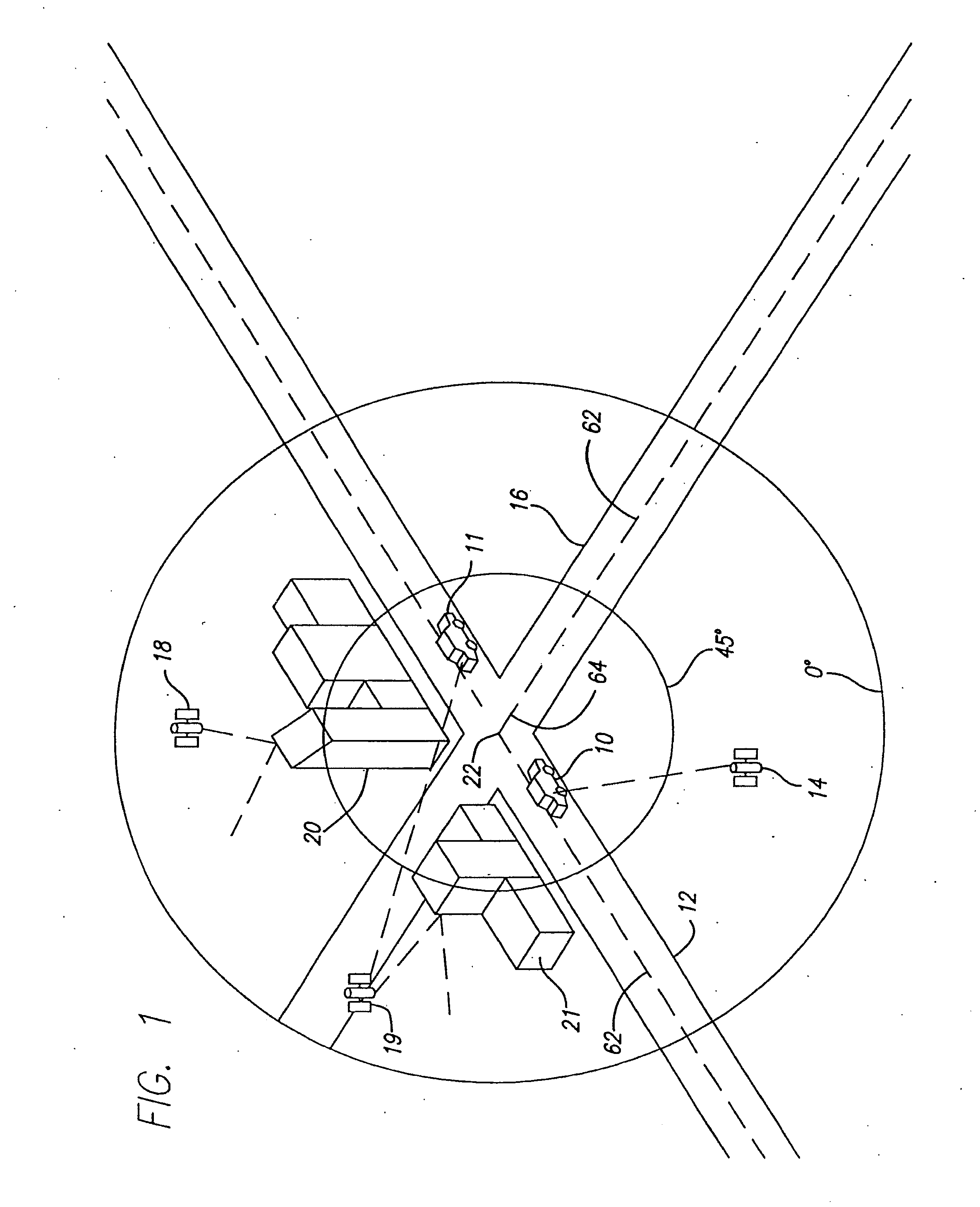
[0047]FIG. 1 is an overview illustration of the operation of a GPS car navigation system according to the present invention. The GPS car navigation system, described below in greater detail with respect to FIG. 2, is mounted in car 10 which is moving along the center of roadway 12. NAVSTAR satellite 14, in the lower left quadrant of the figure, is in view of car 10. A simulated GPS circular overhead display, positioned approximately over intersection 22 of roadway 12 and roadway 16 indicates that satellite 14 is between 0° and 45° degrees of elevation above the horizon as viewed from car 10.

[0048]For the purposes of illustration, satellite 18 is positioned overhead between the elevation angles of 0° and 45° degrees. However, the line of sight between satellite 18 and car 10 is obscured by buildings 20 so that satellite 18 is not in view of car 10 at the position along roadway 12 as shown. Similarly, the line or sight between satellite 19 and car 10 is obscured by buildings 21. Howe...


PUM


Abstract

A GPS receiver system determines the presence of trackable signals at code delays less than the prompt delay being tracked for a particular signal and changes the prompt delay to correspond to the smallest code delay having a trackable signal. Trackable signals at large code delays are multipath signals and may be separately tracked to aid in dead reckoning. The trackable signals at code delays not adjacent to the current tracked prompt delay may be tracked in the same channel as the prompt delay so that all satellite channels are continuously evaluated for multipath signals being tracked or a non-satellite specific channel may be used to sequentially step through the satellite signals to evaluate multipath on a satellite by satellite basis.

Description

RELATED APPLICATIONS[0001]This is a continuation of application Ser. No. 09 / 778,269, filed Feb. 6, 2001 which is a continuation of application Ser. No. 09 / 049,306, filed Mar. 28, 1998, now U.S. Pat. No. 6,249,542 which claims the benefit of application Ser. No. 60 / 042,868, filed Mar. 28, 1997.BACKGROUND OF THE INVENTION[0002]1. Field of the Invention[0003]This invention relates in general to spread spectrum receivers and in particular to GPS navigation systems, such as those used in terrestrial navigation for cars, trucks and other land vehicles, operated in environments with substantial multipath interference.[0004]2. Description of the Prior Art[0005]Car navigation is conventionally performed using highway and street maps aided, to some degree, by distance measurements from external sensors such as odometers. Improvements over the last 10 years in Global Positioning System, or GPS, satellite navigation receivers has spawned several GPS car navigation systems.[0006]Conventional GPS...

Claims


Application Information

Patent Timeline
Patent Type & Authority Applications(United States)
IPC IPC(8): H04B1/707G01S19/30G01C21/26G01C22/00G01S1/00G01S5/14G01S19/34G01S19/47G01S19/48G01S19/50H04B1/7085H04B1/7115H04B7/216
CPCG01C21/26G01C22/00G01S19/11G01S19/22G01S19/29G01S19/30H04B2001/70706G01S19/37G01S19/47H04B1/707H04B1/7085H04B1/7115H04B7/216G01S19/34
Inventor KOHLI, SANJAICAHN, CHARLES R.
Owner KOHLI SANJAI
Why Eureka
Try Eureka