Navigation system and method using modulated celestial radiation sources

a celestial radiation and navigation system technology, applied in the direction of reradiation, navigation instruments, instruments, etc., can solve the problems of only being accurate to a finite angular accuracy, affecting the trajectory of the vehicle, and increasing the error in navigational data

Active Publication Date: 2009-01-15
UNIV OF MARYLAND
View PDF18 Cites 41 Cited by
  • Summary
  • Abstract
  • Description
  • Claims
  • Application Information

AI Technical Summary

Problems solved by technology

Although this system requires no active hardware on the spacecraft itself, it does require an extensive ground tracking system and careful analysis of the measured data against an electromagnetically noisy background environment.
However, vehicle maneuvers or any unaccounted-for disturbances will affect the trajectory of the vehicle.
As the spacecraft moves further away from Earth observation stations, the error in navigational data increases.
However, even with this precise knowledge, the position measurement can only be accurate to a finite angular accuracy.
As the vehicle gets more distant, any fixed angular uncertainty reduces the knowledge of vehicle position, especially in the two transverse axes relative to the range direction.
Even utilizing interferometry, using the difference between multiple signals compared at two ranging stations, the angular uncertainty rapidly grows above acceptable limits.
Although improvements in the radial direction range and range-rate measurements are made utilizing such system, transverse axes, including along-track and cross-track axes, errors still exist, and this m

Method used


Image

  • Navigation system and method using modulated celestial radiation sources
  • Navigation system and method using modulated celestial radiation sources
  • Navigation system and method using modulated celestial radiation sources

Examples


Embodiment Construction

I. Overview

[0039]The present invention is now described with reference to the Drawings. In the Figures, like elements are annotated with like numerals and descriptors.

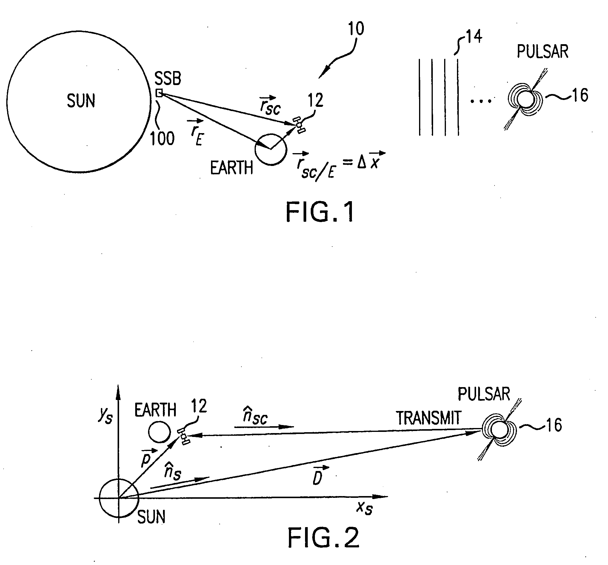
[0040]Referring to FIG. 1, there is illustrated an exemplary system 10 for absolute and relative position determination using celestial radiation sources in accordance with the present invention. As used herein, a “celestial source” refers to a natural (not man-made) celestial body emitting radiation.

[0041]As is shown in the Figure, a spacecraft, satellite or other vehicle 12 is positioned near Earth within the Solar System, as indicated by the position vector rSC / E. The location of the Earth relative to the Solar System Barycenter (SSB) is rE and the location of the spacecraft 12 relative to the SSB is rSC. The spacecraft 12 is operable to receive modulated radiation, such as pulsed radiation 14, generated by a celestial body, such as pulsar 16. The modulated radiation is subsequently used to generate navigational inf...


PUM


Abstract

A system and method for navigation utilizes sources of modulated celestial radiation. A spacecraft, satellite, or other vehicle (12) has one or more modulated radiation sensors (22a-22x) mounted thereto for detecting a modulated signal (14) generated by one or more pulsars or other celestial objects (16). A timer (24) measures the pulse time of arrival at a respective pulse sensor (22a-22x) by comparing the pulse signal (14) with a known pulse profile, and a processor (30) calculates a timing difference between the measured pulse time of arrival at sensor (22a-22x) with a calculated pulse time of arrival at a selected reference point (100). The positions and pulse profile characteristics of the pulsars (16) are stored in a digital memory (34) and combining the calculated time difference with the known positions of pulsars (16), the navigational parameters, such as position, velocity, and attitude, for spacecraft (12) with respect to the selected localized reference point (100) can be calculated.

Description

BACKGROUND OF THE INVENTION[0001]1. Field of the Invention[0002]The subject invention relates to a system and method for determining the absolute and relative position, velocity and attitude of a vehicle, such as a spacecraft or a terrestrial vehicle, utilizing modulated radiation emitted by various celestial sources. In particular, the present invention directs itself to a mobile receiver for detecting signals generated by celestial sources of modulated radiation. The mobile receiver may be mounted on a spacecraft, satellite, planetary rover, or other vehicle, and the received signal is used to calculate navigational data for the vehicle. More particularly, this invention directs itself to a clock or timer in communication with the mobile receiver for generating a timing signal corresponding to the reception and detection of the modulated celestial radiation. The timing signal is used to calculate a time difference between predicted and measured reception of the timing signal at th...

Claims


Application Information

Patent Timeline
IPC IPC(8): G01C21/02
CPCG01C21/02G01S11/12G01S5/16
Inventor SHEIKH, SUNEEL
Owner UNIV OF MARYLAND
Why Eureka
Try Eureka