Method for processing a satellite image and/or an aerial image

a satellite image and aerial image technology, applied in the field of processing satellite images and/or aerial images, can solve the problems of not being very meaningful, feeling of uneasiness in regard to driving over virtual obstacles, and obscuring the image of the front of the business,

Active Publication Date: 2010-03-25
VOLKSWAGEN AG
View PDF7 Cites 16 Cited by
  • Summary
  • Abstract
  • Description
  • Claims
  • Application Information

AI Technical Summary

Benefits of technology

[0003]Example embodiments of the present invention provide a method for processing a satellite image and/or an aerial image by w

Problems solved by technology

If this were not done, when using the unprocessed satellite images and/or aerial images for producing photo-realistic maps for navigation systems in vehicles, there would be a feeling of uneasiness with regard to driving over these virtual obstacles.
In doing so, the driver of the motor vehicle may take into account whether a corresponding ground-level photo is or would be useful at the given instant of reaching the geographical position of the object, which, for example, is not the case when, e.g., an object in the form

Method used


Image

  • Method for processing a satellite image and/or an aerial image
  • Method for processing a satellite image and/or an aerial image
  • Method for processing a satellite image and/or an aerial image

Examples


Embodiment Construction

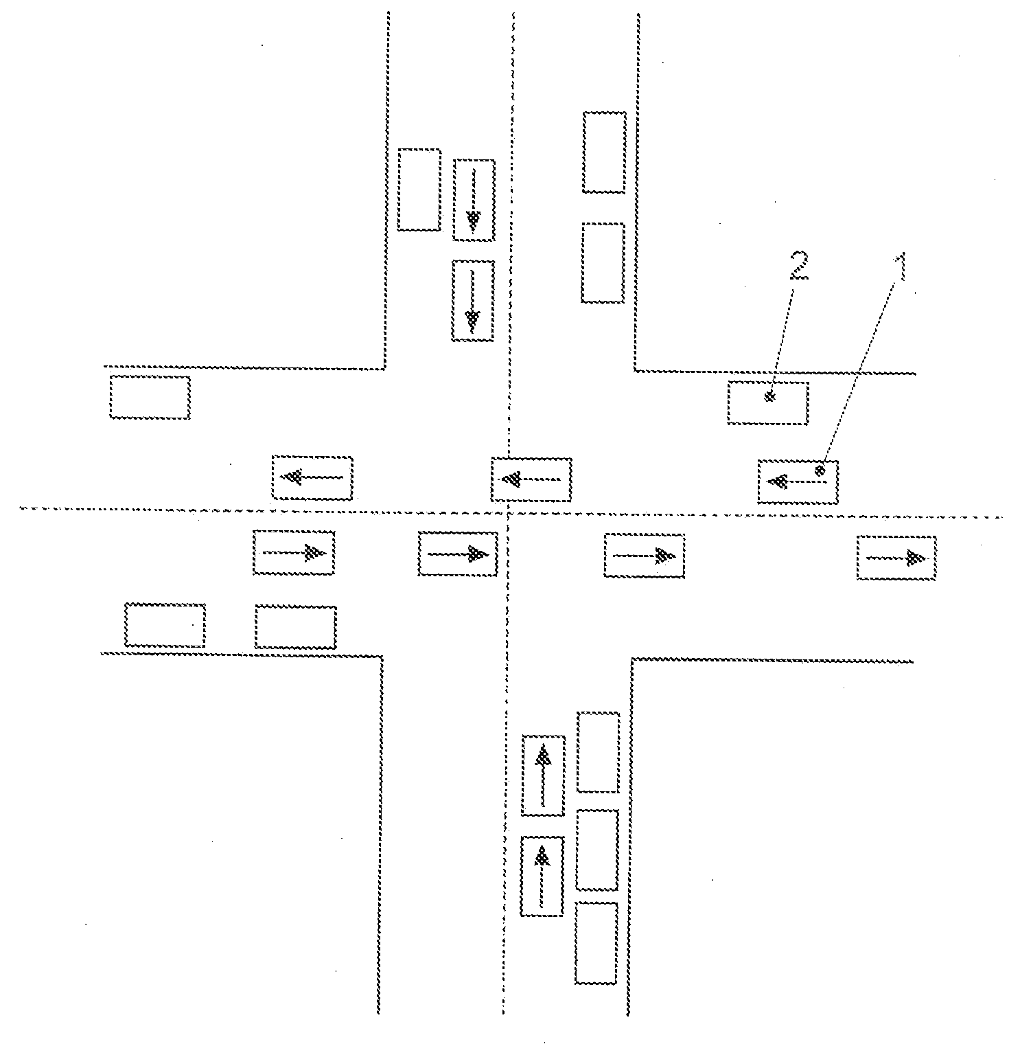
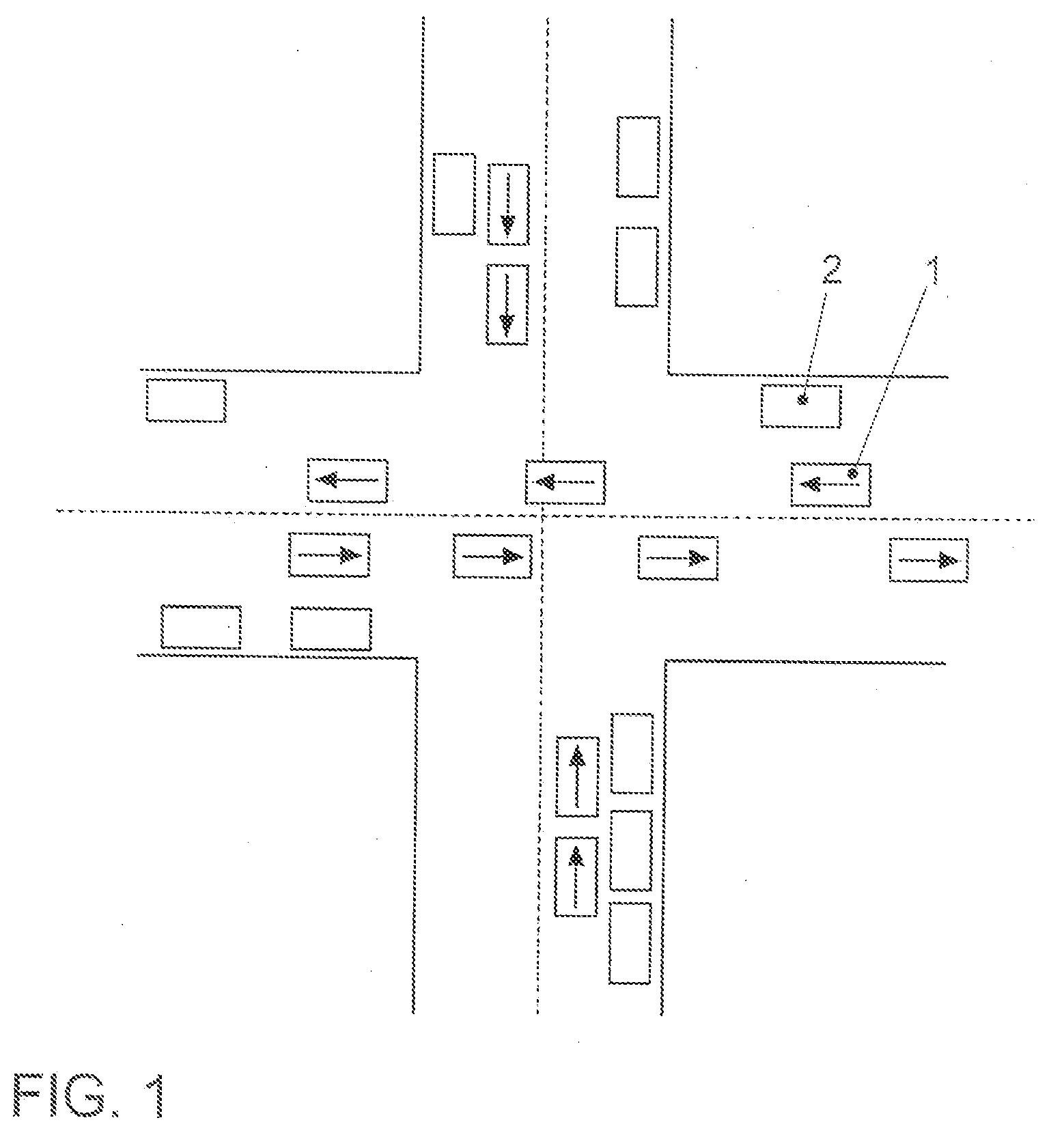
[0036]FIG. 1 schematically illustrates an exemplary embodiment of a satellite image and / or aerial image of an intersection. At the instant this satellite image and / or aerial image is photographed, both moving vehicles 1 and parked vehicles 2 are in the area of the intersection. If such a satellite image and / or aerial image were to remain unprocessed and made available in the form shown to a navigation system of a motor vehicle for displaying photo-realistic maps, then when passing through the intersection, the impression would be conveyed via the navigation system of running over moving motor vehicles 1 and / or parked vehicles 2. Moreover, superimposing such an unprocessed satellite and / or aerial image with, for example, a current traffic status would be very bewildering, since further vehicles would be displayed in addition to motor vehicles 1 and 2 already present in FIG. 1, which would lead to a very confusing display that would demand unsuitably high attention from a driver of a ...


PUM


Abstract

In a method for processing a satellite image and/or aerial image, unwanted objects are able to be removed from the satellite image and/or aerial image. Geographical positions of objects pictured in the satellite and/or aerial image are determined, at least one photo is taken at ground level at each and/or in the respective immediate vicinity of the geographical positions determined, and these photos taken at ground level are superimposed on the satellite image and/or aerial image.

Description

FIELD OF THE INVENTION[0001]The present invention relates to a method for processing a satellite image and / or an aerial image.BACKGROUND INFORMATION[0002]Satellite images and / or aerial images show the surface of the earth at the instant at which they were taken. For this reason, the satellite and / or aerial image may contain information that is unwanted and not up-to-date, which must be filtered out of the satellite images and / or aerial images depending on their use. In particular, the use of satellite images and / or aerial images for producing photo-realistic maps for navigation systems in vehicles requires that obstacles such as vehicles, trees, etc., which are present in satellite images and / or aerial images when they are taken, be filtered out. If this were not done, when using the unprocessed satellite images and / or aerial images for producing photo-realistic maps for navigation systems in vehicles, there would be a feeling of uneasiness with regard to driving over these virtual ...

Claims


Application Information

Patent Timeline
IPC IPC(8): G06K9/36
CPCG06K9/00637G06V20/176
Inventor DIAZ, LUIS SAMPEDROROSARIO, DANIEL
Owner VOLKSWAGEN AG
Why Eureka
Try Eureka