Apparatus for generating high resolution surface topology map using surface profiling and surveying instrumentation

a technology of surface topology and surface profiling, applied in the direction of instruments, navigation instruments, using reradiation, etc., can solve the problems of inability to function in the area of overhead cover (wooded areas), general inferior vertical or z-direction accuracy, and gps information

Active Publication Date: 2010-08-05
SURFACE SYST & INSTR
View PDF2 Cites 8 Cited by
  • Summary
  • Abstract
  • Description
  • Claims
  • Application Information

AI Technical Summary

Benefits of technology

[0013]The present invention is directed to an apparatus for generating a high-resolution surface topology map of a surface using surface profiling data combined with data collected from a surveying instrument. The apparatus includes an profiling device that is configured to receive a plurality of survey sample points and collecting a plurality of profile sample points of the surface. Computer hardware associated with the profiling device correlates the profile sample points with respect to the survey sample points in the Z direction. Once the correlation is performed, the correlated sample points are merged or “filled-in” by the computing hardware between the survey sample points. The high-resolution surface topology map is generated from the merging of the survey and profile sample points. In various embodiments, the survey data may be generated using an inertial profiler, an inclinometer based walking device, or a rolling-reference type profile device.

Problems solved by technology

One disadvantage of conventional total stations is that they require a line of site between the base station and the prism at the point to be surveyed.
The disadvantage of GPS information, however, is generally inferior accuracy in the vertical or Z direction.
A disadvantage of both GPS and VRS systems is their inability to function in areas of overhead cover (wooded areas, urban areas, inside buildings, etc.), where clear access to the GPS satellite is either partially or fully blocked.
Inertial profiling systems, however, do not generate a true profile since they do not record absolute elevation readings in the Z dimension, as do RTK or total stations surveying instruments.
Thus while an inertial profiling system can accurately detect the changes in the surface profile contour between points A and B on a given road surface, they cannot detect the absolute change in elevation from point A to point B.
While the resolution of both total stations and RTK surveying devices is sufficient for some applications, the resolution of these devices alone is not adequate or optimal for other applications, such as high tolerance surface design, construction project progress monitoring, or precision machine control, where a highly accurate and more resolute surface topology is desirable.

Method used


Image

  • Apparatus for generating high resolution surface topology map using surface profiling and surveying instrumentation
  • Apparatus for generating high resolution surface topology map using surface profiling and surveying instrumentation
  • Apparatus for generating high resolution surface topology map using surface profiling and surveying instrumentation

Examples


Embodiment Construction

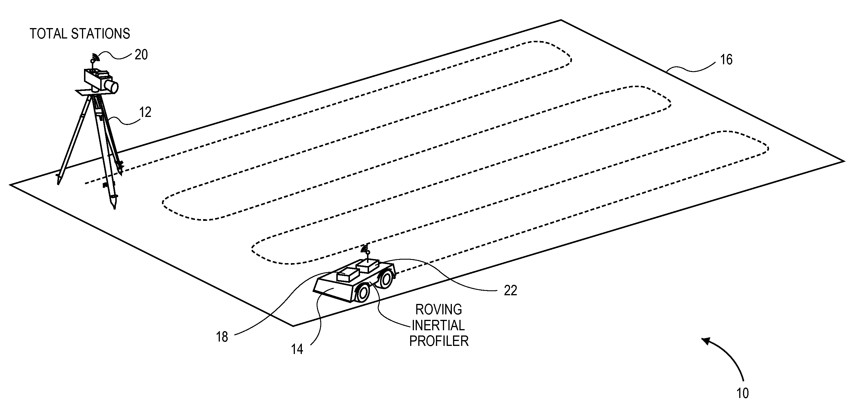
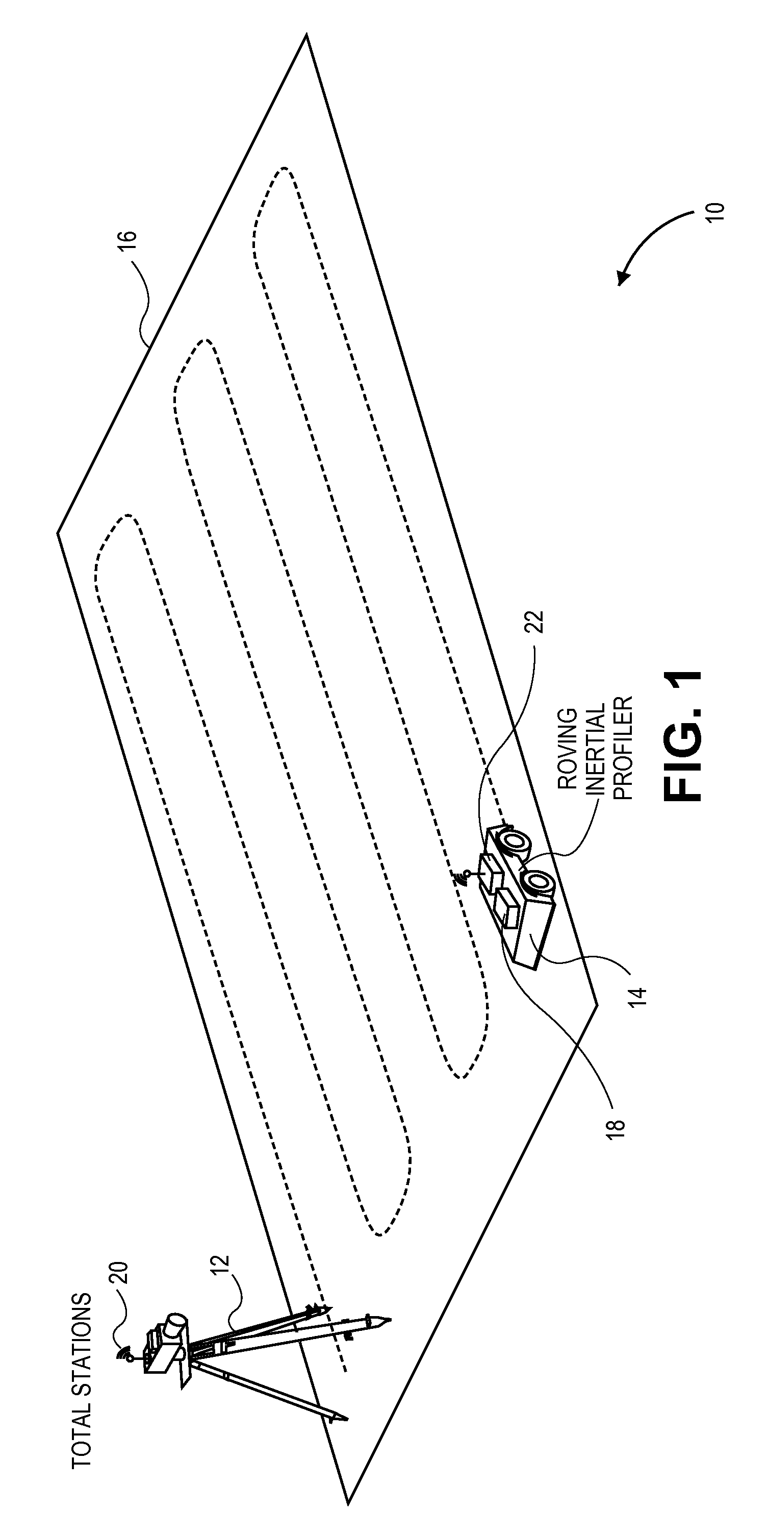
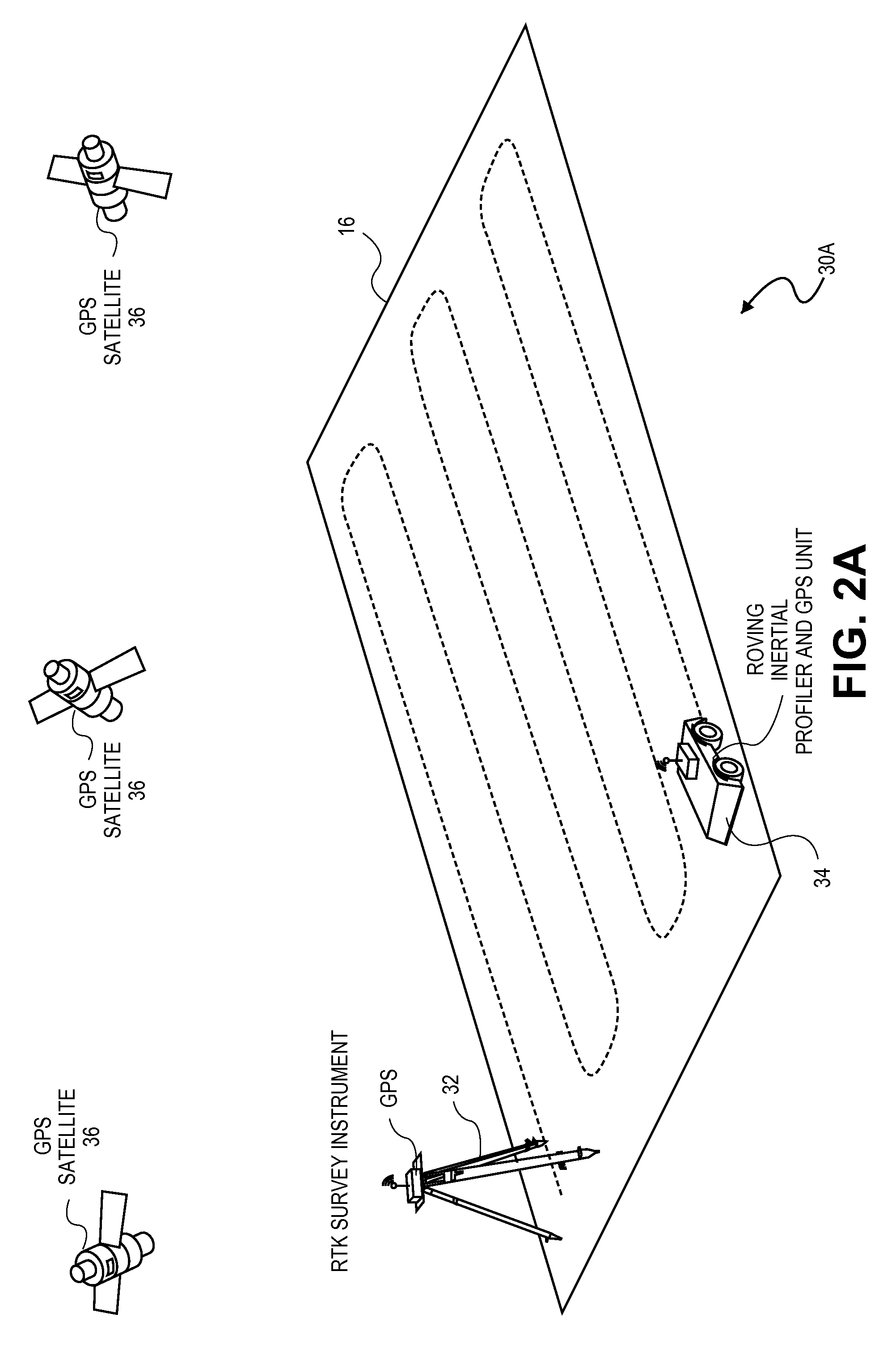
[0027]The present invention is directed to a high-resolution surface topology measurement apparatus and method that uses data collected from both an inertial profiling system and a surveying instrument, such as either a total stations system or an RTK system that uses either GPS or VRS. With data from the inertial profiling system sampling at a much finer interval than either surveying instrument, the “gaps” between the survey instrument sample points can be “filled-in” with the finer or higher resolution inertial profiler sample points. The inertial data points are then mathematically height-correlated with the true elevation readings from survey instrument. As a result, the gaps between the survey sample points are “filled-in” with the correlated inertial profile data points, resulting in a denser, higher resolution, more accurate three-dimensional map of the measured surface terrain compared to the same when generated by just a total station or RTK survey instrument alone.

[0028]F...


PUM


Abstract

A profiling apparatus configured to generate a high-resolution surface topology map of a surface using surface profiling data combined with surveying data. The apparatus is configured to collect both a plurality of survey sample points and a plurality of profile sample points of the surface. The profile sample points are then correlated with the survey sample points in the Z direction. Once the correlation is performed, the correlated profile sample points are merged or “filled-in” between the survey sample points. The high-resolution surface topology map is generated from the merging of the survey and profile sample points. In various embodiments, the survey data may be generated using an inertial profiler, an inclinometer based walking device, or a rolling-reference type profile device.

Description

CROSS REFERENCE TO RELATED APPLICATIONS[0001]The present application claims priority to U.S. Provisional Patent Application Ser. No. 61 / 149,227, entitled “Method and Apparatus for Generating High Resolution Surface Topology Maps Using Inertial Profiling and Surveying Instrumentation,” filed Feb. 2, 2009, and incorporated by reference herein for all purposes.BACKGROUND[0002]1. Field of the Invention[0003]This invention pertains to an apparatus for generating high resolution surface topology maps, and more particularly, to an apparatus for generating high resolution surface topology maps using surface profiling data combined with data collected from a land surveying instrument, such as either a total station or a Global Positioning System with Real Time Kinemetic (RTK) surveying device, such as a Carrier-Phase Enhancement GPS System (CPGPS) using a single reference station or a Virtual Reference Station (VRS) using a group of networked reference stations.[0004]2. Description of Relate...

Claims


Application Information

Patent Timeline
Patent Type & Authority Applications(United States)
IPC IPC(8): G06F19/00
CPCG01C21/165G01C15/00G01C21/1652
Inventor SCOTT, DENNIS P.DAY, DWIGHT D.
Owner SURFACE SYST & INSTR
Why Eureka
Try Eureka