Monitoring system using unmanned air vehicle with wimax communication

a technology of wimax communication and monitoring system, which is applied in vehicle position/course/altitude control, process and machine control, instruments, etc., can solve the problems of inability to capture images of a wide area, inability to use this method, and high installation cost and maintenance difficulty, so as to achieve high-speed long-distance transmission and expand the transmission period

Inactive Publication Date: 2011-01-13
JCASTNETWORKS
View PDF3 Cites 36 Cited by
  • Summary
  • Abstract
  • Description
  • Claims
  • Application Information

AI Technical Summary

Benefits of technology

[0022]A monitoring system using an air vehicle with WiMAX communication according to the present invention provide following effects.
[0023]At first, the monitoring system according to the present invention enables real-time and instant tracking and monitoring of images captured by the air vehicle and corresponding location information thereof per a unit time by capturing on-scene image information of a target monitoring area and obtaining corresponding GPS information thereof using the air vehicle having a photographing unit and a GPS receiver and transmitting the on-scene image information and the GPS information to a relay unit at a remote location in real time using a WiMAX communication scheme. The monitoring system according to the present invention also enables an instant countermeasure for a disaster by immediately dispatching emergency rescuers when a predetermined disaster is occurred in a corresponding area.
[0024]Secondly, the monitoring system according to the present invention secures enough wireless transmission period and supports high speed long distance transmission by using a WiMAX communication scheme. Particularly, the monitoring system according to the present invention can be vary useful if it is required to immediately transmit information in an urgent environment where needs an emergency rescue operation.
[0025]Thirdly, the monitoring system according to the present invention can advantageously maintains link between the relay unit and the air vehicle using a pan tilting module disposed at the relay unit.
[0026]Fourthly, the monitoring system according to the present invention can overcome obstacles of radio wave propagation paths and further expand a transmission period by including an additional relay unit between the air vehicle and the relay unit or between the relay unit and an external disaster prevention center.

Problems solved by technology

According to the monitoring method according to the related art, the monitoring area is restrictive and it is impossible to capture images of a wide area because a camera captures images of an only area limited by the installation location of the camera.
Such a monitoring method using the plurality of cameras has shortcomings of a high installation cost and a maintenance difficulty.
Particularly, if a target monitoring area is very wide such as mountains, seashore, valley, and a military area, it is almost impossible to use this method due to the number of cameras required.
In case of using cables to transmit the captured image data, it is very difficult to install the cables due to the wide monitoring area.
Also, it requires a high installation cost.
In case of using a wireless route such as radio frequency (RF), it is difficult to transmit the large amount of data and to maintain the wireless routes because the number of wireless routes increases corresponding to the number of cameras.
Also, the number of allocated channels is limited, and a transmission distance and a transmit rate are limited.
Meanwhile, various disasters, such as flood, fire, damages by blight and harmful insects, and detection of a vehicle in a vehicle restricted area, may be happened in mountains, seashore, a military area, and a vehicle restricted area.
However, there was a limitation to instantly and accurately report information on the disaster area and the current state thereof by words of mouth using the communication device.
Accordingly, a national emergency management agency could not easily analyze the current state of the disaster location and had difficulties to immediately perform a follow-up operation such as sending out rescuers.
Finally, the damages of the disaster area were accumulated.
Since the process of dispatching the helicopter is so complicated and time consuming process, it is very difficult to effectively deal with the disasters.

Method used


Image

  • Monitoring system using unmanned air vehicle with wimax communication
  • Monitoring system using unmanned air vehicle with wimax communication
  • Monitoring system using unmanned air vehicle with wimax communication

Examples


Embodiment Construction

[0034]The advantages, features and aspects of the invention will become apparent from the following description of the embodiments with reference to the accompanying drawings, which is set forth hereinafter. Terms and words used in specification and claims must not be understood as typical or dictionary meaning only. Terms and words may be understood as meanings and concepts corresponding to technical aspects of the present invention based on the principle that inventors may properly define concepts of terms in order to describe own invention with the best method.

[0035]Therefore, embodiments described in specification and configurations shown in accompanying drawings are only an embodiment of the present invention. Since the embodiments and the configurations may not represent all of technical aspects of the present invention, there may be various equivalents and modifications which can replace the embodiments and the configuration at a time of filing a related application.
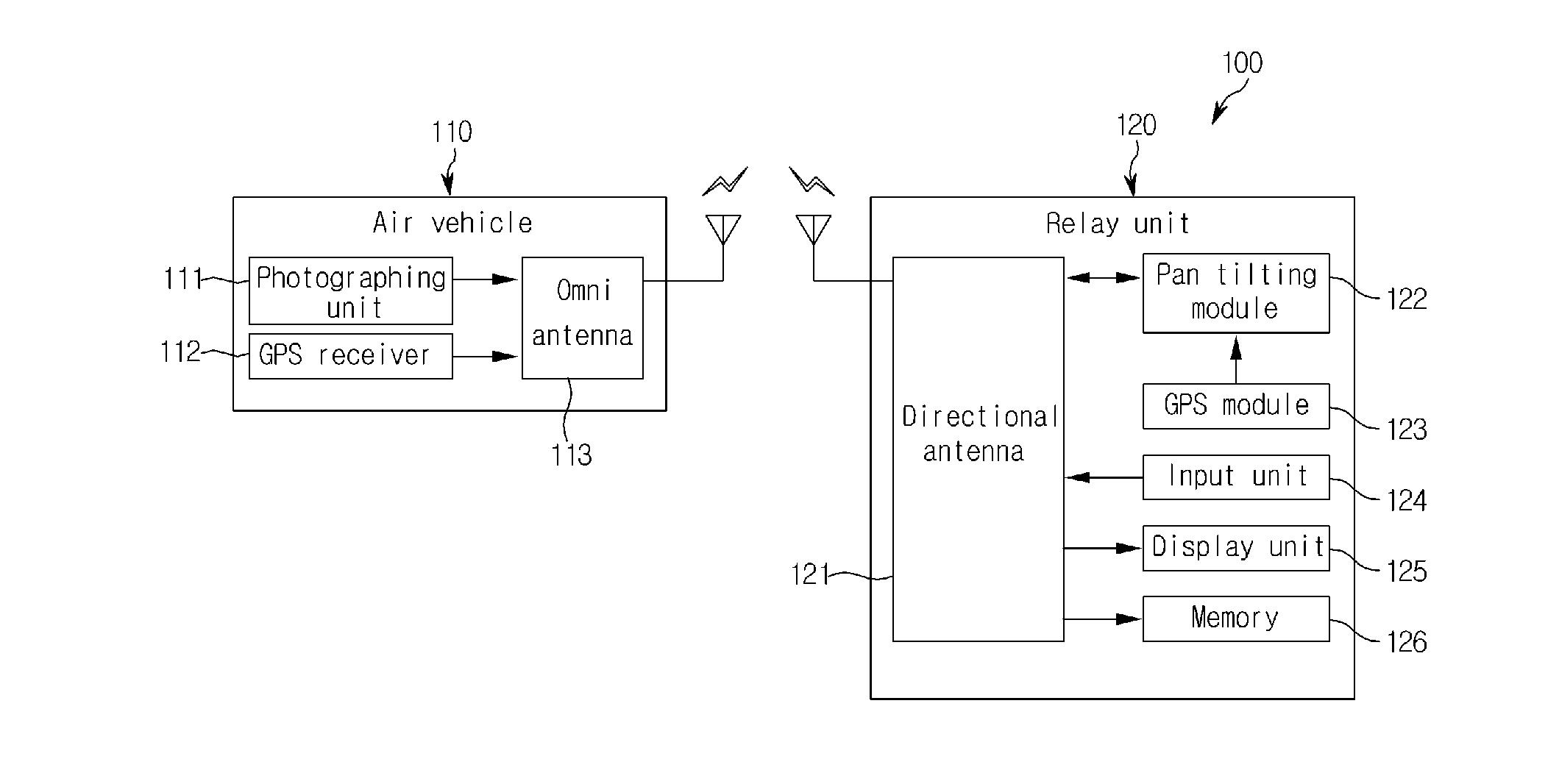
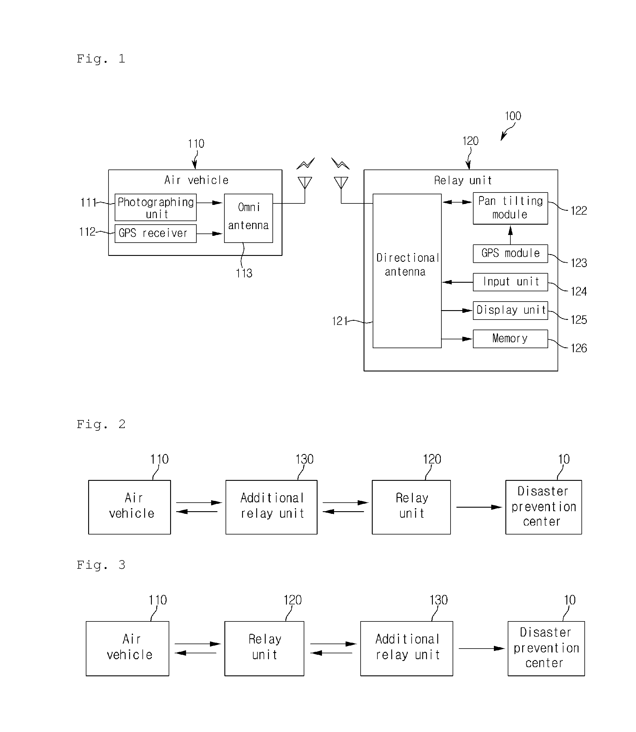
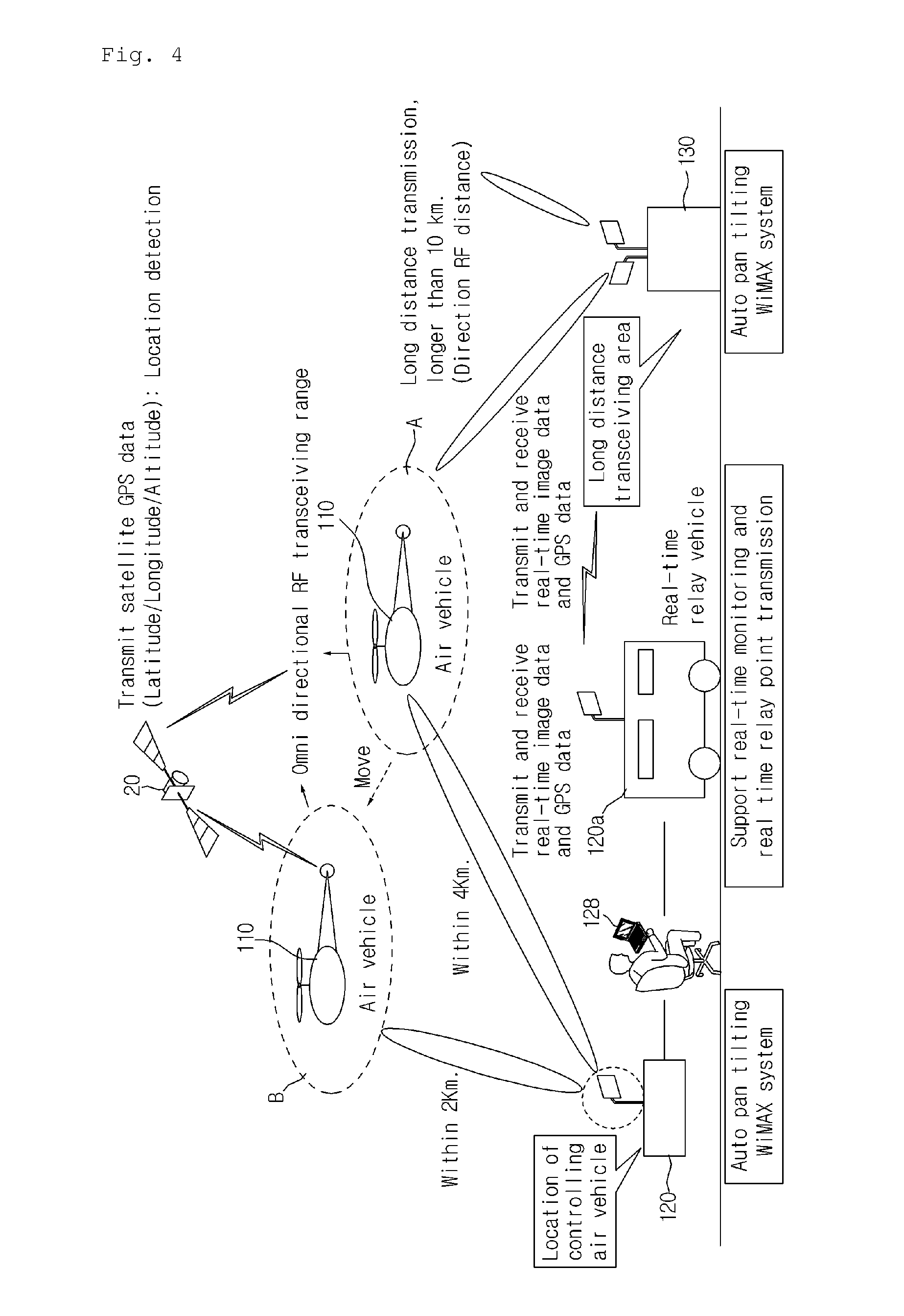
[0036]FIG...


PUM


Abstract

Provided is a monitoring system using an unmanned air vehicle communicated based on a WiMAX communication scheme. The monitoring system includes an air vehicle and a relay unit. The air vehicle includes a photographing unit for capturing on-scene image information of a current flying area, and a global positioning system (GPS) receiver for receiving GPS information of the current flying area. The air vehicle transmits the on-scene image information and the GPS information, wirelessly. The relay unit remotely controls the air vehicle by receiving a travel command signal having information on a destination of the air vehicle, wirelessly transmits the travel command signal to the air vehicle based on the WiMAX communication scheme, and wirelessly receives the on-scene image information and the GPS information from the air vehicle based on the WiMAX communication scheme.

Description

TECHNICAL FIELD[0001]The present invention relates to a monitoring system using an unmanned air vehicle with WiMAX communication and, more particularly, to a monitoring system using an unmanned air vehicle with WiMAX communication for monitoring a target area using camera image information that is transmitted in real time from an unmanned air vehicle.BACKGROUND ART[0002]As a method for monitoring an area from a remote location according to the related art, a stationary camera is disposed at a predetermined location and controlled in left and right, and up and down directions to monitor the area.[0003]According to the monitoring method according to the related art, the monitoring area is restrictive and it is impossible to capture images of a wide area because a camera captures images of an only area limited by the installation location of the camera.[0004]In order to overcome such a shortcoming, an area is divided into a plurality of sections and a plurality of cameras are disposed ...

Claims


Application Information

Patent Timeline
Patent Type & Authority Applications(United States)
IPC IPC(8): G05D1/00
CPCG01S19/39G01S5/0027G01S19/13G01C11/02
Inventor EU, JAI HONGHEO, JIN SEOK
Owner JCASTNETWORKS
Why Eureka
Try Eureka