
Signal processing techniques for improving the sensitivity of GPS receivers

a technology of signal processing and receiver, applied in satellite radio beaconing, measurement devices, instruments, etc., can solve the problem of minimum signal strength, achieve the effect of reducing the minimum signal strength, increasing the accuracy of carrier frequency, and facilitating rapid and reliable operation

Inactive Publication Date: 2011-04-07
ETHERWHERE CORP
View PDF5 Cites 5 Cited by
  • Summary
  • Abstract
  • Description
  • Claims
  • Application Information

AI Technical Summary

Benefits of technology

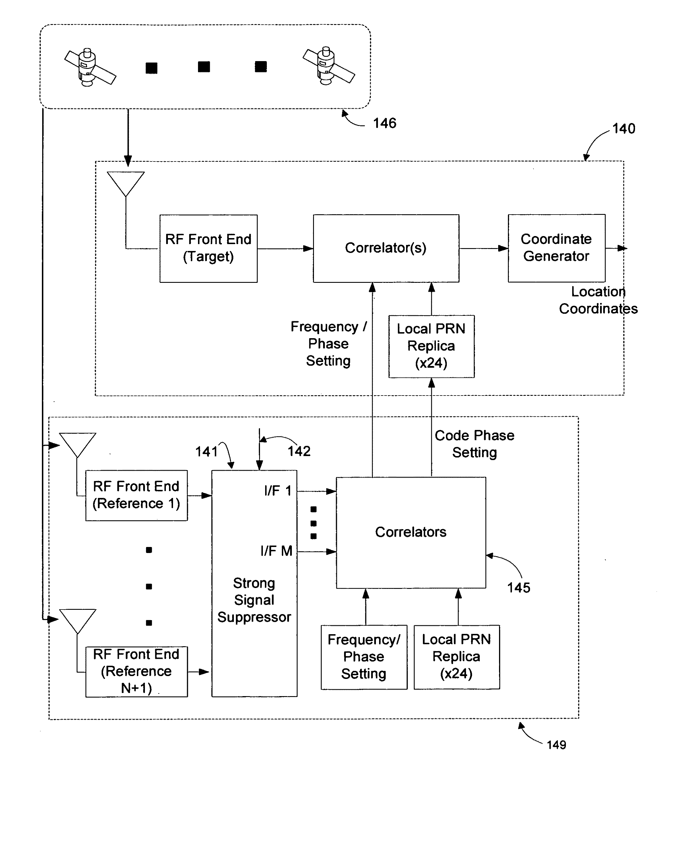
[0015]In general, the object of the present invention is to provide methods and apparatus to increase the accuracy of carrier frequency and phase as well as the PRN code phase information and decoded 50 Hz data provided by GPS assistance systems to target GPS receivers to enable more rapid and reliable operation in indoor and urban canyon environments. To the extent that the satellites electronically visible to target GPS receivers inside commercial buildings are likely to be near the horizon, where the acquisition and tracking of satellites near the horizon is peculiarly challenging for prior-art GPS assistance systems, novel techniques for reducing the minimum signal strength required by GPS assistance systems to acquire and accurately track satellites near the horizon are disclosed. The use of multiple GPS sensors provides the conceptual framework for such techniques. In this context, a GPS sensor consists of an antenna and an RF front end. To eliminate confusion, GPS sensors are characterized as one of two types: target GPS sensors, whose location is to be determined; and reference GPS sensors, used by a GPS assistance system to accurately track all satellites visible to target GPS receivers, enabling the GPS assistance system to provide accurate carrier frequency and phase as well as PRN code information to target GPS receivers, be they indoors or out.
[0016]The reduction in the minimum signal strength required by a GPS assistance system to acquire and accurately track a satellite near the horizon is obtained by mitigating the deleterious effects of strong satellite signals (typically from overhead satellites) on the tracking of weaker satellite signals (typically from satellites near the horizon). The potential for strong satellite signals to interfere in the tracking of weak satellite signals is an artifact of the correlation process which serves as the foundation for GPS satellite signal acquisition and tracking techniques.
[0021]FIG. 11 describes the application of a Strong Signal Attenuation Subsystem within a GPS assistance system. The Strong Signal Attenuation Subsystem enables the GPS assist system 119 to more precisely quantify the carrier frequency and phase as well as the code phase of signals from satellites near the horizon—owing to the fact that potentially-interfering overhead satellite signals have been suppressed in the I / F signals corresponding to satellites at or near the horizon, enabling the bank of correlators 115 to function efficiently and effectively.
[0029]strong signal attenuation means for generating one or more GPS satellite-specific I / F signals, enabling more efficient and effective acquisition of said navigation satellites;

Problems solved by technology

To the extent that the satellites electronically visible to target GPS receivers inside commercial buildings are likely to be near the horizon, where the acquisition and tracking of satellites near the horizon is peculiarly challenging for prior-art GPS assistance systems, novel techniques for reducing the minimum signal strength required by GPS assistance systems to acquire and accurately track satellites near the horizon are disclosed.

Method used


Image

  • Signal processing techniques for improving the sensitivity of GPS receivers
  • Signal processing techniques for improving the sensitivity of GPS receivers
  • Signal processing techniques for improving the sensitivity of GPS receivers

Examples


Embodiment Construction

[0053]In general, the object of the present invention is to provide methods and apparatus to increase the accuracy of carrier frequency and phase as well as PRN code phase information and decoded 50 Hz data provided by GPS assistance systems to target GPS receivers to enable more rapid and reliable operation in indoor and urban canyon environments. To the extent that the satellites electronically visible to target GPS receivers inside commercial buildings are likely to be near the horizon, even as the acquisition and tracking of satellites near the horizon is peculiarly challenging for prior-art GPS assistance systems, novel techniques for reducing the minimum signal strength required by GPS assistance systems to acquire and accurately track satellites near the horizon are disclosed. The use of multiple GPS sensors provides the conceptual framework for such techniques. In this context, a GPS sensor consists of an antenna and an RF front end. To eliminate confusion, GPS sensors are c...


PUM


Abstract

The use of multiple GPS sensors provides the conceptual framework for novel techniques for reducing the minimum signal strength required by a GPS assistance system to acquire and accurately track GPS satellites at or near the horizon. A strong signal attenuation system for synthesizing GPS satellite-specific I / F signals, enabling more efficient and effective acquisition of GPS satellites, is disclosed, comprising N+1 reference GPS sensors, each with an omni-directional antenna and front end, for down converting composite GPS satellite signals, and strong signal suppression (SSS) means for synthesizing, from the I / F signals produced by the N+1 reference GPS sensors, a set of one or more I / F signals (corresponding to a set of designated satellites), each with at least N of the strongest potentially-interfering satellite signals suppressed.

Description

CROSS-REFERENCE TO RELATED APPLICATIONS [0001]This application claims priority under 35 U.S.C. ξ 120 from co-pending U.S. Patent Applications entitled “Signal Processing Techniques for Improving the Receive Sensitivity of GPS Receivers”, filed contemporaneously.STATEMENT REGARDING FEDERALLY SPONSORED RESEARCH OR DEVELOPMENT [0002]Not ApplicableBACKGROUND OF THE INVENTION[0003]This invention relates to the determination of location coordinates of devices embodying GPS sensors.[0004]The NAVSTAR Global Positioning System (GPS) developed by the United States Department of Defense uses a constellation of between 24 and 32 Medium Earth Orbit satellites that transmit precise microwave signals, which allows devices embodying GPS sensors to determine their current location. The initial application was predominantly for military purposes, namely weapons targeting and troop deployment. The first widespread consumer based application was navigational assistance. These early applications shared ...

Claims


Application Information

Patent Timeline
Patent Type & Authority Applications(United States)
IPC IPC(8): G01S19/24
CPCG01S19/22G01S19/36G01S19/28
Inventor FARROKHI, FARROKHWONG, DICKSON T.COLLMEYER, ARTHUR J.
Owner ETHERWHERE CORP
Learn More