Software GNSS Receiver for High-Altitude Spacecraft Applications

a receiver and spacecraft technology, applied in satellite radio beaconing, measurement devices, instruments, etc., can solve the problems of incompatibility of -oriented gps receivers with next-generation communications technology, difficult process of signal acquisition, and inability to integrate coherently with other technologies, and achieve long-term integration. the effect of long-term integration

Active Publication Date: 2011-10-20
THE BOEING CO
View PDF1 Cites 30 Cited by
  • Summary
  • Abstract
  • Description
  • Claims
  • Application Information

AI Technical Summary

Benefits of technology

[0015]The present invention includes a system that provides GPS-based navigation / orbit determination capabilities for high-altitude spacecraft. The system disclosed herein uses an existing spacecraft processor and an easy-to-space-qualify minimum-hardware front end to minimize the need for new space-qualified hardware. The system also uses coherent integration (also known as “time-domain averaging”) to acquire and track the very weak GPS signals at the high altitudes typical of GEO or HEO. The system disclosed herein uses diurnal thermal modeling of a spacecraft clock and precision orbit propagation to enable longer coherent integration; a special Kalman filter to allow weak signal tracking by integrated operation of orbit determination and GPS signal tracking; and a segment-by-segment, post-processing, delayed-time approach to allow a low-speed spacecraft processor to provide the software GPS capability. The system disclosed herein also provides an efficient way of updating and utilizing GPS navigation data (“navdata”) that is used to “wipeout” the navdata on the GPS signal to allow long coherent integration.

Problems solved by technology

Signal acquisition is generally a more difficult process than signal tracking.
The signal processing and analyzing functions of a GPS receiver can be relatively complex and until recently were generally performed by customized processing hardware, such as application specific integrated circuits (ASICs).
As such, a typical hardware-oriented GPS receiver can become incompatible with next generation communications technology, and may require costly upgrading or replacement or integration with other devices.
In addition, hardware-oriented GPS receivers used in harsh environments, such as in military applications, typically require an extensive support system to maintain reliable component operation.
Conventional (GPS) receivers are generally not readily capable of operating effectively at altitudes above low Earth orbits (LEO), namely, geostationary Earth orbits (GEO) or other high-altitude space missions.
This is due, in part, to the fact that the GPS signals available at higher altitudes are much weaker and more sparsely present than on Earth or at LEO and the strongest part of the signal is mostly blocked by the earth itself.
The generally inadequate (for weak signals) conventional approach is to employ a serial search of the two-dimensional parameter (frequency and time) space during acquisition.

Method used


Image

  • Software GNSS Receiver for High-Altitude Spacecraft Applications
  • Software GNSS Receiver for High-Altitude Spacecraft Applications
  • Software GNSS Receiver for High-Altitude Spacecraft Applications

Examples


Embodiment Construction

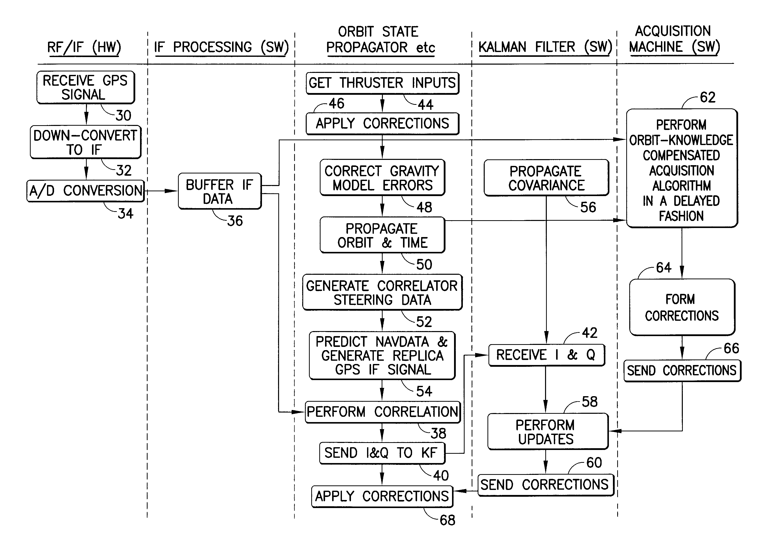
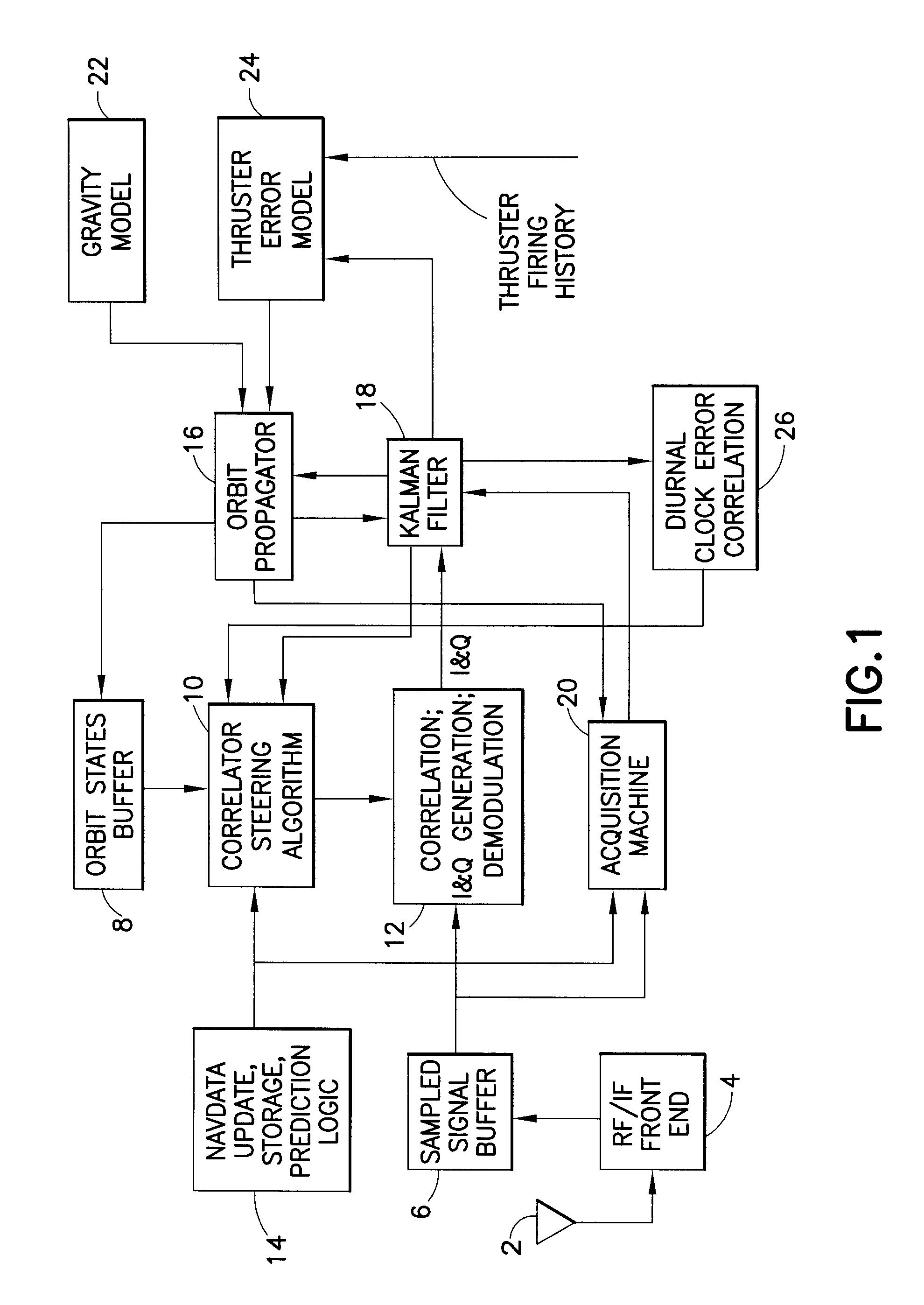
[0020]A high-altitude GPS orbit determination system in accordance with one embodiment of the invention is depicted in FIG. 1. Analog GPS signals are received by an antenna 2 onboard the orbiting spacecraft. These GPS signals are received by front-end hardware represented by block 4 in FIG. 1. This front-end hardware preferably comprises a single-chip, easily space-qualifiable solution which can be purchased in the open market. Block 4 takes the L-band GPS signal and down converts to the Intermediate Frequency (IF) band (typically a few megahertz). Block 4 then samples the analog signal using an analog-to digital (A / D) conversion at around 4 MHz (for CA code). The output of block 4 is digital data that can be processed by a computer processor onboard the orbiting spacecraft. The design and fabrication of block 4 is well known in the art of GPS.

[0021]The sampled signal (i.e., digital) data from block 4 is output to a sampled signal buffer 6, which saves the digital data. Buffer 6 can...


PUM


Abstract

A system that provides GPS-based navigation / orbit determination capabilities for high-altitude spacecraft. The system uses an existing spacecraft processor and an easy-to-space-qualify minimum-hardware front end to minimize the need for new space-qualified hardware. The system also uses coherent integration to acquire and track the very weak GPS signals at high altitudes. The system also uses diurnal thermal modeling of a spacecraft clock and precision orbit propagation to enable longer coherent integration, a special Kalman filter to allow weak signal tracking by integrated operation of orbit determination and GPS signal tracking, and a segment-by-segment, post-processing, delayed-time approach to allow a low-speed spacecraft processor to provide the software GPS capability.

Description

BACKGROUND[0001]This invention generally relates to radio navigation / communications, and more particularly relates to software GNSS receivers.[0002]Global Navigation Satellite Systems (GNSS) is the standard generic term for satellite navigation systems that provide autonomous geo-spatial positioning with global coverage. GNSS allows an electronic receiver to determine its location (longitude, latitude and altitude) to within a few meters using time signals transmitted along a line-of-sight from satellites. The global coverage is achieved by constellations of medium Earth orbit (MEO) satellites in different orbital planes.[0003]The United States NAVSTAR Global Positioning System (GPS) is a GNSS. GPS receivers are currently in widespread use for navigation and other related applications. Basically, a GPS receiver can determine its location by analyzing radio signal information received from GPS satellites orbiting the earth.[0004]Generally, GPS signal processing can be divided into tw...

Claims


Application Information

Patent Timeline
Patent Type & Authority Applications(United States)
IPC IPC(8): G01S19/37
CPCG01S19/14G01S19/46G01S19/246G01S19/23
Inventor LI, RONGSHENGGHASSEMI, KAMRANKELLEY, CLIFFORD W.
Owner THE BOEING CO
Why Eureka
Try Eureka