Probabilistic Map Matching From A Plurality Of Observational And Contextual Factors

a technology of probabilistic map matching and contextual factors, applied in surveying, navigation, instruments, etc., can solve problems such as difficulty in ensuring that mobile positions identified via gps are being properly registered on a digital map, inaccurate road, path and/or building identification by the map matching method, and gps sensor errors

Active Publication Date: 2011-12-22
MICROSOFT TECH LICENSING LLC
View PDF21 Cites 105 Cited by
  • Summary
  • Abstract
  • Description
  • Claims
  • Application Information

AI Technical Summary

Benefits of technology

Described herein are techniques for map matching utilizing probabilistic models, such as a Hidden Markov Model (“HMM”). In one embodiment, time-adjacent points at sensed locations are received and one or more routes between two of the points are identified. A relative probability of the one or more routes may be determined based on a combination of different factors. For instance, the relative probability may be based on a distance by comparing a direct “as the crow flies” distance between the two points and a total distance between the two points using each of the routes. The relative probability may also be based on time, velocity, historical information, an efficiency of a route, or a complexity of a network. In another embodiment, one or more of the identified routes may be removed if a distance between a particular point and a particular route or a distance between the direct distance and the total distance exceeds a predetermined, dynamic, or adaptive threshold. Alternatively, one or more of the identified routes may be removed if the computed probability falls below a threshold.
In another embodiment, a method describes collecting a plurality of time-adjacent points each corresponding to a particular geographic location. For each time-adjacent point, one or more candidate matches, such as route segments, in proximity to the geographic location may be identified. In this embodiment, a measurement probability that the time-adjacent points correspond to each of their respective candidate matches may be determined. Furthermore, a transition probability of moving from a first candidate match corresponding to a first-time adjacent point to a second candidate match corresponding to a second-time adjacent point may also be determined. In the above embodiment, the transition probability may be based on at least distance, time, velocity, information known about the entity or a region, efficiency of the route, the complexity of a network, or any combination thereof. In an additional embodiment, one or more sensed time-adjacent points may be deleted if a route may be predicted correctly without using the deleted points.
This Summary is provided to introduce a selection of concepts in a simplified form that is further described below in the Detailed Description. This Summary is not intended to identify key features or essential features of the claimed subject matter, nor is it intended to be used to limit the scope of the claimed subject matter.

Problems solved by technology

However, as GPS and digital maps are both prone to various errors, it is difficult to ensure that mobile positions identified via GPS are being registered properly on a digital map.
As a result, an entity having a GPS sensor may be erroneously displayed on a digital map as moving through a building or moving across a body of water, or traversing an incorrect road.
The road, path, and / or building identified by the map matching method may be inaccurate for a variety of reasons.
Therefore, for a vehicle having a GPS sensor, multiple candidate streets and measurement noise may make it difficult to determine the specific street being traversed.
Moreover, simply matching each noisy sensed location point to the nearest path or road may also result in unreasonable and unlikely routes.
If a real-time location displayed on a digital map is inaccurate, not only will a person be unaware of their respective location, but that person will also be unable to navigate to their final destination.

Method used


Image

  • Probabilistic Map Matching From A Plurality Of Observational And Contextual Factors
  • Probabilistic Map Matching From A Plurality Of Observational And Contextual Factors
  • Probabilistic Map Matching From A Plurality Of Observational And Contextual Factors

Examples


Embodiment Construction

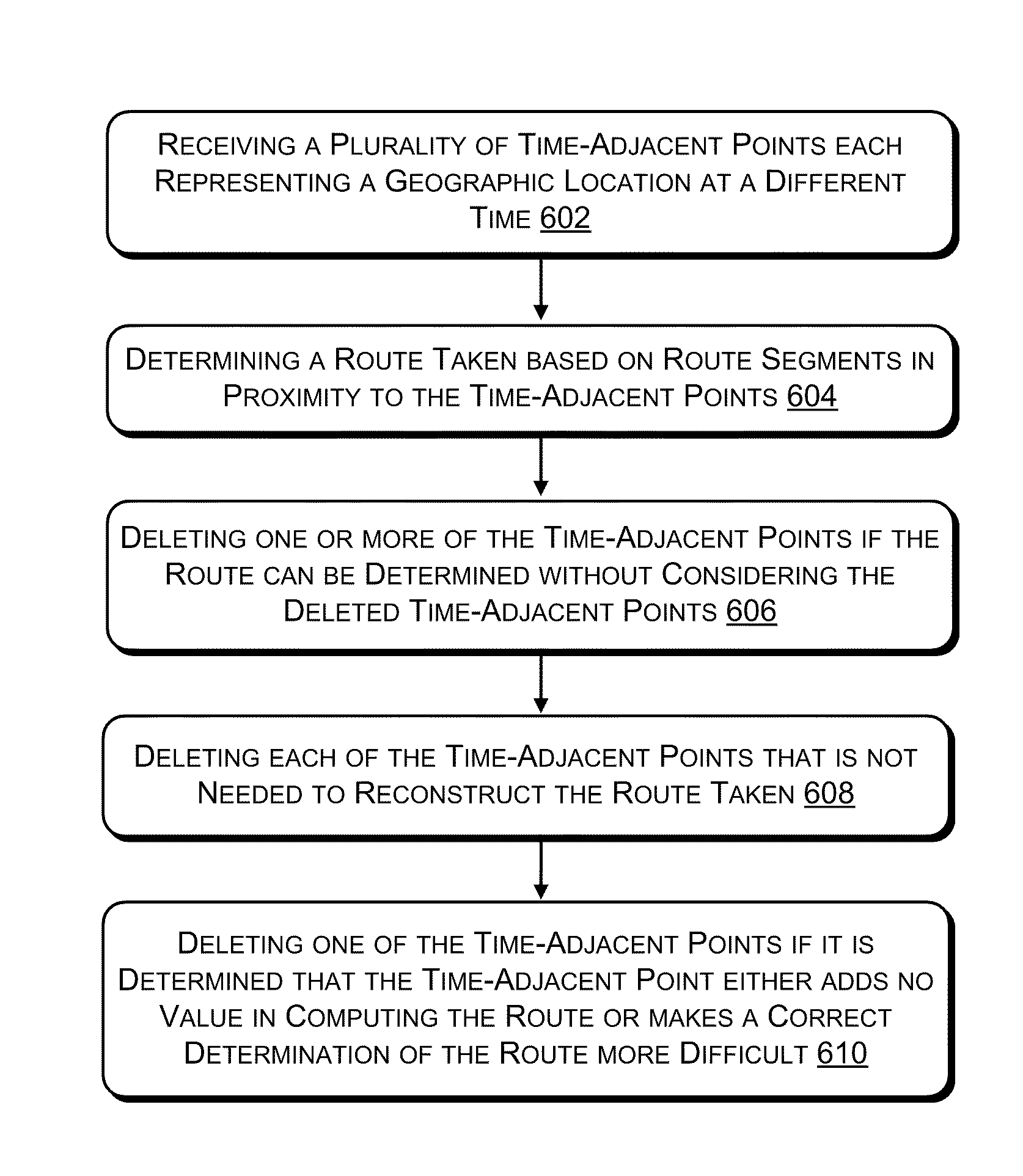
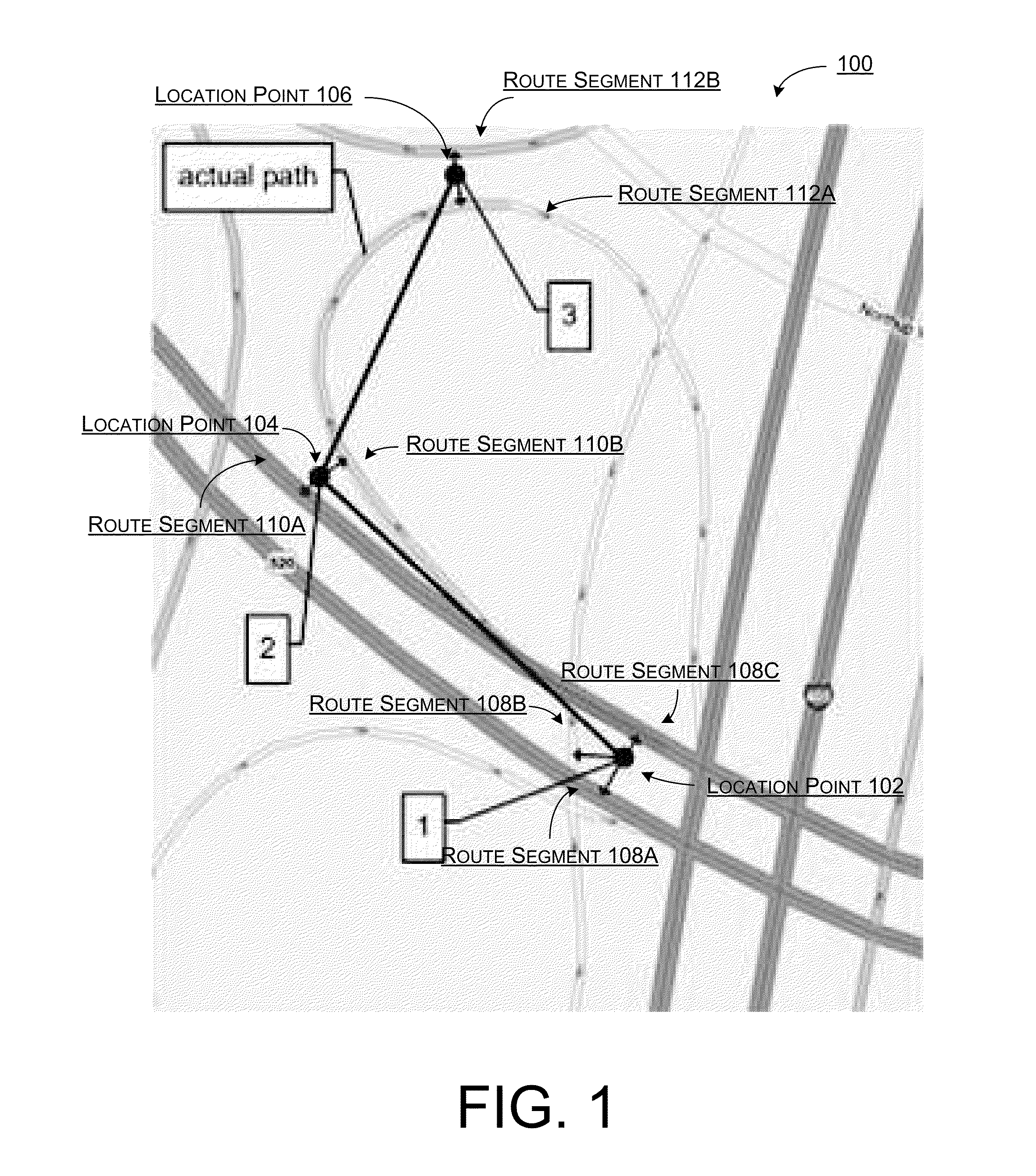
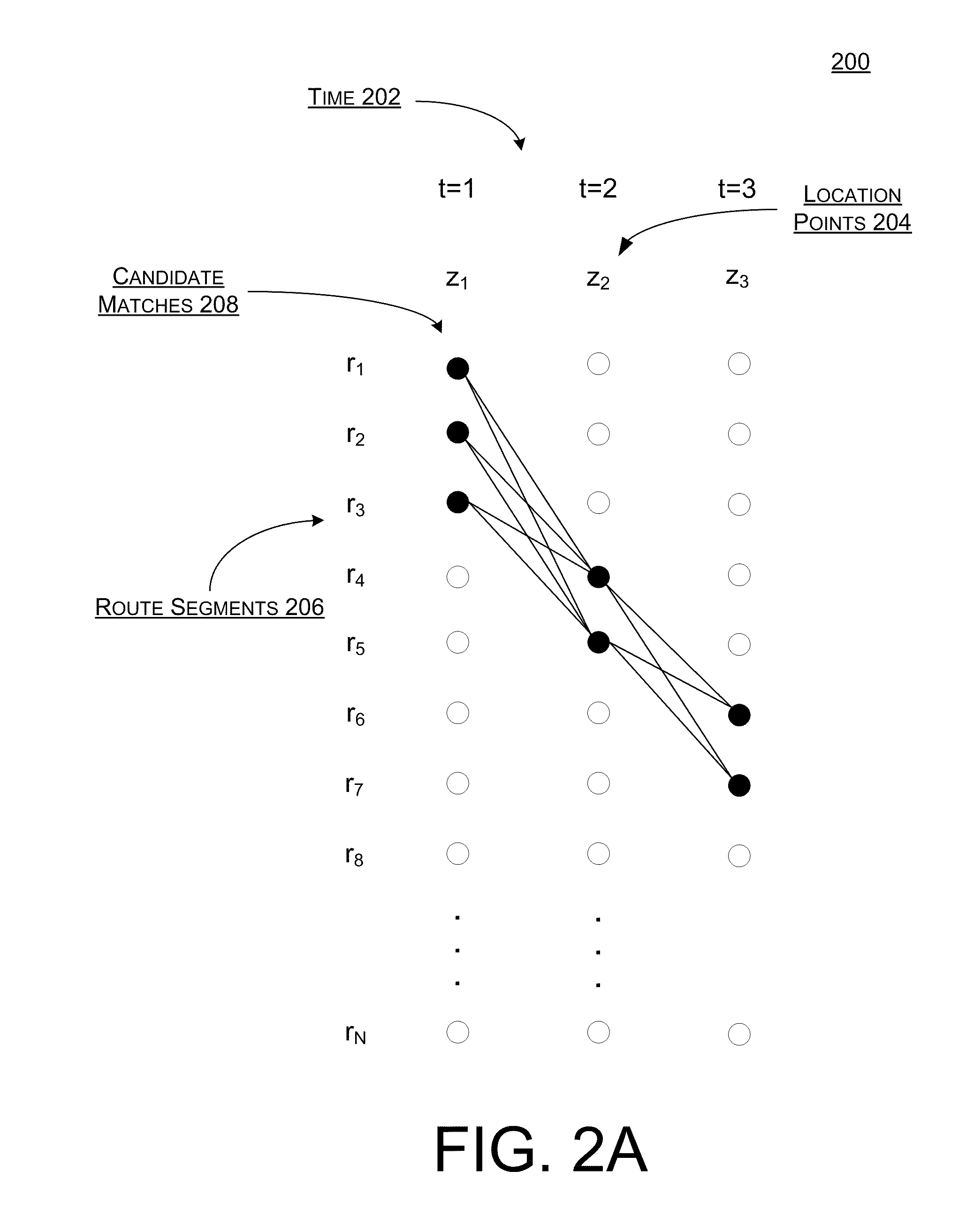
Described herein are techniques for applying map matching methods using probabilistic models, such as a Bayesian network, logistic regression, or an HMM. As stated above, map matching is often used to either identify a route being traveled based on measured location data or to determine a route previously taken using a plurality of time-adjacent location points measured over a period of time. However, as both digital maps and various sensor types, such as GPS, may display or produce inaccurate data, previous map matching methods often produced erroneous results. One problem with previous map matching methods is that they often assumed that a road or path in closest proximity to a measured location point was the route segment being traversed. However, this route segment may not be the actual road or path being traversed. For instance, location points sensed in a densely populated area of a large city may each be within a few hundred meters of a plurality of different streets. Thus, d...


PUM


Abstract

Systems, methods, and devices are described for implementing map matching techniques relating to measured location data. Probabilistic models, including temporal Bayesian network models and Hidden Markov Models, may be used for combining multiple classes of evidence relating to potential locations of points traversed on routes over time. Multiple route segments and overall routes may be maintained under relative uncertainty as candidates. The candidate route segments and overall routes may then be reduced into a smaller number of candidates or a single most likely route as a trip progresses. As the trip progresses, route segments in proximity to each location point are identified and candidate matches are determined. A probability of an entity traversing a candidate match at a given time and a probability of an entity traversing between a first candidate match at a first time and a second candidate match at a second time are determined based on a plurality of factors. Different modalities may be used to measure and transmit the location data.

Description

BACKGROUNDMap matching is a technique for determining a route based on location data received from one or more sensors. One type of location measuring mechanism, Global Positioning System (“GPS”), is widely used to determine real-time positioning of a particular person, vehicle, or any other entity capable of receiving a GPS signal. The location data received via GPS may be displayed on a digital map, which may include, for example, roads, buildings, and geographic landmarks. However, as GPS and digital maps are both prone to various errors, it is difficult to ensure that mobile positions identified via GPS are being registered properly on a digital map. As a result, an entity having a GPS sensor may be erroneously displayed on a digital map as moving through a building or moving across a body of water, or traversing an incorrect road. Although GPS data and other measured location data may not be entirely accurate, a map matching method may be useful for identifying a path or a road...

Claims


Application Information

Patent Timeline
Patent Type & Authority Applications(United States)
IPC IPC(8): G01C21/34
CPCG01C21/3484G01C21/30
Inventor NEWSON, PAUL E.KRUMM, JOHN C.HORVITZ, ERIC J.
Owner MICROSOFT TECH LICENSING LLC
Why Eureka
Try Eureka