Dynamic Scheduling for Frames Representing Views of a Geographic Information Environment

a geographic information environment and dynamic scheduling technology, applied in the field of scheduling algorithms, can solve problems such as significant visible stuttering in the application of gis

Inactive Publication Date: 2013-04-18
GOOGLE LLC
View PDF7 Cites 13 Cited by
  • Summary
  • Abstract
  • Description
  • Claims
  • Application Information

AI Technical Summary

Problems solved by technology

When displaying content, the GIS application may have a significant amount of visible stutter.

Method used


Image

  • Dynamic Scheduling for Frames Representing Views of a Geographic Information Environment
  • Dynamic Scheduling for Frames Representing Views of a Geographic Information Environment
  • Dynamic Scheduling for Frames Representing Views of a Geographic Information Environment

Examples


Embodiment Construction

[0019]I. Overview

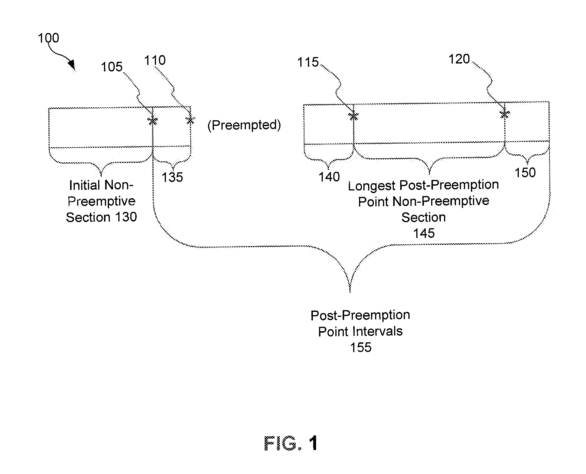
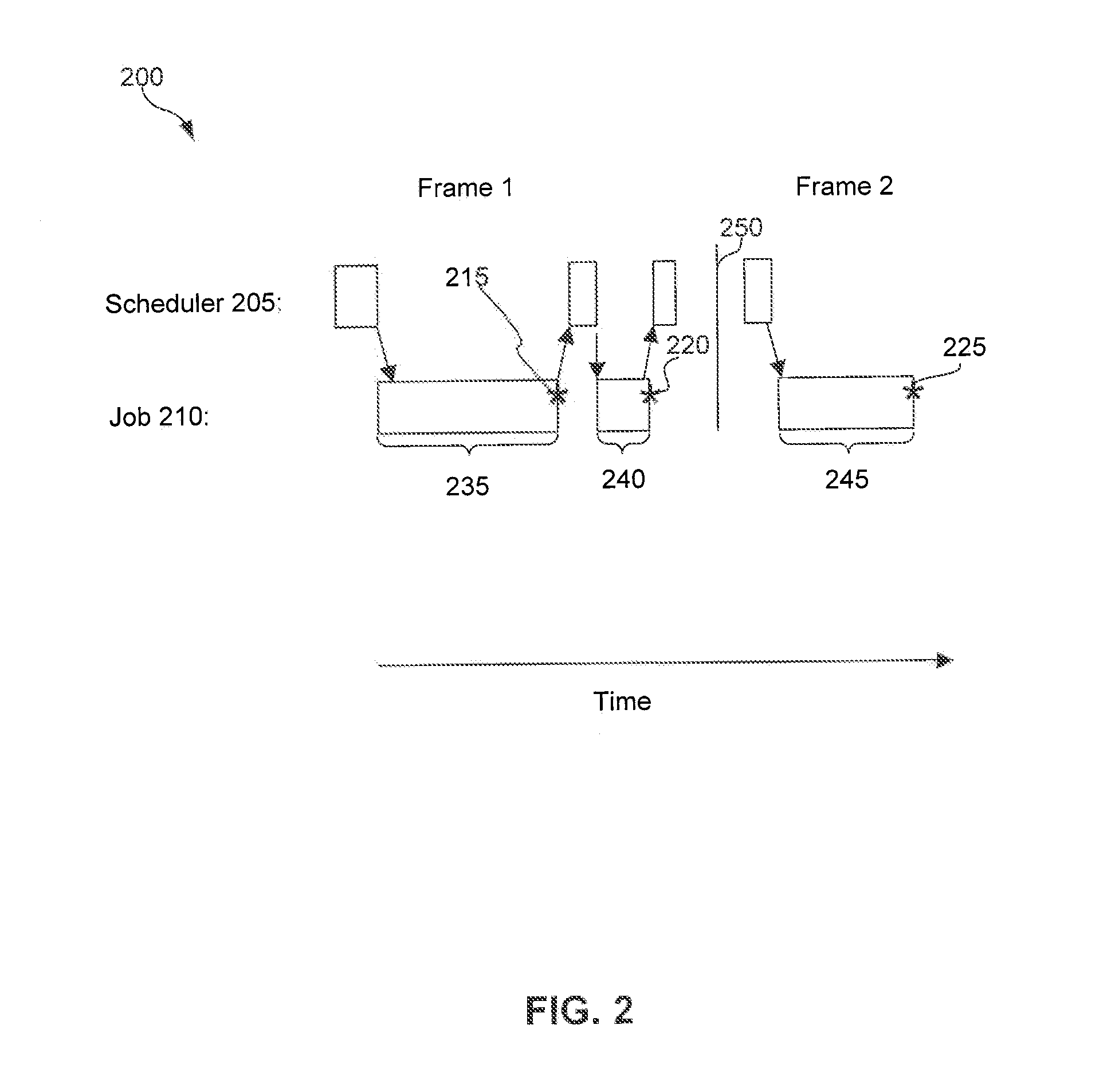
[0020]II. Jobs Executed in Frames[0021]A. Preemption Points in a Job[0022]B. Schedule Jobs[0023]C. Threads

[0024]III. Frames Representing a View in a Geographic Information Environment[0025]A. Execute Fixed Tasks[0026]B. Execute Dynamic Tasks[0027]1. Single-Active Sporadic Tasks and Soft Real-Time Aperiodic Tasks[0028]2. Update a view of a Geographic Information Environment[0029]C. Vertical Synchronization

[0030]IV. Exemplary System Architecture[0031]A. Scheduling System[0032]1. Estimated Execution Time is Not Greater Than the Remaining Frame Period[0033]2. Estimated Execution Time is Greater Than the Remaining Frame Period[0034]B. Scheduling Tasks in a Geographic Information Environment

[0035]V. Exemplary Method For Scheduling Jobs in Frames Representing Views of a Geographic Information Environment

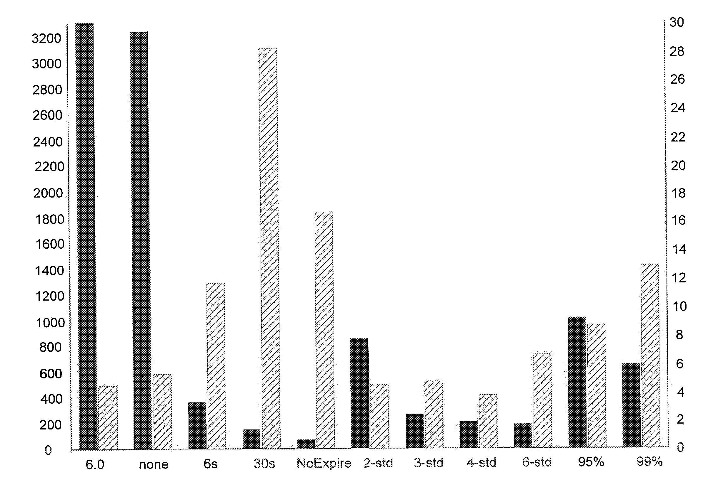
[0036]VI. Scheduling[0037]A. Scheduling Queue[0038]B. Example Scheduling Interface[0039]C. Estimate Execution Time

[0040]VII. Conclusion

I. OVERVIEW

[0041]This disclosure gene...


PUM


Abstract

An exemplary method for scheduling jobs in frames representing views of a geographic information environment is disclosed. An exemplary method includes determining a remaining frame period in a frame representing a view of a geographic information environment. The exemplary method also includes identifying a dynamic job in a scheduling queue. The dynamic job has a non-preemptive section that is between a start of the job and a preemption point of the job. The exemplary method further includes determining an estimated execution time for executing the job. When the estimated execution time is not greater than the remaining frame period, the exemplary method includes executing the non-preemptive section of the job in the frame. When the estimated execution time is greater than the remaining frame period, the exemplary method includes postponing the execution of the job in the frame.

Description

BACKGROUND[0001]1. Field[0002]This disclosure generally relates to scheduling algorithms.[0003]2. Background[0004]A geographic information system (GIS) is a system for archiving, retrieving, displaying, or manipulating data indexed according to the data elements' geographic coordinates. The data elements may be a variety of data types such as satellite imagery, maps, models of buildings and terrain, and other geographic features. The GIS may allow a user to navigate around a virtual globe and view satellite imagery, terrain, three-dimensional buildings, and geo-spatial content in a geographic information environment at a display of a device. A GIS application communicates with a server to retrieve data that is requested for display on a client device. When displaying content, the GIS application may have a significant amount of visible stutter. When a user navigates the globe, a user's experience may be more enjoyable when content is displayed quickly and smoothly.BRIEF SUMMARY[0005...

Claims


Application Information

Patent Timeline
Patent Type & Authority Applications(United States)
IPC IPC(8): G06F9/46
CPCG06F9/4887
Inventor COOMBE, GREGORY WILLIAMERICKSON, JEREMY PAUL
Owner GOOGLE LLC
Why Eureka
Try Eureka