Automatic image capture

a technology of automatic image capture and image, applied in the field of photo capture, can solve the problems of errors in geographic data collection, time-consuming initial collection of data about roads, destinations, points of interest in a geographic area,

Active Publication Date: 2014-05-15
HERE GLOBAL BV
View PDF5 Cites 41 Cited by
  • Summary
  • Abstract
  • Description
  • Claims
  • Application Information

AI Technical Summary

Benefits of technology

[0006]In one embodiment, a mobile device generates sensor data configured to describe a geographic position of a mobile device. A list of events is defined according to position data and time data. The geographic position of the mobile device is compared to positions in the list of events of interest and a current time is compared to time data in the list of events of interest. The comparison determines whether events in the list are in range of the mobile device. One or more nearby events in range of the mobile device at the current time or a future time are selected. A command is generated to capture an image of the nearby events using a camera coupled to the mobile device. The captured images may be used to update a navigation or map database, provide community or weather data to other users, social media functions, or other features.

Problems solved by technology

For example, the initial collection of data about the roads, destinations, and points of interest in a geographic area may be time consuming.
Also, geographic data used in navigation systems may become out-of-date.
There also may be errors in collected geographic data.
Updating and checking the geographic data may involve significant efforts.
Therefore, providing up-to-date and accurate geographic data is a continuing, burdensome effort.
However, the low resolution may not be capable of reliably imaging attributes that require fine detail, such as street signs.
Additionally, the illustrations are merely representational and may not be drawn to scale.

Method used


Image

  • Automatic image capture
  • Automatic image capture
  • Automatic image capture

Examples


Embodiment Construction

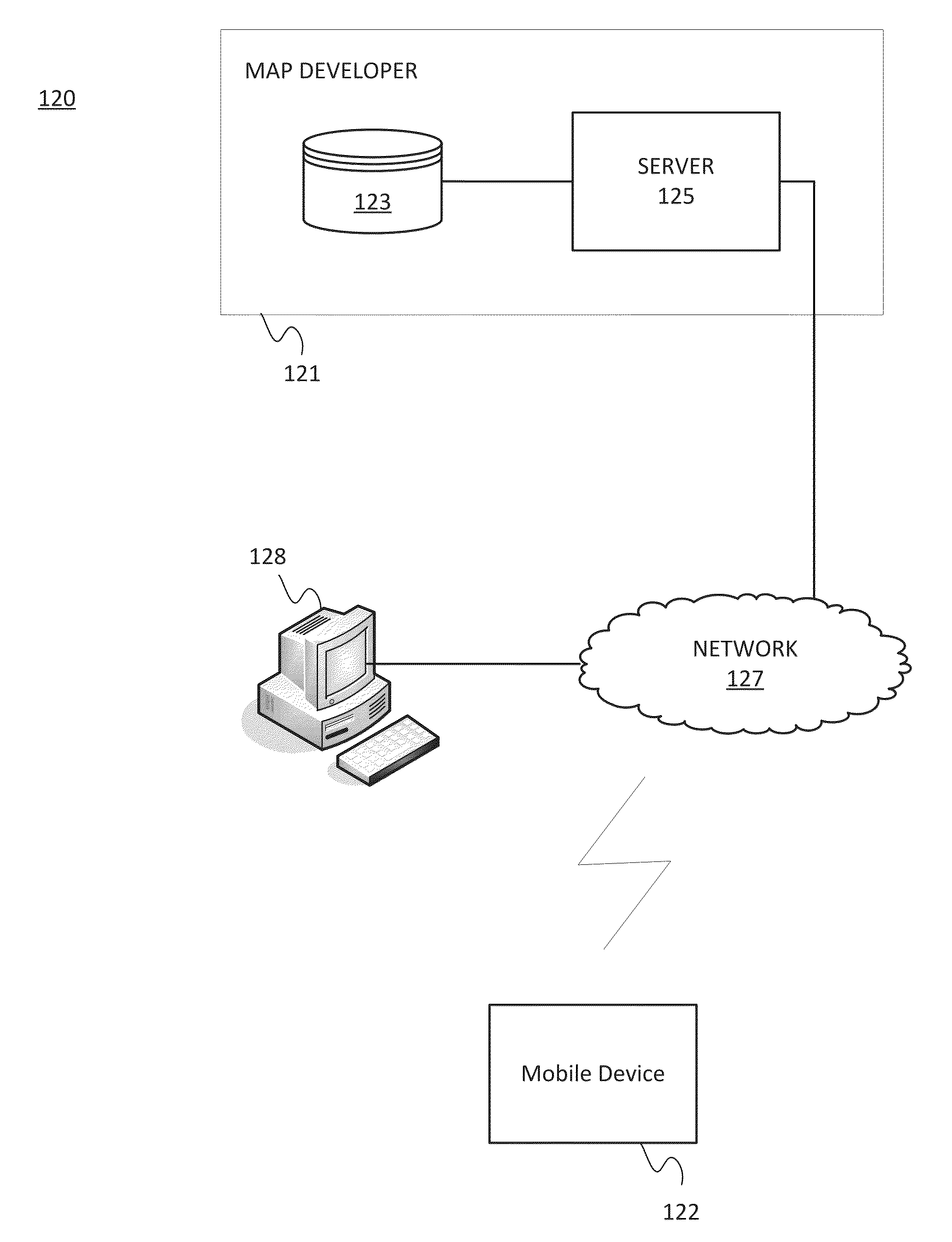
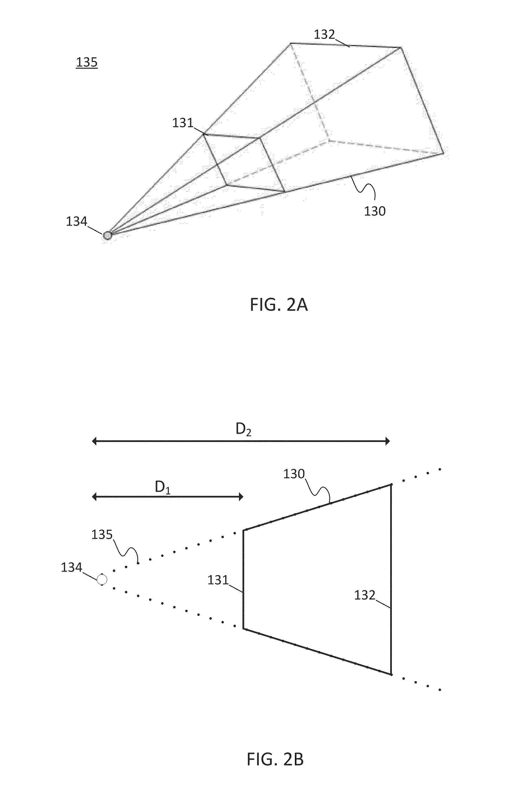
[0020]The following embodiments include an automatic photo capture for a camera in a mobile device. Rather than continuously collecting image data, images are captured only when needed. A list of events may be used to trigger the automatic photo capture. The photo capture may be triggered when a frustum or field of view of the camera in the mobile device intersects an expected location and time of an event. The collected images may be used to update a map database, provide location based features to a user of the mobile device, collect data from groups of users, or other features.

[0021]The list of events includes geographic positions and / or time ranges. This list may include a geospatio-temporal event, which includes a geographic component and a time component. The list of events may be tied to a calendar event such as an opening of a business or a concert. The list of events may include locations where a building or other point of interest has recently been removed or built. The li...


PUM


Abstract

In one embodiment, a mobile device generates sensor data configured to describe a geographic position of a mobile device. A list of events is defined according to position data and time data. The geographic position of the mobile device is compared to positions in the list of events of interest and a current time is compared to time data in the list of events of interest. The comparison determines whether events in the list are in range of the mobile device. One or more nearby events in range of the mobile device at the current time or a future time are selected. A command is generated to capture an image of the nearby events using a camera coupled to the mobile device. The captured images may be used to update navigation or map database, provide community or weather data to other users, social media functions, or other features.

Description

FIELD[0001]The following disclosure relates to photo capture in navigation-related applications.BACKGROUND[0002]Navigation systems are provided on various different computer platforms. For example, a navigation system can be a standalone system or a networked system. In a standalone navigation system, the software applications, geographic data, and hardware are combined at a single location. A standalone system may be installed in a vehicle or carried by a person. In a networked navigation system, some of the software or geographic data are located with the hardware with the user and some of the software or geographic data are located remotely and accessed over a communications system. A navigation system can be implemented on a dedicated platform in which the hardware and software are specifically designed for navigation purposes. Alternatively, a navigation system can be implemented on a general purpose computing platform (such as a personal computer, personal digital assistant, s...

Claims


Application Information

Patent Timeline
Patent Type & Authority Applications(United States)
IPC IPC(8): G01C21/00H04M1/72457
CPCG01C21/00G01C21/3647G01C21/3679G01C21/3691H04N7/185H04M2250/52H04L67/125H04W4/02H04M1/72457H04N23/661H04N23/631G01C21/3811G01C21/3837H04W4/029G01S5/0027
Inventor STROILA, MATEI NICOLAEDORUM, OLE HENRY
Owner HERE GLOBAL BV
Why Eureka
Try Eureka