Adaptive Weighting of Geophysical Data Types in Joint Inversion

Active Publication Date: 2014-05-15
LEAHY GARRETT M +5
View PDF3 Cites 8 Cited by
  • Summary
  • Abstract
  • Description
  • Claims
  • Application Information

AI Technical Summary

Benefits of technology

[0019]The present inventive method does not require any computationally expensive forward modeling steps beyond what is normally performed in gradient-based inversions, as the modified objective functi

Problems solved by technology

Obtaining models of subsurface properties is of value to extractive industries (for example, hydrocarbon production or mining) Direct sampling via drill cores can provide constraints, but direct sampling is infeasible over large areas, particularly in challenging environments.
However, inversions of remotely sensed geophysical data are typically non-unique, that is, a range of geologic models is consistent with the measured data.
In general, the inversion is non-linear and it is difficult to obtain a solution that satisfies equation (1) directly.
Unfortunately, as weight choices are arbitrary, this may direct the solver through model space in an inefficient manner, resulting in an increased number of iterations to achieve convergence.
These local minima can “trap” gradient based solvers, leading to incomplete convergence.
However, as described above, their method is prone to trapping in local minima Tonellot et al.
Unfortunately, this method does not allow the priority weights to be adjusted during the solution of the layout optimization proble

Method used


Image

  • Adaptive Weighting of Geophysical Data Types in Joint Inversion
  • Adaptive Weighting of Geophysical Data Types in Joint Inversion
  • Adaptive Weighting of Geophysical Data Types in Joint Inversion

Examples


Example

[0028]The invention will be described in connection with example embodiments. However, to the extent that the following detailed description is specific to a particular embodiment or a particular use of the invention, this is intended to be illustrative only, and is not to be construed as limiting the scope of the invention. On the contrary, it is intended to cover all alternatives, modifications and equivalents that may be included within the scope of the invention, as defined by the appended claims. Persons skilled in the technical field will readily recognize that in practical applications of the present inventive method, it must be performed on a computer, typically a suitably programmed digital computer.

DETAILED DESCRIPTION OF EXAMPLE EMBODIMENTS

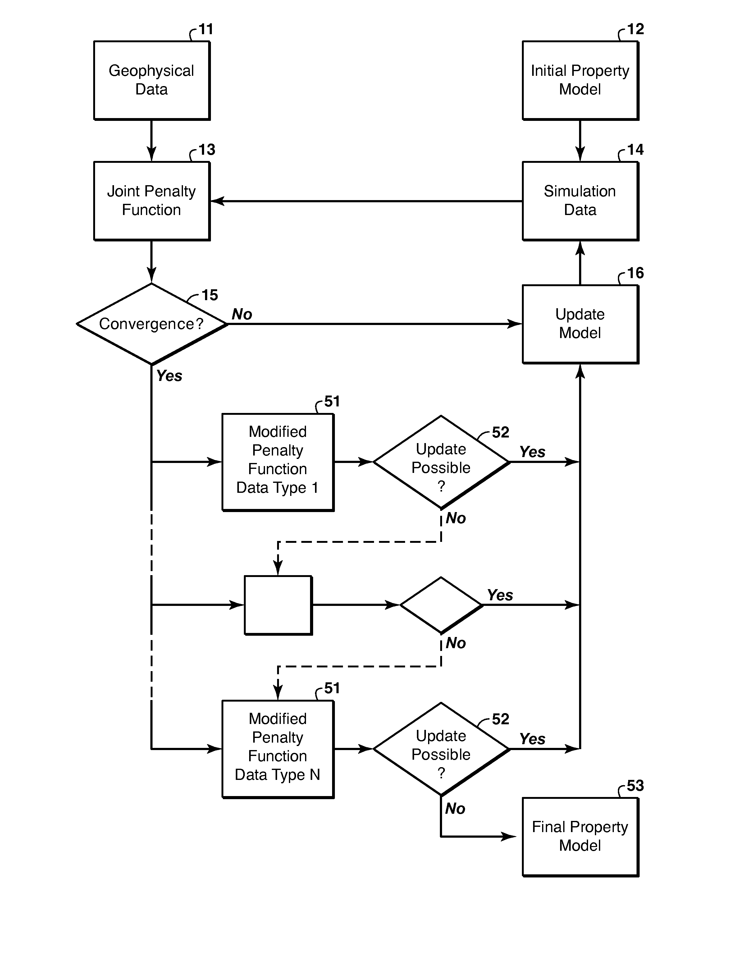
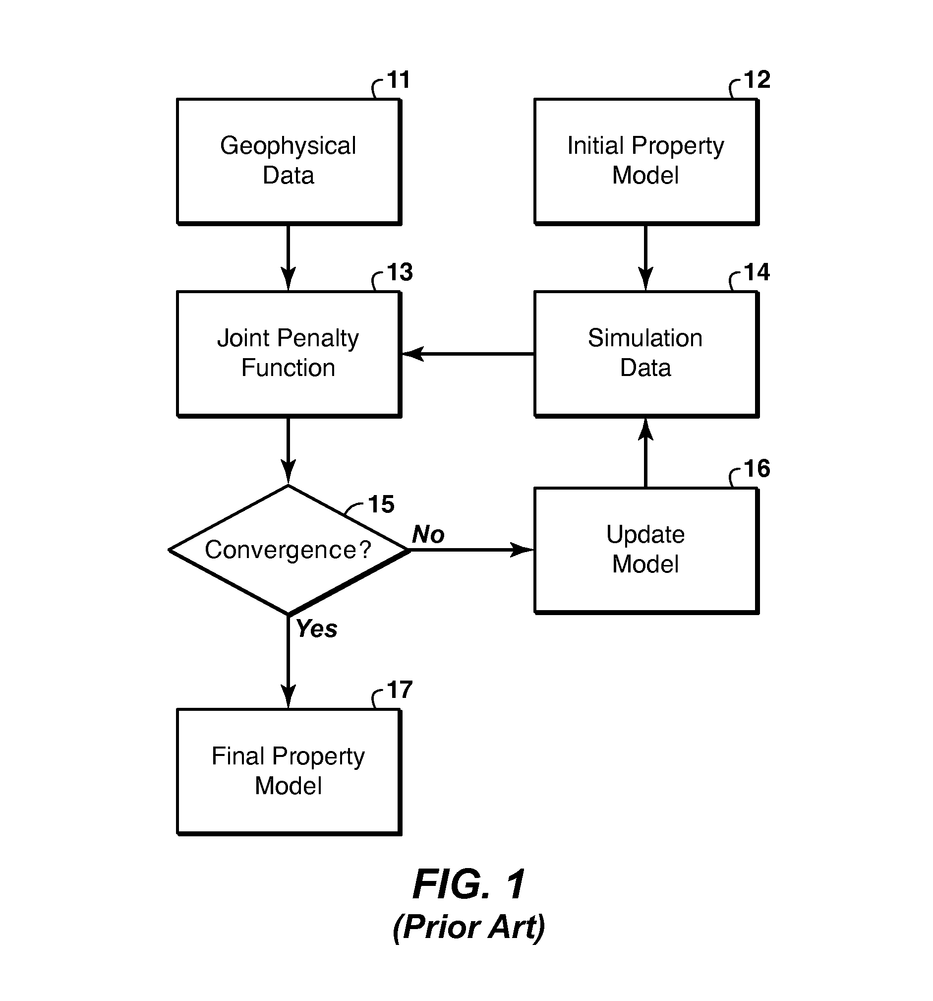
[0029]FIG. 5 provides an overview of how the present invention can be incorporated into a typical joint inversion methodology such as that outlined in the flowchart of FIG. 1. The inversion proceeds according to FIG. 1 until convergence...


PUM


Abstract

Method for adaptive weighting of geophysical data types in iterative joint inversion to speed convergence and aid escape from local minima of the penalty (objective) function. Two or more geophysical data sets (11) representing a region of interest are obtained, and are jointly inverted to infer models of the physical properties that affect the particular types of data used. The misfit for each data type is a weighted tem in the penalty function (13). The invention involves changing the weights (51) as the iteration cycles progress when the iteration convergence criteria are satisfied (15), to see if they remain satisfied (52) with the modified penalty function.

Description

CROSS-REFERENCE TO RELATED APPLICATION[0001]This application claims the benefit of U.S. Provisional Patent Application 61 / 510,363 filed Jul. 21, 2011, entitled ADAPTIVE WEIGHTING OF GEOPHYSICAL DATA TYPES IN JOINT INVERSION, the entirety of which is incorporated by reference herein.FIELD OF THE INVENTION[0002]The invention relates generally to the field of geophysical prospecting. Specifically, the invention is a method for determining a subsurface property model though joint inversion of multiple geophysical data types.BACKGROUND OF THE INVENTION[0003]Obtaining models of subsurface properties is of value to extractive industries (for example, hydrocarbon production or mining) Direct sampling via drill cores can provide constraints, but direct sampling is infeasible over large areas, particularly in challenging environments. Remote sensing via geophysical data (e.g. seismic waves, gravity, electromagnetic waves) is used instead to develop property models over large areas. However, i...

Claims


Application Information

Patent Timeline
IPC IPC(8): G01V99/00
CPCG01V99/005G01V1/30G01V3/38G01V7/00G01V11/00G01V2210/62G01V1/282G01V1/306G01V2210/612G01V2210/614G01V2210/616
Inventor LEAHY, GARRETT M.DICAPRIO, CHRISTOPHERJING, CHARLIEMULLUR, ANOOP A.SALTZER, REBECCA L.SCHMEDES, JAN
Owner LEAHY GARRETT M
Why Eureka
Try Eureka