Three-dimensional positioning method

a three-dimensional positioning and positioning method technology, applied in the field of three-dimensional positioning method, can solve the problems of not easy to form three-dimensional pairs or radar interferometry conditions, the prior art cannot meet the needs of users in the actual use, and the image cannot be used or not. to achieve the effect of improving the shortcomings

Inactive Publication Date: 2014-07-10
NAT CENT UNIV
View PDF3 Cites 39 Cited by
  • Summary
  • Abstract
  • Description
  • Claims
  • Application Information

AI Technical Summary

Benefits of technology

[0007]A main purpose of this invention is to provide a three-dimensional positioning method with the integration of radar and optical satellite images, which can effectively improve the shortcomings of the prior art. The directional information in the optical images and the distance information in the radar images are used to integrate the geometric characteristics of the optical images and the radar images in order to achieve the three-dimensional positioning.

Problems solved by technology

For the optical images, the weather disadvantageously affects whether the images can be used or not.
For the radar images, even though not affected by the weather, still has a shortage of not easy to form the three-dimensional pairs or radar interferometry conditions.
Therefore, the prior art cannot meet the need for the users in the actual use of integrating the use of the optical images and the radar images for three-dimensional positioning.

Method used


Image

  • Three-dimensional positioning method
  • Three-dimensional positioning method
  • Three-dimensional positioning method

Examples


Embodiment Construction

[0021]The aforementioned illustrations and following detailed descriptions are exemplary for the purpose of further explaining the scope of the present invention. Other objectives and advantages related to the present invention will be illustrated in the subsequent descriptions and appended tables.

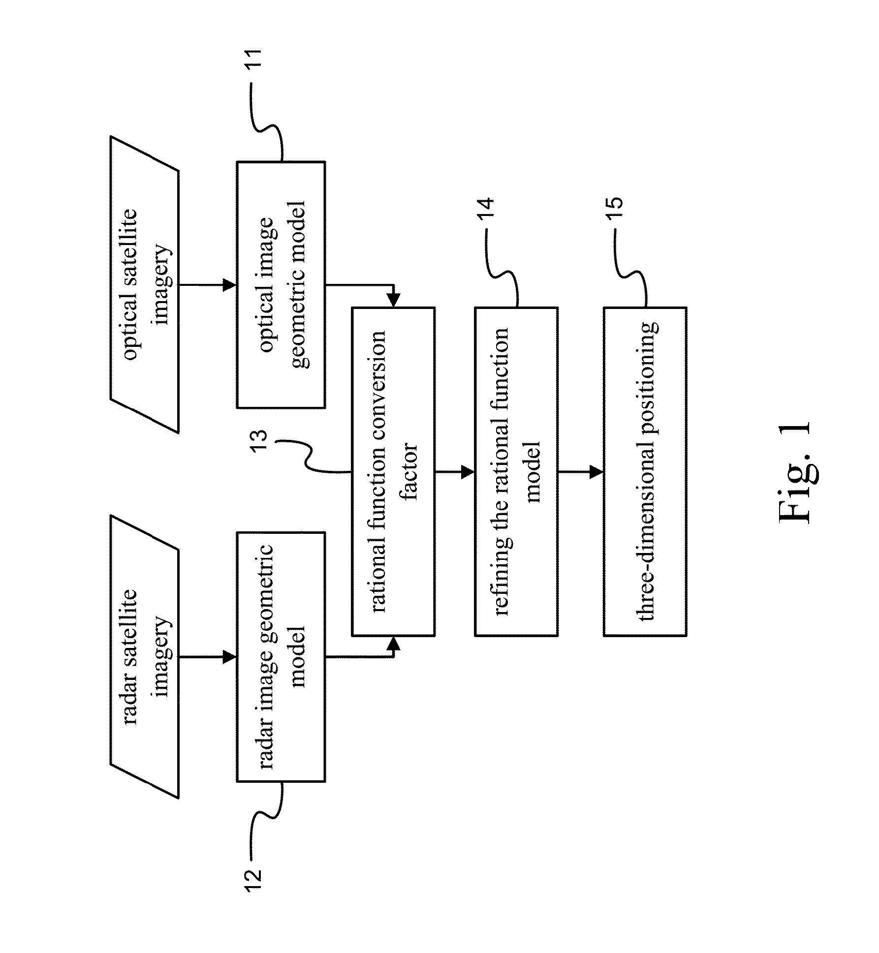
[0022]Surface three-dimensional information is essential to environmental monitoring and conservation of soil and water resources. A synthetic aperture radar (SAR) and optical imaging offer the main telemetry data for obtaining the three-dimensional information. The integration of the information from both the optical and radar sensors can get more useful information. Please refer to FIG. 1 which is a schematic view of flow chart of three-dimensional positioning by means of the integration of radar and optical satellite imagery according to the present invention. As shown, the present invention relates to a method for three-dimensional positioning by means of the integration of radar and o...


PUM


Abstract

A three-dimensional positioning method includes establishing the geometric model of optical and radar sensors, obtaining rational function conversion coefficient, refining the rational function model and positioning the three-dimensional coordinates. Most of the radar satellite companies and part of the optical satellite only provide satellite ephemeris data, rather than the rational function model. Therefore, it is necessary to obtain the rational polynomial coefficients from the geometric model of optical and radar sensors; followed by refining the rational function model by the ground control points, so that object image space intersection is more serious; and then followed by measuring the conjugate point on the optical and radar images. Finally, the observation equation is established by the rational function model to solve the three-dimensional coordinates. It is obvious from the above results that the integration of optical and radar images does achieve the three-dimensional positioning.

Description

BACKGROUND OF THE INVENTION[0001]1. Field of the Invention[0002]The present invention relates to a three-dimensional positioning method, particularly to a three-dimensional positioning method which can be applied to various satellite images in a satellite positioning system. More particularly, it relates to a three-dimension positioning method which uses a rational function model (RFM) with the integration of optical data and radar data.[0003]2. Description of Related Art[0004]Common information sources for surface stereo information by satellite images can be acquired by using optical images and radar images. For optical satellite images, the most common method is to use three-dimensional image pairs. For example, Gugan et al have proposed their researches about accurate and integrity for topographic mapping based on SPOT imagery (Gugan, DJ and Dowman, I J, 1988. Accuracy and completeness of topographic mapping from SPOT imagery Photogrammetric Record, 12 (72), 787-796). One pair o...

Claims


Application Information

Patent Timeline
Patent Type & Authority Applications(United States)
IPC IPC(8): G01S13/86
CPCG01S13/86G01S13/867G06T2207/10036G06T2207/10044G01C21/005G06T7/55G01S13/9027B64G1/1035B64G1/1028
Inventor CHEN, LIANG-CHIENYANG, CHIN-JUNG
Owner NAT CENT UNIV
Why Eureka
Try Eureka