Positioning system

a positioning system and positioning system technology, applied in the field of positioning systems, can solve the problems of large amount of data being sent to the location server, inability to easily extend data into regions, and inability to use existing systems, etc., to facilitate the estimation of the position of sources

Active Publication Date: 2014-12-11
HUAWEI TECH CO LTD
View PDF1 Cites 41 Cited by
  • Summary
  • Abstract
  • Description
  • Claims
  • Application Information

AI Technical Summary

Benefits of technology

[0023]By associating signal sources with geographical regions, and then selectively processing signal data relating to certain of those regions, the processing of the signal data can be prioritised in a relatively computationally efficient manner, allowing more important signal source data associated with specific geographical regions to be processed in a timely fashion, substantially regardless of increasing volumes of signal data being received from users. Preferably, the database of electromagnetic signal source data is also updated in dependence on computed position estimates concerning some or all of the plurality of electromagnetic signal sources which are not selected, but less quickly (i.e. so that there is on average a greater delay) or less comprehensively (e.g. so that some of the signal data for the unselected signal sources is not used to update the database).
[0135]Preferably this exemplary method further comprises processing the signal source position data and the further signal source position data to determine an appropriate adjustment to the signal source position data. Any appropriate process may be used to determine the appropriate adjustment, including least squares estimation methods, for example. The method may also further comprise processing the signal detection data to estimate the location of additional signal sources that were not detected at the first plurality of locations, and adding additional signal source position data to the signal source position data. Thus the second phase of scanning (at the second set of locations) may for example uncover signal sources (such as WAP base stations) that were not found in the first phase of scanning (at the first set of locations). The scanning at the first plurality of locations preferably comprises: scanning at the first plurality of locations to generate initial signal detection data, the initial signal detection data relating to signals received at the first plurality of locations from the signal sources; processing the initial signal detection data in dependence on first scanning position data, the first scanning position data representing the position of each of the first plurality of locations, in order to generate the position estimate data. Accordingly the signal sources can be used in both phases to facilitate the estimation of the position of the sources.

Problems solved by technology

However, they cannot be readily used to extend data into regions where existing master databases have significant gaps (referred to herein as void zones).
This means that users of existing systems may find themselves unable to use a given positioning system despite the presence of temporarily or permanently stationary electromagnetic sources which could be detected by their mobile device.
Indeed, there is a further incentive to widen user participation to improve the accuracy of estimates, but the pressure to include data from more users and to provide more detailed information results in a vast amount of data being sent to the location server.
However, no teaching is provided of how to cope with the vast amount of data which may be gathered from a plurality of user devices in such a situation.
However, the method of US2011 / 0026506 involves discarding collected information which is not being actively sought by the server before it is provided to the server which leads to the loss of potentially useful information.
This means that there is typically a lengthy delay between the detection of an electromagnetic signal source which was previously unknown and the availability of its position for use in estimation of the position of a user device.
However, data from a plurality of user devices is processed in a batch before the refined estimate of the position of a satellite can be used in the estimation of a position of a mobile device, leading to a significant delay before the refined estimate of the position of the satellite can be used in estimating the position of a mobile device.

Method used


Image

  • Positioning system
  • Positioning system
  • Positioning system

Examples


Embodiment Construction

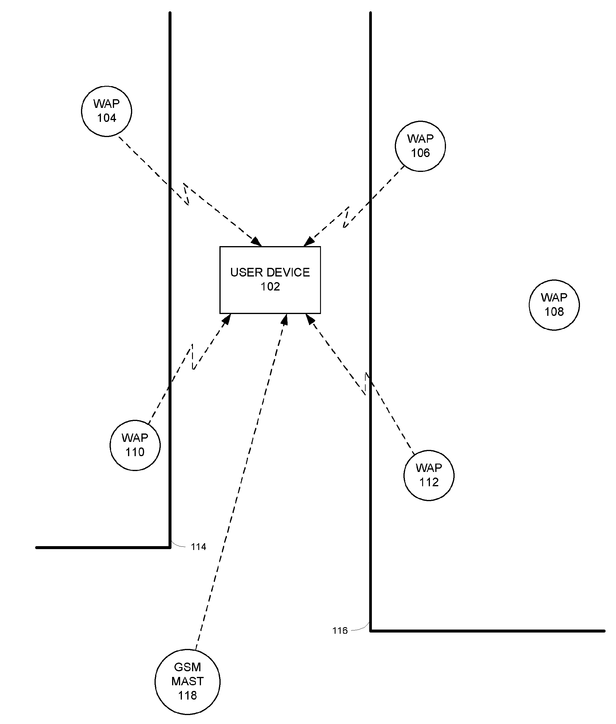
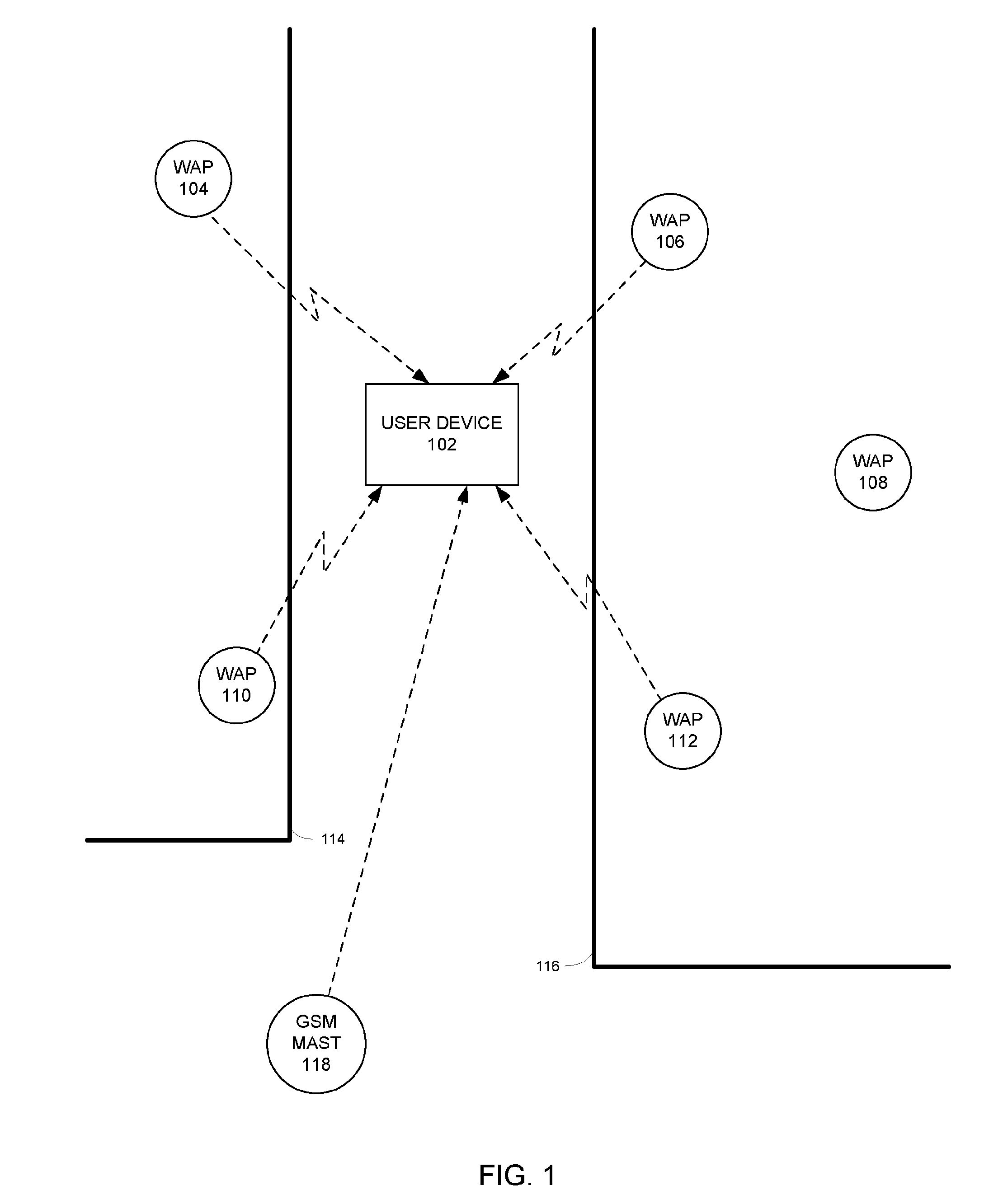
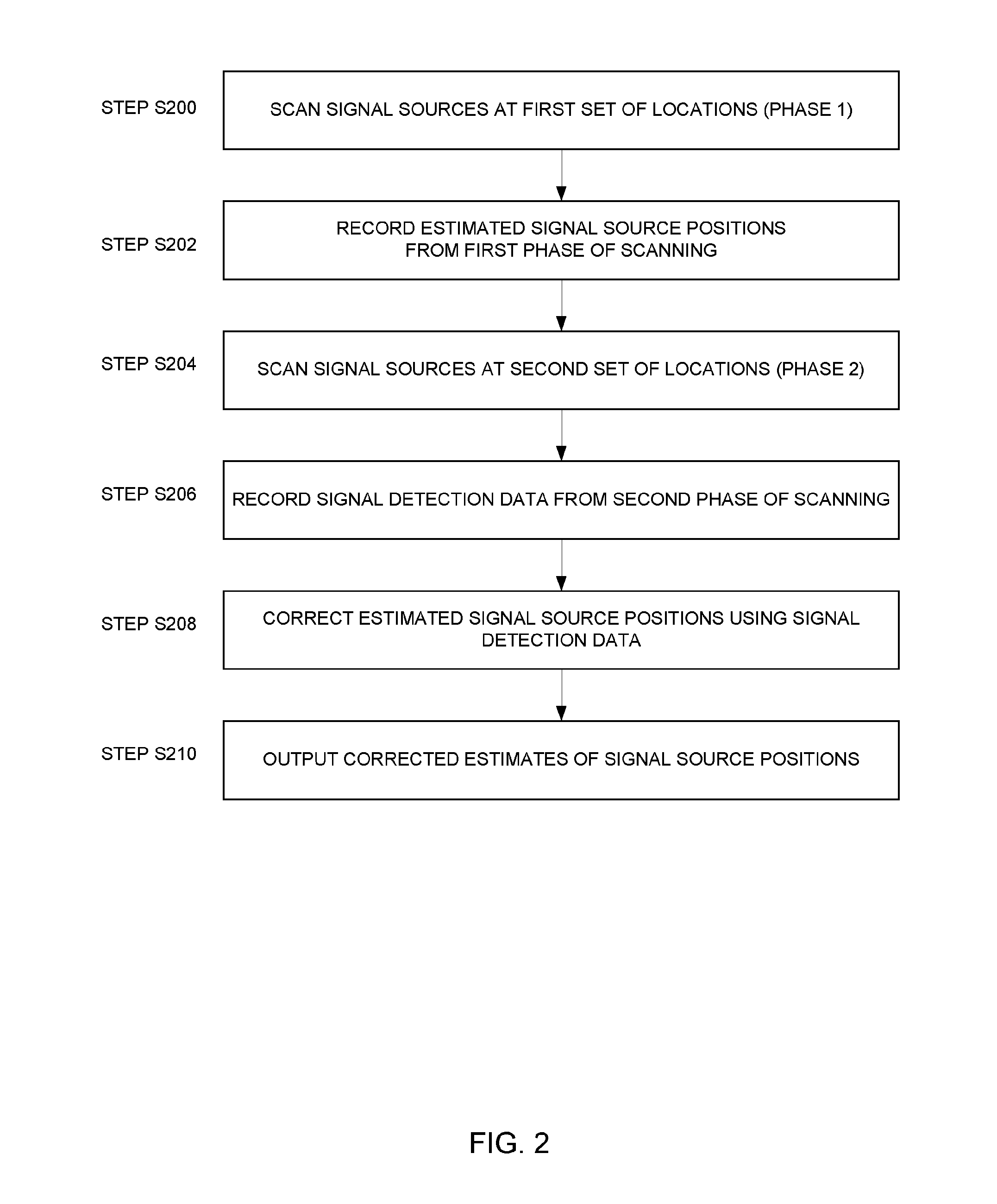
[0166]A method and system will be described for locating electromagnetic signal sources, with a particular (but not exclusive) application to a system for locating a user device by cross-referencing signals received at the user device with data previously gathered using the abovementioned method and system. Thus, the location of stationary electromagnetic signal sources is estimated. Errors in the estimates of the location of the stationary electromagnetic signal sources are corrected. The resulting locations of the stationary electromagnetic signal sources are later used as reference points for locating a (typically mobile) user device.

[0167]In one particular embodiment a method is described in relation to dynamically determining the location (such as position co-ordinates) of Wireless Access Points (WAPs) or Wireless Beacons in wireless technology-based positioning systems. Predominantly the wireless standard described in this document is Wi-Fi and the positioning system is a Wi-F...


PUM


Abstract

There is disclosed a method of managing a database of positioning data, the positioning data including electromagnetic signal source data for use by a positioning system, and the method comprising: receiving signal data relating to signals received from a plurality of electromagnetic signal sources; associating an appropriate one of a plurality of zone identifiers with each of the electromagnetic signal sources, each zone identifier being associated with a respective geographical zone; selecting a subset of the plurality of electromagnetic signal sources in dependence on their associated zone identifiers; processing the signal data relating to the subset of the plurality of electromagnetic signal sources to compute position estimates of the electromagnetic signal sources; and updating the database of electromagnetic signal source data in dependence on the computed position estimates.

Description

FIELD OF THE INVENTION[0001]The present invention relates to a method of and system for identifying the position of a user using emissions from a plurality of electromagnetic signal sources, and to a method of managing a database concerning electromagnetic signal sources for use as part of such a method and system.BACKGROUND TO THE INVENTION[0002]One example of an electromagnetic signal source is a wireless access point, such as a Wi-Fi base station (Wireless Access Point), which is used to communicate wirelessly with a device by the transmission and reception of electromagnetic radiation in the form of radio waves. Other electromagnetic signal sources may for example include optical (infra-red) communication devices and electromagnetic / wireless beacons of various sorts, including connectable and non-connectable beacons according to the Bluetooth short range wireless connectivity standard specification (Bluetooth beacons).[0003]It is known to use electromagnetic signal sources, such...

Claims


Application Information

Patent Timeline
Patent Type & Authority Applications(United States)
IPC IPC(8): G06F17/30H04W64/00
CPCH04W64/00G06F17/30241G01S5/0242G06F16/29G06F16/27G06F16/275G01S5/0249
Inventor ARSLAN, TUGHRUL SATISEVAK, ZANKAR UPENDRAKUMARALSEHLY, FIRAS
Owner HUAWEI TECH CO LTD
Why Eureka
Try Eureka