
System and method for automatic geometric correction using rpc

a technology of automatic geometric correction and rpc, which is applied in the field of automatic geometric correction using rpc, can solve the problems of inability to determine the accurate location from images, the inability to use images to determine the exact location, and the general inaccurateness of observation posture and observation angle given as auxiliary data, so as to reduce the cost and time, increase the accuracy of extraction ground coordinates, and simplify the generation process

Active Publication Date: 2015-02-12
UNIV OF SEOUL IND COOP FOUND
View PDF1 Cites 17 Cited by
  • Summary
  • Abstract
  • Description
  • Claims
  • Application Information

AI Technical Summary

Benefits of technology

The present invention solves the technical problem of accurately correcting the geometry of images using RPCs (rational polynomial coefficients) only when a few or more ground control points are given. This requires fewer physical and human resources for the acquisition of ground control points and allows for accurate 3D location information to be acquired even for inaccessible areas. The invention provides technology to automatically extract ground control points using a digital elevation model, reducing costs and time for image geometrical correction and improving accuracy. A system for automatic geometric correction using RPCs is described, which simplifies the processes of generating an orthoimage, image map, digital map, and digital elevation model, and reduces task time.

Problems solved by technology

In the case of linear scanning images, an observation location and speed, an observation posture and an observation angle given as auxiliary data are generally inaccurate.
Accordingly, when the geometry of the linear scanning images is recovered using the auxiliary data, geometric distortion occurs, with the result that accurate locations cannot be determined from the images.
In particular, in the case of satellite images, the situation is more serious.
However, because of a constraint condition requiring a visit to an actual place, considerable time and cost are required, and actual measurement itself cannot be performed in an inaccessible place, such as North Korea.
However, the use of a small number of ground control points is problematic in that an error in the selection of image points in images and distortion attributable to the location error of ground points may occur and also the above method cannot be used in an area in which ground control points cannot be obtained.
Meanwhile, research that has been conducted so far is disadvantageous in that data clips requiring high costs in an early stage, such as geometrically corrected satellite images, Synthetic Aperture Radar (SAR) images, Light Detection And Ranging (LIDAR) data, a Ground Control Point (GCP) chip, a digital map, etc., are prerequisites, manual work is partially required to make the coordinate systems of images uniform when multi-sensor data, such as SAR images, is used, and a processing process is relatively very complicated.
Furthermore, the accuracy of performed final geometric correction is also unsatisfactory.

Method used


Image

  • System and method for automatic geometric correction using rpc
  • System and method for automatic geometric correction using rpc
  • System and method for automatic geometric correction using rpc

Examples


Embodiment Construction

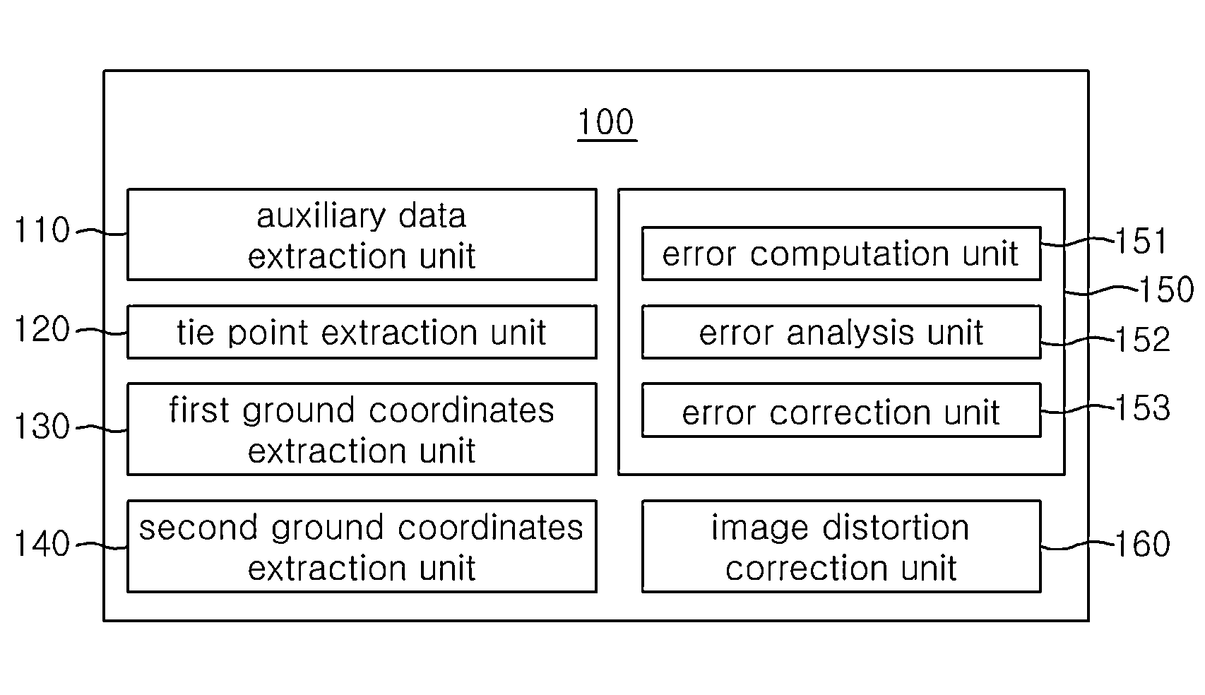
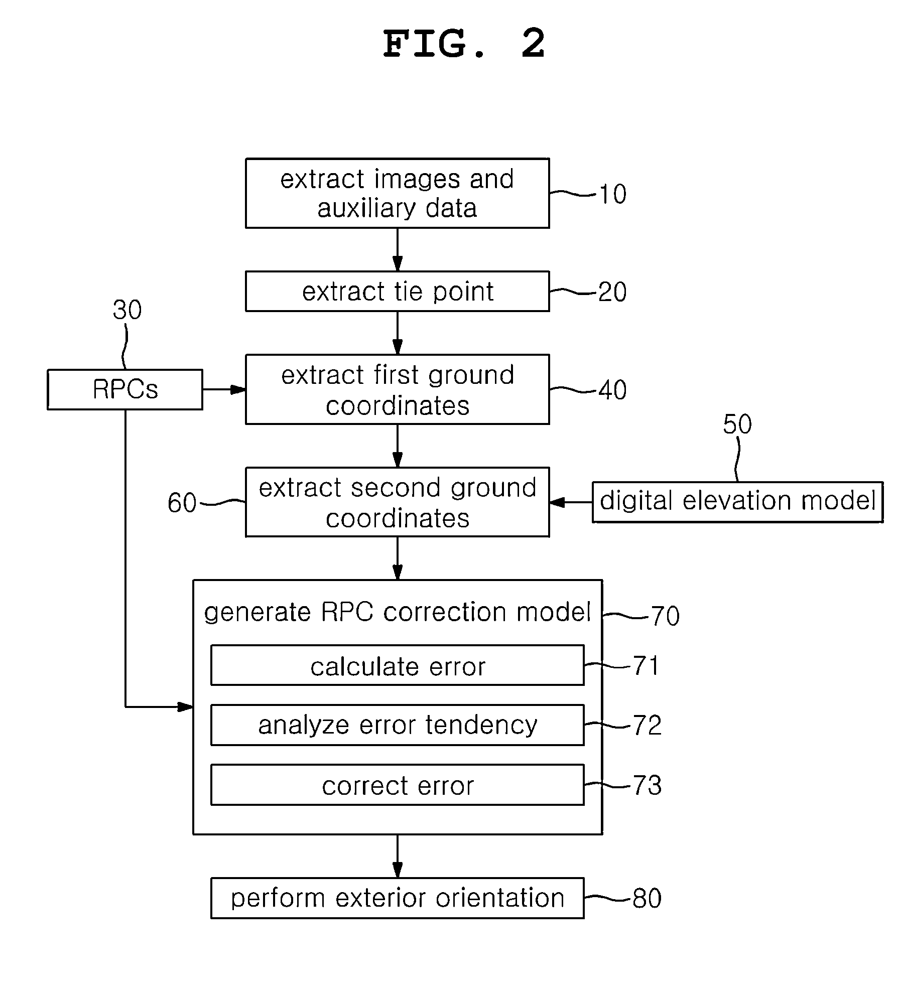
[0023]In order to achieve the above objects, a system for automatic geometric correction using RPCs in accordance with the present invention includes an auxiliary data extraction unit, a tie point extraction unit, a first ground coordinates extraction unit, a second ground coordinates extraction unit, an RPC correction model generation unit, and an image distortion correction unit. The auxiliary data extraction unit extracts two or more different images, acquired by photographing a same ground surface, and auxiliary data on the images. The tie point extraction unit extracts a tie point from the two or more different images through image matching. The first ground coordinates extraction unit extracts first ground coordinates from the tie point and the RPC (rational polynomial coefficient) model of the auxiliary data. The second ground coordinates extraction unit extracts second ground coordinates using the first ground coordinates and the correlation coefficients of a digital elevati...


PUM


Abstract

The present invention relates to a technique for correcting a geometric image error calculated as a rational polynomial coefficient (RPC) only through a corresponding point extracted from a digital elevation model (DEM) and a stereoscopic image without direct measurement of a ground control point (GCP). To this end, a system for automatic geometric correction using an RPC in accordance with the present invention comprises: an auxiliary data extraction unit; a corresponding point extraction unit; a first ground coordinate extraction unit; a second ground coordinate extraction unit; an RPC correction model generation unit; and an image distortion correction unit. The auxiliary data extraction unit extracts two or more different images captured from the same ground surface and auxiliary data of the two or more different images. The corresponding point extraction unit extracts a corresponding point from the two or more different images through image matching. The first ground coordinate extraction unit extracts first ground coordinates from the corresponding point and an RPC model of the auxiliary data. The second ground coordinate extraction unit extracts second ground coordinates by using the first ground coordinates and a correlation coefficient of a DEM. The RPC correction model generation unit generates an RPC correction model by correcting the RPC model on the basis of the second ground coordinates. The image distortion correction unit corrects distortion of an image by allocating ground coordinates to each image coordinates of the image by using the second ground coordinates and the RPC correction model.

Description

CROSS-REFERENCE TO RELATED APPLICATION[0001]This is a continuation of International Application No. PCT / KR2013 / 003267 filed on Apr. 18, 2013, which claims priority to Korean Application No. 10-2012-0043031 filed on Apr. 25, 2012. The applications are incorporated herein by reference.TECHNICAL FIELD[0002]The present invention relates, in general, to a system and method for automatic geometric correction using RPCs and, more particularly, to technology for correcting an RPC model determined from the statues of satellites, locations and camera information, when satellite images were photographed, using ground control points automatically extracted from a digital elevation model, thereby allocating accurate ground coordinates to each set of image coordinates of the images.[0003]The present invention was contrived based on research that was conducted as part of the General Researcher Support Project sponsored by the Korean Ministry of Education, Science and Technology and the National Re...

Claims


Application Information

Patent Timeline
IPC IPC(8): G06T17/05G06K9/46G06K9/62G06T5/00G06V20/13
CPCG06T17/05G06T5/006G06K9/6201G06K9/4604G06T5/002H04N13/106G06V20/13G06T3/153G06T5/80G06T7/60H04N5/21G06F18/22G06T5/70
Inventor JUNG, HYUNG SUPOH, KWAN YOUNG
Owner UNIV OF SEOUL IND COOP FOUND
Learn More