Improvements in relation to underwater imaging for underwater surveys

a technology for underwater surveys and underwater imaging, applied in the field of underwater imaging for underwater surveys, can solve the problems of reducing the resolution of the captured image, reducing the time required for review of the survey, and affecting the accuracy of underwater surveys

Active Publication Date: 2016-07-07
CATHX RES
View PDF5 Cites 23 Cited by
  • Summary
  • Abstract
  • Description
  • Claims
  • Application Information

AI Technical Summary

Benefits of technology

[0026]In this way a very useful augmented output image may be generated automatically. This greatly reduces the time required to review a survey.

Problems solved by technology

Considerable costs are incurred in surveying and inspection of artificial structures such as ship hulls; oil and cable pipelines; and oil rigs including associated submerged platforms and risers.
However, it is important to note that Bayer filters reduce the resolution of the captured image, while 3-chip CCD cameras are bulky.
There are a number of specific environmental issues with underwater imaging that have an impact on image quality, for example as mentioned, colour absorption in water.
Accordingly, during one frame or image acquisition period it is possible for there to have been relative motion of 20 mm, which can result in blurring, which in turn may have an impact on image quality under certain conditions of object field size, sensor size and magnification.
Particles and backscattered light form floating or moving particles in the field of view are another example of image quality issues in underwater imaging caused by environmental conditions, one that can have a significant impact on the images acquired.
While conventional image and video compression techniques, such as those used to generate MPEG4 files, are routinely used to reduce the storage and transmission overhead so as to allow about one hour of standard HD video be stored in 2 GB, these techniques may not always be suitable for compressing survey data.
Other camera sensors exist that have even higher resolutions and these may be used in some proprietary systems, resulting in even larger volumes of data produced and requiring suitable storage
It is clear that extensive surveying, at high resolutions, will obviously produce extremely large volumes of data.
The storage and transmission of such volumes presents a significant cost to the surveying industry, especially in terms of bandwidth required to transmit the data from offshore locations over satellite communications.
In addition to these costs are the labour overheads of the analysis of hours of video data by a human observer who must generally view the video survey in real time.
However, many survey vehicles have optical systems with fixed focus arrangements and / or extensive depths of field which restrict the accuracy that can be reliably achieved when operating over large distances.
Its range underwater is limited to tens of metres due to the high absorption of light in water.
These scaling and ranging techniques all require specialised and complicated technology.
They are expensive to develop, generally bulky and difficult to maintain.

Method used


Image

  • Improvements in relation to underwater imaging for underwater surveys
  • Improvements in relation to underwater imaging for underwater surveys
  • Improvements in relation to underwater imaging for underwater surveys

Examples


examples

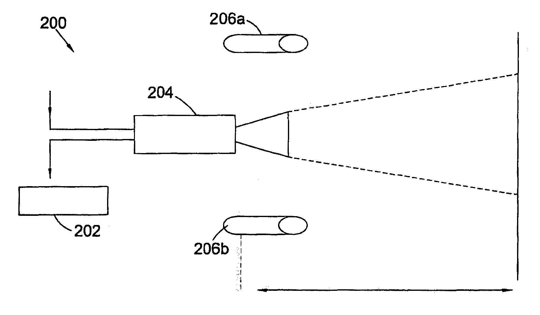
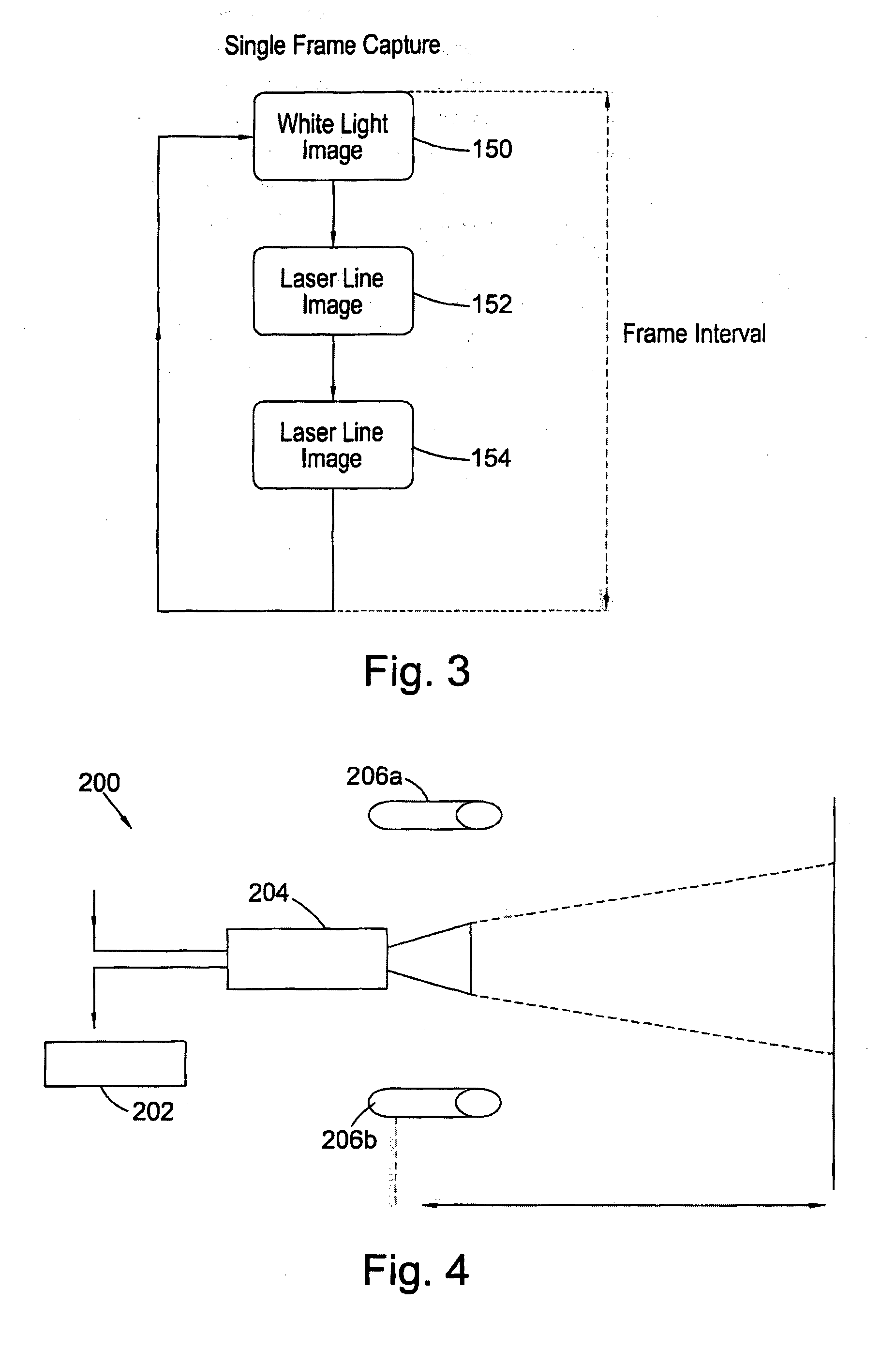
[0208]One of the simplest embodiments of the present invention is to capture a white light image of a scene and a pair of laser lines image of that same scene. The laser lines image can be used to provide range and dimension information for the white light image, such as the distance to objects in the image and sizes of those objects. This information can be overlaid on the white light image, or otherwise included as metadata with the image to form the augmented output image. It is also possible to carry out edge detection on the white light image, and highlight any edges found in the white light image. In this example, the whole white light image is included in the augmented output image, the range and dimensioning are aspects derived from the laser lines image, and any highlighted edges or info derived therefrom are aspects derived from the white light image. Certain information would be derived from a combination of the white light image and the laser lines image, for example the...


PUM


Abstract

The present invention relates to methods and systems for performing underwater surveys, in particular on sub-sea installations such as oil and gas pipelines, risers, well-heads and so on. Further the invention relates to providing an augmented underwater image of a scene for use in an under-water survey, using an underwater imaging system comprising a light module, image processing module and a camera module, the light module comprising a plurality of light classes each light class having one or more light sources. The invention uses sequential imaging to provide the augmented output image.

Description

[0001]The present invention relates to a system and method for underwater imaging, in particular in relation to carrying out underwater surveys. The present invention relates to an underwater imaging system comprising a light module and a camera module, and methods for operation of the system.BACKGROUND[0002]Underwater surveying and inspection is a significant component of many marine and oceanographic sciences and industries. Considerable costs are incurred in surveying and inspection of artificial structures such as ship hulls; oil and cable pipelines; and oil rigs including associated submerged platforms and risers. There is great demand to improve the efficiency and effectiveness and reduce the costs of these surveys. The growing development of deep sea oil drilling platforms and the necessity to inspect and maintain them is likely to push the demand for inspection services even further. Optical inspection, either by human observation or human analysis of video or photographic d...

Claims


Application Information

Patent Timeline
Patent Type & Authority Applications(United States)
IPC IPC(8): H04N5/225B60R1/00G06K9/46G06F17/30H04N7/18H04N5/265
CPCH04N5/2256H04N7/18B60R1/00G06K9/46G06F17/30265H04N5/265G06T1/0007G06T11/00G06T2200/32G06T2207/10144G06T2207/10152G06F16/58G06F16/5866G06T3/4038G01C11/02Y02A90/30H04N23/56H04N23/90G06F16/587G01C3/08
Inventor BOYLE, ADRIANFLYNN, MICHAEL
Owner CATHX RES
Why Eureka
Try Eureka