
Precision guidance method and system for aircraft approaching and landing

a technology of aircraft approaching and landing, applied in the direction of automatic aircraft landing aids, aircraft traffic control, instruments, etc., can solve the problems of not being able to achieve vfr, the blades of windmills are particularly dangerous obstacles, and the oil & gas platforms are brightly lit and frequently disturbed

Inactive Publication Date: 2016-11-24
TEIA
View PDF7 Cites 7 Cited by
  • Summary
  • Abstract
  • Description
  • Claims
  • Application Information

AI Technical Summary

Benefits of technology

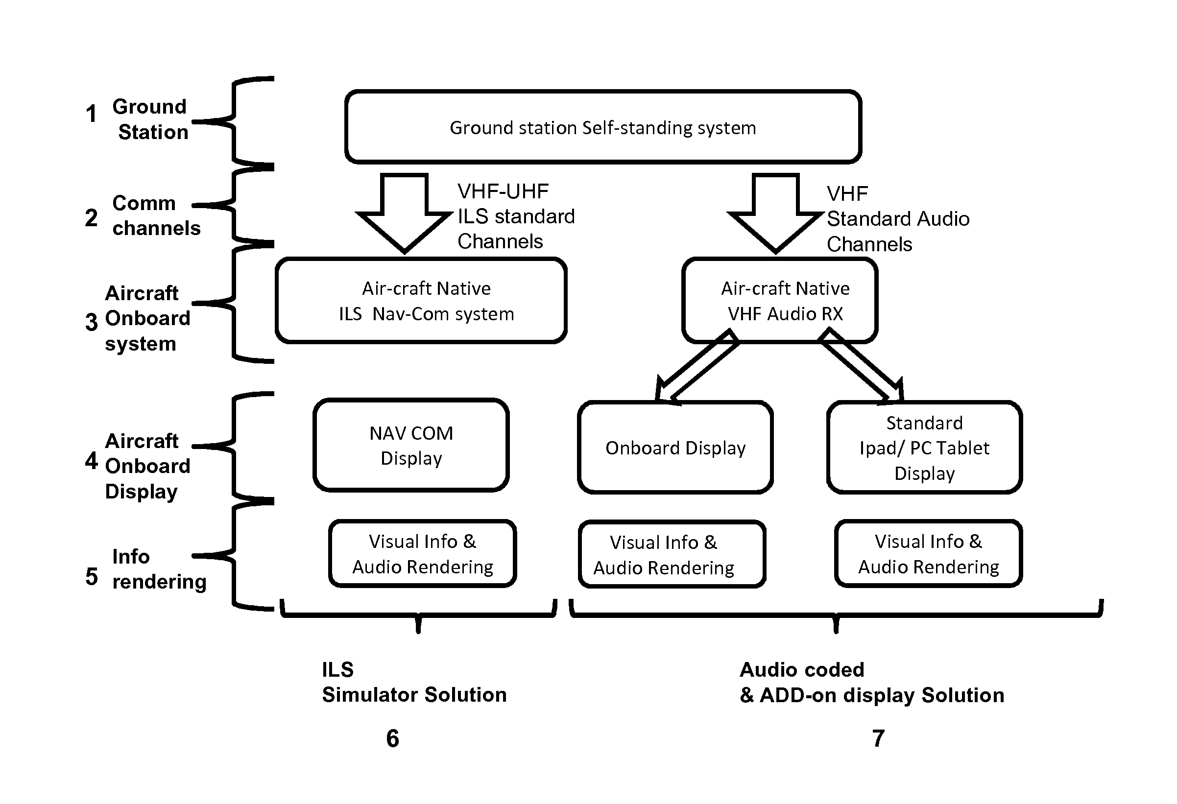
The present invention is a method and system for aircraft approach and landing that is simple to install, uses maximum degree technologies, and is economical and safe. It provides guidance to pilots during both the approach and landing phases, improving the visual approach currently used. The invention achieves a high-precision system that requires minimal changes to the existing structures and prevents the need for additional receivers and specific training for pilots. The technical effects of the invention are improved safety, economical use, and simplified pilot guidance.

Problems solved by technology

Oil & Gas platforms or wind generators platforms where the blades of the windmills constitute particularly dangerous obstacles).
With regard to the Oil & Gas platforms for example, consider that they are in general far enough from the shore (up to 200 miles), therefore the approach path is clear of obstacles up to a certain distance from the platform, but the same conformation of the platform makes the final approach and landing phase particularly critical, because of the several obstacles present nearby the helideck.
In addition, the Oil & Gas platforms are brightly lit and frequently disturbed by severe and variable meteorological conditions (fog, rain, wind waves, etc.).
When the VMC does not exist, the VFR is not possible.
This system, although widely used, has some limitations.
A first problem is related the lighting of the platform: this lighting normally can not be reduced or turned off and interferes with the visual guidance information displayed by the HAPI to the pilot, and therefore confuse him.
Moreover, a HAPI system that is intended for installation on a floating helideck should afford a stabilization of the beam, with an increased cost.
A further problem, particularly acute in the area of platforms, comes from the adverse weather conditions (eg fog, haze) that make it almost impossible for the pilot the VFR approach.
From the point of view of the support during the approach and landing, GPS-based systems have the inherent limitation of not providing feedback from the ground to the pilot of the aircraft alignment / misalignment with respect to the desired approach path: in case of error or failure of the GPS systems onboard, the pilot of the aircraft would not have a ground reference for comparison with subsequent risk of safety in the approach phase.
This inconvenience is worsened by the imprecision inherent in GPS devices on board, which are not able to determine exactly the position of the aircraft with a precision sufficient to allow use as a guide during the approach and landing.
As much used and precise, the ILS system, however, presents some drawbacks: due to the complexity of ILS localizer and glide slope systems, there are some limitations.
Localizer systems are sensitive to obstructions in the signal broadcast area like large buildings or hangars.
Glide slope systems are also limited by the terrain in front of the glide slope antennas.
If terrain is sloping or uneven, reflections can create an uneven glidepath causing unwanted needle deflections.
Furthermore, installation of an ILS System can be costly because of siting criteria and the complexity of the antenna system.

Method used


Image

  • Precision guidance method and system for aircraft approaching and landing
  • Precision guidance method and system for aircraft approaching and landing

Examples


Embodiment Construction

[0087]While the invention is susceptible to various modifications and alternative constructions, certain illustrated embodiments relating are shown in the drawings and will be described below in detail.

[0088]It should be understood, however, that there is no intention to limit the invention to the specific illustrated embodiment but, on the contrary, the invention is intented to cover all the modifications, alternative constructions, and equivalents that fall within the invention as defined in the claims.

[0089]The use of “e.g.”, “etc.”, “or” indicates non-exclusive alternative without limitation unless otherwise indicated. The use of “includes” means “includes, but is not limited to” unless otherwise indicated.

[0090]The terms “horizontal” and “vertical” refer to directions perpendicular and parallel respectively to those of the vector “g” of the gravity force, that the two terms are to be understood analogously to the common use.

[0091]In its generality, the method of the invention i...


PUM


Abstract

The present invention relates to a method of precision guidance to the approaching and landing aircraft such as helicopters, aircraft and the like, which comprises at least the step of using a GPS position data transmitted by the aircraft to identify the alignment / misalignment of the aircraft with respect to the desired path and a step of receive a signal indicative of the alignment / misalignment of the aircraft with respect to the path; further object of the invention is also a system for the implementation of said method.

Description

FIELD OF THE INVENTION[0001]The present application relates to precision guidance systems for the aircraft approaching and landing[0002]These systems provide the pilot with the precise alignment of the aircraft to the desired approach path, such that the aircraft is guided to the desired destination (eg a runway, an helipad, an helideck or similar).BACKGROUND OF THE INVENTION[0003]Whenever necessary to land an aircraft in a landing space is useful for the pilot to have information that highlight the current alignment of the aircraft with respect to the desired approach and landing path.[0004]“Approach and landing path” is intended to indicate, in this description and in the claims that follow, a series of three-dimensional spatial positions that are, in fact, a path that the aircraft must follow during the last part of the flight, before touchdown, allowing the correct execution of the approach and landing itself.[0005]The information the pilot must have is particularly important wh...

Claims


Application Information

Patent Timeline
IPC IPC(8): B64D45/04G01S19/48G08G5/02
CPCB64D45/04G01S19/48G08G5/025G08G5/0013G01S1/14
Inventor MARIANI, CARLO
Owner TEIA
Learn More