Star Navigation Tool and System

a navigation tool and star technology, applied in the field of navigation tools, can solve the problems of destroying all electronic navigation equipment on board, requiring electricity for devices to function, and individuals can quickly lose their bearings, so as to simplify the navigation process and eliminate the possibility of errors

Active Publication Date: 2017-09-21
BELLORA JOHN
View PDF0 Cites 5 Cited by
  • Summary
  • Abstract
  • Description
  • Claims
  • Application Information

AI Technical Summary

Benefits of technology

[0015]The present invention is a stellar navigation method and system configured to greatly simplify the navigation process, while eliminating the possibility of errors twenty-fold compared to conventionally taught celestial navigation when using stars. The method and system of the present invention employs the use of a slide ruler called the Emergency Longitude slide ruler, which can be fitted with any emergency lifeboat kit, aircraft or back pack for the world traveler, accompanied by simple quick instructions for use and a bubble level protractor, goniometer, or inclinometer. The Emergency Longitude Slide Ruler of the present invention does not use the horizon for latitude or longitude calculations and is not subject to issues from horizon distortions, a lack of moon light, and cloud banks on the horizon. In addition the method and slide ruler shows what the current star positions will be at that specific date and time, allowing the user to use any star in the circumpolar region of the sky for navigation without knowing its name simply by recognizing it on the circumpolar star field plate (30).

Problems solved by technology

Unfortunately, each of these conventional devices requires electricity to function.
In the event of a battery failure, electrical failure, loss of signal, or other technical issue, individuals can quickly lose their bearings.
This remains especially true during storms, high humidity or severe dry static prone spells day or night, one lightning strike to the mast of an ocean vessel can destroy all electronic navigation equipment on board.
Standard Celestial Navigation is fast becoming a lost art.
Few schools and organizations even teach it anymore.
The few people that take the time and expense to learn the skills required to practice celestial navigation and the ones that do often forget the skill due to a lack of use.
GPS and other electronic devices fail, Satellites fail, and batteries fail, often due to natural electromagnetic interference, cyber hacking, lightning strike, wet equipment, poor weather, accidental or purposeful interference (such as a pulse bomb or EMP which can render all GPS and other electronic devices inoperable).
It is rather complex.
A primary disadvantage of standard celestial navigation is that all measurements must be taken from the horizon.
There are many problems that can occur when using the horizon for navigation, including a lack of visibility due to land, cloud banks, atmospheric refraction, low lying haze, lack of moonlight, a phenomenon called “Soft horizon,” ocean mirages, and other horizon distortions.
All these detrimental conditions occur more often on the horizon.
This is very important and can give the navigator errors of hundreds of miles depending on if one is in a life raft, giant cargo ship or an aircraft.
The problem with standard celestial navigation method is the tunnel vision into the tables, charts and work sheets leaving you void of the big picture.
Additionally, in the event that one cannot see the horizon, which is common at sea and especially in an aircraft, one is lost if using celestial navigation alone to navigate.
At aircraft altitudes, the horizon is farther from the observer, and is therefore much more difficult to view through haze.
Celestial navigation does not provide a means using stars to derive longitude without a sharp unobstructed horizon.
This causes a mirage effect, making highways or deserts look as though there is lake with water ahead, or buildings and vehicles suspended in mid air.
This is will assuredly cause severe mirage and mirror effects year round.
Thus, these are some of the hazards of relying only on the horizon for navigation.

Method used


Image

  • Star Navigation Tool and System
  • Star Navigation Tool and System
  • Star Navigation Tool and System

Examples


Embodiment Construction

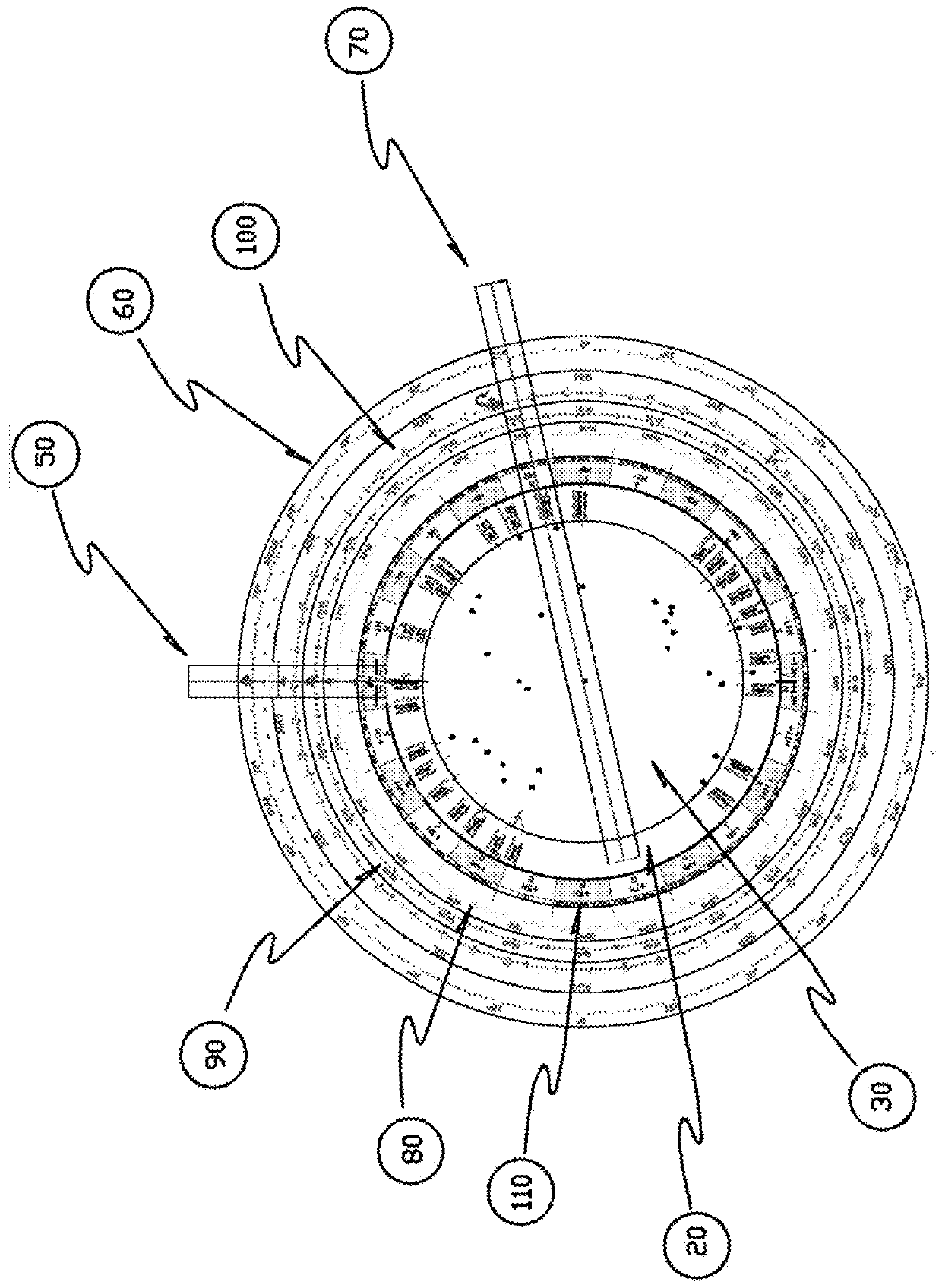
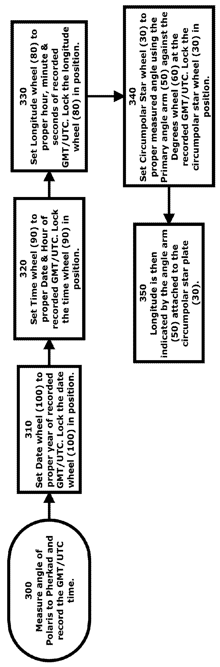
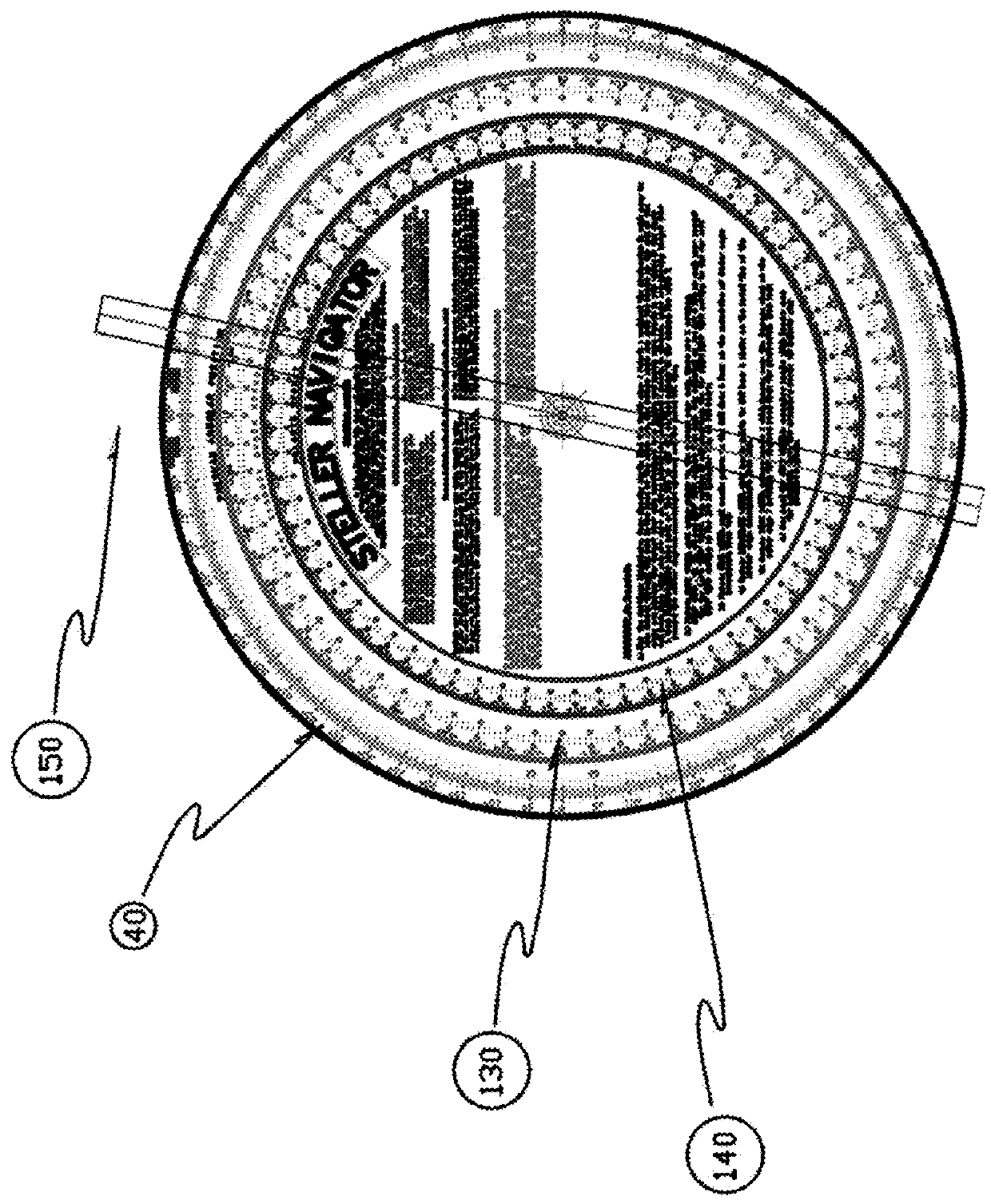
[0048]The present invention is an emergency longitude slide ruler and method of use. The emergency longitude slide ruler is a precision instrument which compares one's current observed star position in the average circumpolar region of the sky to that of the star positions along the 0° meridian (Prime meridian) at that moment in time. The computed difference leads to the local longitude figure. The present invention uses a known reference star position determined by NASA astronomical tables at a given year, date and time as the zeroing base. From this, and correlating particular positioning of the wheels (10) of the present invention, all other information is attained. In the Northern hemisphere version of the present invention, the angle refers to something measurable to be relevant. As a default, the process of use of the present invention uses the star Polaris to Pherkad angle with respect to the earth geoid surface or center of gravity. Any star could be selected to measure the ...


PUM


Abstract

A system of navigation employing an emergency longitude slide ruler for stellar navigation is described. The emergency longitude slide ruler is equipped with several wheels having rulers with settings including of the longitude slide ruler of the present invention include year, date, hour, minutes, star angle measurement degree wheel, a longitude wheel, a circumpolar star field identifier wheel, star meridian transit angles wheel, and a time zone wheel. All wheels are of diminishing diameters and are laid on top of each other in descending circumference with minute gradations allowing each consecutive wheel to line up with its larger adjacent wheel according to proper settings to eventually indicate longitude. The system presents an efficient and expedient means by which an individual with very limited knowledge of navigation and celestial bodies can determine his or her location, including longitude.

Description

[0001]This application is a non-provisional application of Provisional Patent Application No. 62 / 311,144, filed on Mar. 21, 2016, and priority is claimed thereto.FIELD OF THE PRESENT INVENTION[0002]The present invention relates to navigational tools, and more specifically relates to a tool and system configured to facilitate the navigation of an individual in emergency situations via the position of the stars in relation to one another, as opposed to standard Celestial Navigation which uses the relation between stars and the horizon. The new system is simplified and expedited through the use of an emergency longitude slide ruler utilizing only the Circumpolar region of the sky.BACKGROUND OF THE PRESENT INVENTION[0003]Conventionally, vessels such as boats, yachts, and ships are equipped with navigational equipment configured to enable the captain to navigate the seas accurately and quickly. These devices include a Loran Navigational System and a Global Positioning System (GPS) config...

Claims


Application Information

Patent Timeline
Patent Type & Authority Applications(United States)
IPC IPC(8): G01C21/02
CPCG01C21/02G06G1/0052G06G1/08G09B27/04
Inventor BELLORA, JOHN
Owner BELLORA JOHN
Why Eureka
Try Eureka