Method and system for crop recognition and boundary delineation

a crop recognition and boundary delineation technology, applied in the field of crop recognition and farm boundary delineation, can solve the problems of difficult to assess the acreage allocation of crops that may be planted with a single crop, inability to identify particular crops, and inaccessible information related to farm boundary information

Active Publication Date: 2018-12-27
IBM CORP
View PDF3 Cites 60 Cited by
  • Summary
  • Abstract
  • Description
  • Claims
  • Application Information

AI Technical Summary

Problems solved by technology

However, information related to farm boundaries is not readily available due to privacy and ownership concerns, making it difficult to assess acreage allocation that may be planted with a single crop.
Some systems can identify acreage that includes vegetation, however, such systems merely identify the general presence of vegetation and cannot identify particular crops that are planted within such acreage to delineate boundary lines between vegetated areas.

Method used


Image

  • Method and system for crop recognition and boundary delineation
  • Method and system for crop recognition and boundary delineation
  • Method and system for crop recognition and boundary delineation

Examples


Embodiment Construction

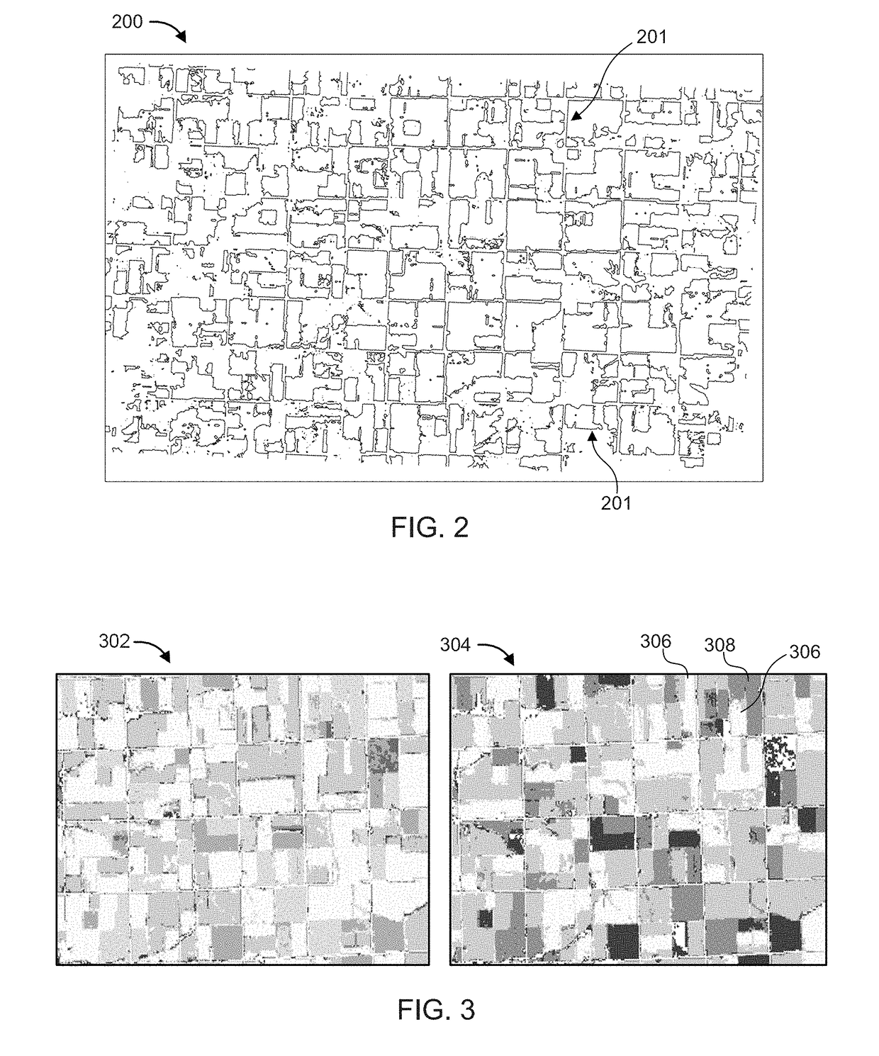
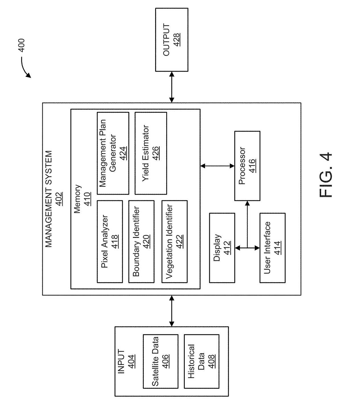
[0024]The present invention provides systems and methods to identify crop types and / or determine boundary delineations by extracting and / or evaluating satellite data and historical planting patterns. In some embodiments, the present invention can be used for identifying and evaluating, for example, crop selection, crop rotation, resource allocation, etc. In an embodiment, the systems and methods described herein allow data input by a user and / or historical planting patterns related to multiple parcels of land to provide a comprehensive farm management plan. In some embodiments, the present invention can be used for identifying boundary delineations using satellite data, such as normalized difference vegetation index (NDVI) values, which distinguishes land areas that include vegetation from non-vegetated areas in addition to identifying varying crop types within vegetated regions.

[0025]Exemplary applications / uses to which the present invention can be applied include, but are not limi...


PUM


Abstract

A computer-implemented method for determining farm boundary delineations within a target geographic area, comprising extracting data from pixels of a satellite image of the target geographic area, evaluating the data using a classification algorithm to generate one or more line segments between adjacent pixels, the one or more line segments being representative of a portion of a boundary delineation, connecting the one or more line segments to an adjacent line segment to form a boundary delineation defining at least one parcel of land within the target geographic area, and generating a boundary delineation map including the boundary delineation.

Description

BACKGROUNDTechnical Field[0001]The present invention generally relates to crop recognition and farm boundary delineation, and more particularly to analyzing satellite data and historical planting patterns to determine boundary delineations.Description of the Related Art[0002]Farmers use a variety of methods to determine what crops to grow for a given amount of land, especially as various factors effect crop selection. For example, environmental factors (e.g., climate characteristics, soil characteristics, weather, etc.) constrain crop selection, as certain crops must be planted at certain times of the year and / or during specific climate conditions. In some instances, only certain types of crops and / or rotation patterns are feasible for a particular plot of land to increase economic benefits. In addition, market conditions (e.g., market demands, resource availability, market prices, etc.) often influence crop selection and acreage allocation (e.g., the amount of land devoted to a spe...

Claims


Application Information

Patent Timeline
Patent Type & Authority Applications(United States)
IPC IPC(8): G06K9/00G06T7/13G06F17/14G01J3/28
CPCG06K9/00657G06T7/13G06F17/14G01J3/2823G01J2003/2826G06T2207/20084G06T2207/10036G06T2207/30188G06T7/11G06V20/188G06V10/82
Inventor ALBRECHT, CONRAD M.LU, SIYUANMARIANNO, FERNANDO J.HAMANN, HENDRIK F.FREITAG, MARCUS O.KLEIN, LEVENTE I.
Owner IBM CORP
Why Eureka
Try Eureka