Eureka AIR delivers breakthrough ideas for toughest innovation challenges, trusted by R&D personnel around the world.

Three-dimensional digital virtual imaging device and method for stratigraphic texture of borehole core

a digital virtual imaging and stratigraphic texture technology, applied in the field of geotechnical engineering survey and construction, can solve the problems of not meeting the technical requirements of geological exploration, the stratigraphic texture of the borehole cannot be measured, and the geological structure measurement often appears different from the actual one, so as to improve the level of geological exploration technology and

Active Publication Date: 2019-03-21
WUHAN CONOURISH COALMINE SAFETY TECH +1
View PDF2 Cites 2 Cited by
  • Summary
  • Abstract
  • Description
  • Claims
  • Application Information

AI Technical Summary

Benefits of technology

The invention is a device that can create videos and images of underground boreholes. It can capture images from all angles and in high definition. The device can also analyze the textures of the core of the borehole to improve geological exploration technology and make the results data more accessible to users. Overall, the invention improves the level of geological exploration and invention technology by providing detailed and easily understandable information about underground boreholes.

Problems solved by technology

Most of the traditional borehole TV imager are borehole video recorder which cannot generate digital virtual borehole image, and cannot measure the borehole stratigraphic texture.
With the improving requirements of geological exploration, the borehole video recorder cannot meet the technical requirements of geological exploration.
However, in some borehole exploration, the borehole is often easy to be tilted and the borehole trajectory may change, resulting in that the geological structure measurement often appears different from the actual one.

Method used


Image

  • Three-dimensional digital virtual imaging device and method for stratigraphic texture of borehole core
  • Three-dimensional digital virtual imaging device and method for stratigraphic texture of borehole core

Examples


Embodiment Construction

[0020]The present invention will be further described in detail below with reference to the accompanying drawings and specific embodiments.

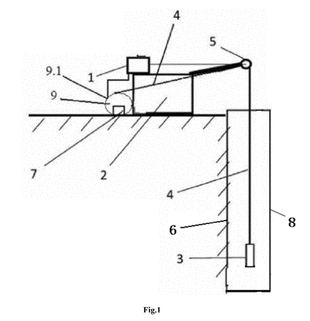
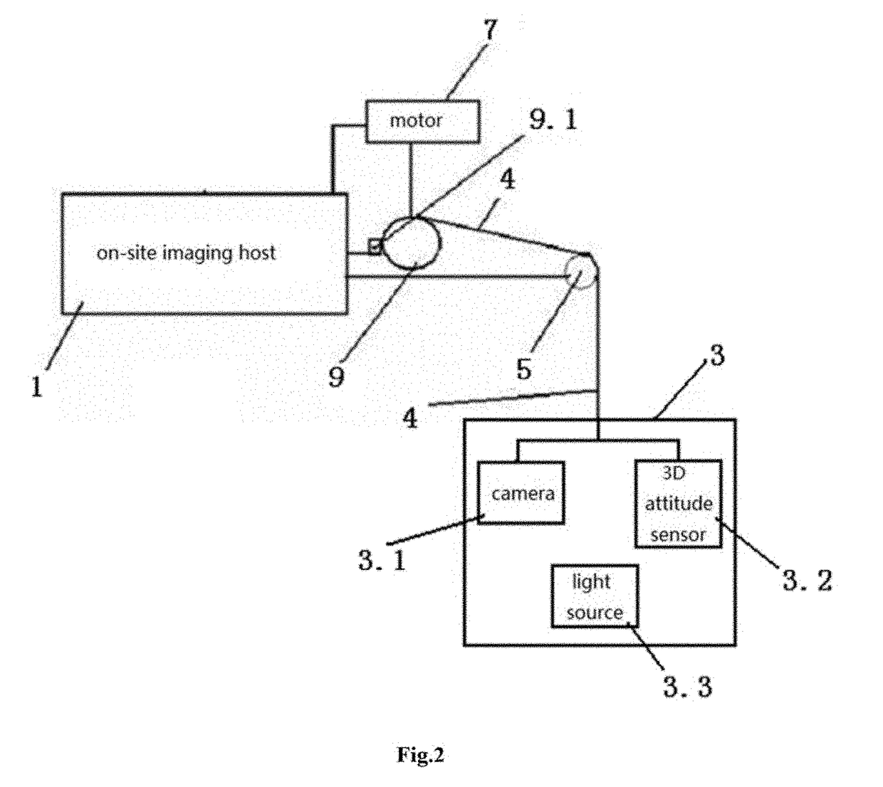
[0021]The invention provides a three-dimensional digital virtual imaging device for stratigraphic texture of borehole core, comprising an on-site imaging host 1, a lifting wire frame 2, a borehole imaging trajectory measuring probe 3, a cable 4, a probe depth counting pulley 5, a motor 7 and a retractable reel 8. The probe depth counting pulley 5 is mounted on the lifting wire frame 2, the output shaft of the motor 7 is configured to drive the reel 9 to rotate, one end of the cable 4 is connected to the cable transfer node 9.1 of the retractable reel 9, the signal input end for the borehole imaging trajectory measuring probe of the on-site imaging host 1 is electrically connected to one end of the cable 4 through the cable transfer node 9.1 of the retractable reel 9, the cable 4 is wound on the retractable reel 9, a retractable line is controlled...


PUM


Abstract

Disclosed is a three-dimensional digital virtual imaging device for stratigraphic texture of borehole core, wherein the probe depth counting pulley is mounted on the lifting wire frame, the output shaft of the motor is configured to drive the reel to rotate, and one end of the cable is connected to the cable transfer node of the retractable reel, the signal input end of the borehole imaging trajectory measuring probe of the on-site imaging host is electrically connected to one end of the cable through the cable transfer node of the retractable reel, the cable is wound on the retractable reel, a retractable line is controlled by the retractable reel, the cable is extended and retracted on the probe depth counting pulley, the probe depth counting pulley records the length of the retractable line of the cable, the depth feedback signal output end of the depth counting pulley is connected to the depth feedback signal input end of the on-site imaging host, the motor control signal output end of the on-site imaging host is connected to the control signal input end of the motor, and the signal output end of the borehole imaging trajectory measuring probe is connected to the other end of the cable. It can automatically generate borehole video, two-dimensional digital virtual borehole core image and 3D borehole trajectory in real time.

Description

CROSS-REFERENCE TO RELATED APPLICATIONS[0001]The present application claims priority from Chinese patent Application No. CN201710897005.2 filed on Sep. 28, 2017, the entire contents of which are incorporated herein by reference.FIELD OF THE INVENTION[0002]The invention relates to the technical field of geotechnical engineering survey and construction, in particular to a three-dimensional digital virtual imaging device and method for stratigraphic texture of borehole core.BACKGROUND[0003]The Ministry of Construction of China has advocated the acceleration of the transformation of traditional industries with high-tech and advanced applicable technology in the “Key Elements of Industrial Exploration Technological Progress and Technical Policy (issued as [2003]-202)”, and focused on the promotion of high-definition digital panoramic borehole imaging system applied in hydrology and geological survey work.[0004]The Ministry of Land and Resources of China has decided to carry out geologica...

Claims


Application Information

Patent Timeline
Patent Type & Authority Applications(United States)
IPC IPC(8): G01V8/02H04N5/232H04N7/18H04N5/225
CPCG01V8/02H04N5/23238H04N7/185H04N5/2253H04N2005/2255G01V3/083G01V2003/084H04N23/555H04N23/698H04N23/54G01V2003/085
Inventor WU, QIANGLIU, LIUZENG, YIFANTAO, FENGJUANLIU, CHUNSHENG
Owner WUHAN CONOURISH COALMINE SAFETY TECH
Why Eureka
Eureka Blog
Learn More