
Crop boundary detection in images

a technology of crop boundary and image, applied in image enhancement, instruments, biological models, etc., can solve the problems of inconsistent, inaccurate, out of date, and/or otherwise incomplete data for many practical uses, and the accuracy of agricultural land data is not reliable, consistent, and/or precise identification of all agricultural fields within a geographical region, county, state, etc. and the accuracy of crop boundary detection is not good

Active Publication Date: 2019-07-25
MINERAL EARTH SCI LLC
View PDF0 Cites 16 Cited by
  • Summary
  • Abstract
  • Description
  • Claims
  • Application Information

AI Technical Summary

Benefits of technology

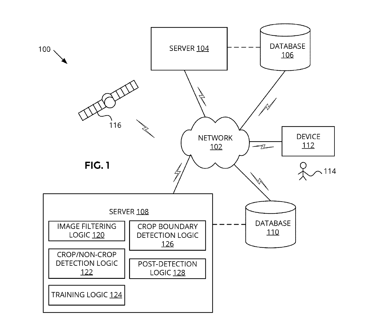
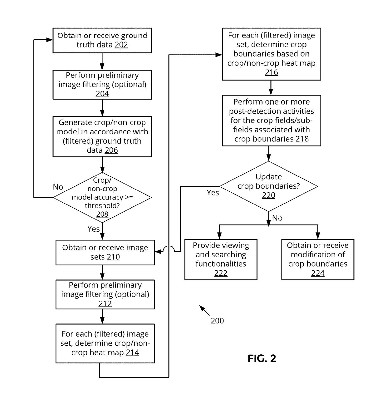
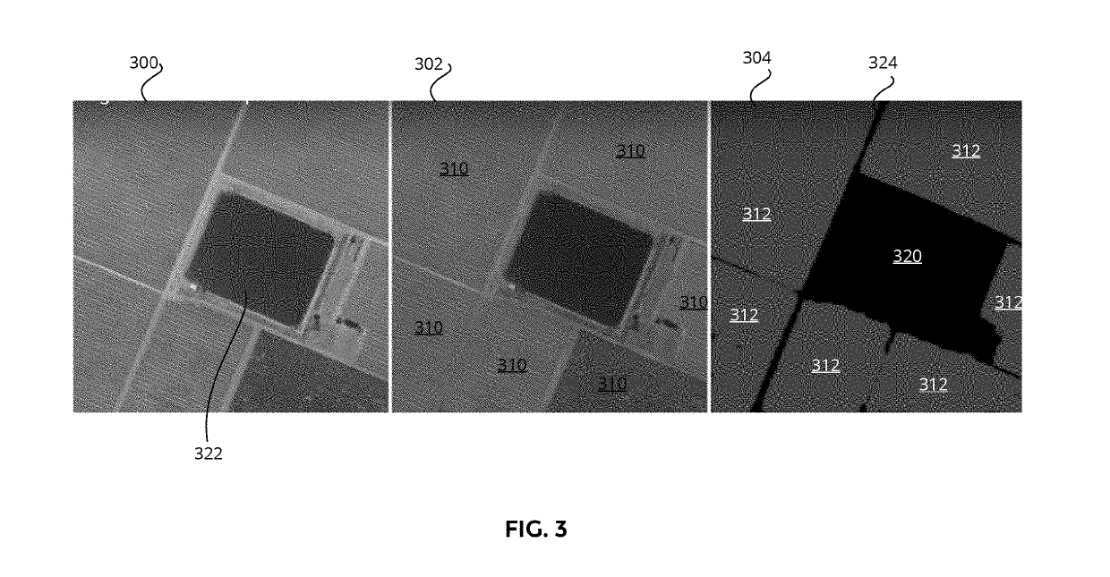
The patent describes a system, method, and apparatus for detecting the boundaries of crop fields in images. This technology uses multi-spectral and time series images to predict the presence of crop at specific locations and determine the boundaries of crop fields. The system can be used to improve agricultural land use and decision-making for seed and fertilizer companies, crop insurance companies, banks, and governments. The technical effect of this technology is to provide a reliable and cost-effective way to identify and map agricultural lands, which is currently an incomplete and incomplete task.

Problems solved by technology

Despite the importance of agriculture for human survival, environmental impact, national implications, commercial enterprises, the markets, and the like, there is no consistent, reliable, and / or precise identification of all the agricultural fields within a geographical region, county, state, country, continent, planet wide, or portions of any of the above.
To the extent that mapping data related to agricultural land may exist, such data tends to be inconsistent, inaccurate, out of date, and / or otherwise incomplete for many practical uses.
Due to the labor-intensive nature of gathering such data, the agricultural land data tends to be updated infrequently (or too infrequently for many commercial purposes).

Method used


Image

  • Crop boundary detection in images
  • Crop boundary detection in images
  • Crop boundary detection in images

Examples


Embodiment Construction

[0013]Embodiments of a system, apparatus, and method for crop boundary detection in images are described herein. In some embodiments, a method includes obtaining a plurality of image sets associated with a geographical region and a time period, wherein each image set of the plurality of image sets comprises multi-spectral and time series images that depict a respective particular portion of the geographical region during the time period; predicting presence of a crop at particular locations within the particular portion of the geographical region associated with an image set of the plurality of image sets; determining crop boundary locations within the particular portion of the geographical region based on the predicted presence of the crop at the particular locations; and generating a crop indicative image comprising at least one image of the multi-spectral and time series images of the image set overlaid with indication of crop areas, wherein the crop areas are defined by the dete...


PUM


Abstract

In embodiments, obtaining a plurality of image sets associated with a geographical region and a time period, wherein each image set of the plurality of image sets comprises multi-spectral and time series images that depict a respective particular portion of the geographical region during the time period, and predicting presence of a crop at particular locations within the particular portion of the geographical region associated with an image set of the plurality of image sets. Determining crop boundary locations within the particular portion of the geographical region based on the predicted presence of the crop at the particular locations, and generating a crop indicative image comprising at least one image of the multi-spectral and time series images of the image set overlaid with indication of crop areas, wherein the crop areas are defined by the determined crop boundary locations.

Description

CROSS-REFERENCE TO RELATED APPLICATIONS[0001]The present application claims priority to U.S. Provisional Patent Application No. 62 / 620,908 filed Jan. 23, 2018, the disclosure of which is incorporated herein by reference in its entirety.TECHNICAL FIELD[0002]This disclosure relates generally to image feature detection, and in particular but not exclusively, relates to use of machine learning in image feature detection.BACKGROUND INFORMATION[0003]Approximately 11% of earth's land surface is presently used in crop production. Despite the importance of agriculture for human survival, environmental impact, national implications, commercial enterprises, the markets, and the like, there is no consistent, reliable, and / or precise identification of all the agricultural fields within a geographical region, county, state, country, continent, planet wide, or portions of any of the above. If more information about agricultural fields were known, seed and fertilizer companies, for example, may bet...

Claims


Application Information

Patent Timeline
IPC IPC(8): G06K9/00G06N3/08G06T7/11A01B79/00G06Q50/02
CPCG06K9/00657G06N3/08G06T7/11A01B79/005G06Q50/02G06T2207/30188G06T2207/20081G06K2209/17G06N20/00G06T7/77G06T2207/10032G06T2207/10036G06T2207/10024G06T2207/10048G06T2207/20084G06V20/188G06N3/045G06V20/68
Inventor GUO, CHENG-ENYANG, JIEGRANT, ELLIOTT
Owner MINERAL EARTH SCI LLC
Learn More