Method for achieving space-based autonomous navigation of global navigation satellite system (GNSS) satellites

a global navigation satellite and satellite technology, applied in the field of satellite navigation technologies, can solve the problems of slow change of conventional satellite-ground measurement geometry, affecting the positioning and timing accuracy of navigation satellites, and affecting the accuracy of navigation signals, so as to reduce orbital maintenance costs and facilitate navigation calculation. , the effect of long-term stability

Active Publication Date: 2020-10-08
TECH & ENG CENT FOR SPACE UTILIZATION CHINESE ACAD OF SCI
View PDF4 Cites 21 Cited by
  • Summary
  • Abstract
  • Description
  • Claims
  • Application Information

AI Technical Summary

Benefits of technology

[0059](2) The selected DRO is 330,000 to 440,000 km away from the earth, with a large observation field of view. At the same time, the DRO has long-term stability and is expected to greatly reduce orbital maintenance costs.
[0060](3) The period of LEO satellite is short, the geometric range between the LEO satellite

Problems solved by technology

1) Delay effects of a troposphere and an ionosphere on navigation signals
Navigation signals are subjected to delay effects in the atmospheric troposphere and ionosphere during the propagation to the ground.
Although the delay amount is also calculated as a data product in the ground analysis process, the decrease in the meas

Method used


Image

  • Method for achieving space-based autonomous navigation of global navigation satellite system (GNSS) satellites
  • Method for achieving space-based autonomous navigation of global navigation satellite system (GNSS) satellites
  • Method for achieving space-based autonomous navigation of global navigation satellite system (GNSS) satellites

Examples


embodiment 1

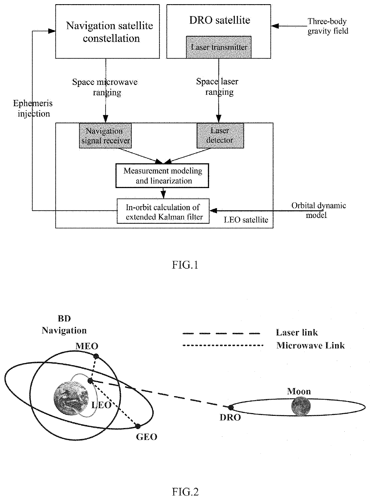
[0079]This embodiment provides a method for achieving GNSS-based autonomous navigation of a space segment satellite, as shown in FIG. 1, including the following steps.

[0080]S1: Optimize an earth-moon space DRO, and establish a dynamic model of an earth-moon space satellite orbit.

[0081]S2: Establish measurement links, by an LEO data relay satellite, with an earth-moon space DRO satellite and a GNSS satellite respectively, and measure an inter-satellite distance for modeling and linearization.

[0082]S3: Adopt an extended Kalman filter (EKF) method to process inter-satellite measurement data, and autonomously determine a position and velocity of the GNSS without depending on the ground measurement and control support.

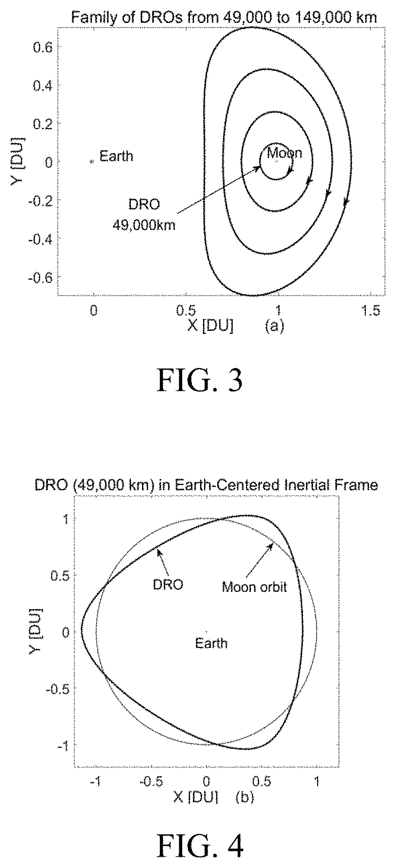
[0083]Specifically, earth-moon DROs with periodic characteristics are deduced from a CRTBP model. DROs are usually expressed in an earth-moon rotating coordinate system, the origin is the earth-moon center of mass, the X axis points from the center of the earth to the cente...

embodiment 2

[0117]In this embodiment, the steps of the method in Embodiment 1 are used to perform simulation scene experiment determination:

[0118]The simulation time is set at 0:00 on Jan. 1, 2018 (UTC time), and the simulation time is 14 days. A DRO preferred in Embodiment 1 is selected, with a plane amplitude of 49000 km in the earth-moon rotating coordinate system. Table 1 gives an initial state of the DRO in an earth-centered inertial J2000 coordinate system. The LEO orbit selected is a nearly circular orbit with an altitude of 400 km and an inclination angle of 43°. The initial state is shown in Table 2.

TABLE 1Initial state of DROs in a J2000 coordinate systemX [km]Y [km]Z [km]Vx [km / s]Vy [km / s]Vz [km / s]−20018.812298708.811126160.3201.2636560.1987100.182677

TABLE 2Initial value state of orbits of LEO data relay satellitesRight Semi-ascensionArgument majorInclinationof ascendingofTrueaxisEccen-anglenodeperigeeanomaly[km]tricity[deg][deg][deg][deg]LEO6778.1400.00243.00.00.00.0

[0119]Taking a G...


PUM


Abstract

Disclosed is a method for achieving space-based autonomous navigation of global navigation satellite system (GNSS) satellites, and relates to the field of satellite navigation technologies. The method includes the following steps: optimizing a DRO, and establishing a dynamic model of an earth-moon space satellite orbit; establishing measurement links, by a low earth orbit (LEO) data relay satellite, with an earth-moon space DRO satellite and a GNSS respectively, and measuring an inter-satellite distance for modeling and linearization; adopting an extended Kalman filter (EKF) method to process inter-satellite measurement data, and autonomously determining a position and velocity of the global navigation satellite system without depending on the ground measurement and control support.

Description

CROSS-REFERENCE TO RELATED APPLICATIONS[0001]This application claims priority under 35 U.S.C. § 119(b) to Chinese Application No. 201910263156.1, filed Apr. 2, 2019, the disclosure of which is incorporated by reference herein in its entirety.TECHNICAL FIELD[0002]The present invention relates to the field of satellite navigation technologies, and in particular, to a method for achieving space-based autonomous navigation of global navigation satellite system (GNSS) satellites.BACKGROUD OF THE INVENTION[0003]At present, a GNSS includes a GPS navigation constellation, a Beidou navigation constellation, a Glonass navigation constellation, and the like, and provided positioning and timing services have been widely used in various fields such as agriculture, industry and commerce, national defense, and people's livelihood. The satellite navigation system generally includes three parts: a space segment, a ground segment and a user segment. A main body of the space segment is a certain numbe...

Claims


Application Information

Patent Timeline
IPC IPC(8): G01S19/39B64G1/10G01S19/42G06F17/13G06F17/16
CPCG01S19/421B64G1/1014G06F17/13G06F17/16G01S19/393B64G1/1007G01S19/02B64G1/242B64G1/1085
Inventor WANG, WENBINGAO, YANGSHU, LEIZHENGLIU, JIANGKAI
Owner TECH & ENG CENT FOR SPACE UTILIZATION CHINESE ACAD OF SCI
Why Eureka
Try Eureka