Crowd sourced beacon altitudes for 3D positioning
a beacon and altitude technology, applied in the field of user equipment (ue) positioning, can solve the problems of insufficient use cases, low accuracy of existing techniques, and often three-time horizontal error,
- Summary
- Abstract
- Description
- Claims
- Application Information
AI Technical Summary
Benefits of technology
Problems solved by technology
Method used
Image

Examples
first embodiment
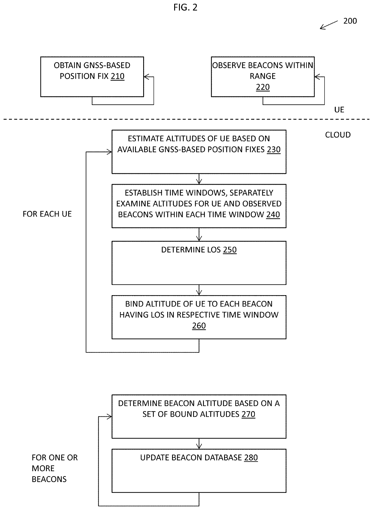
[0020]In a first embodiment, the 3D positioning client 126 on UE 110 and the z-axis positioning server 146 of the 3D positioning platform 140 implement a GNSS-based crowd-sourcing technique to determine beacon altitudes that may then be used in 3D positioning of UE 110. FIG. 2 is a flow diagram of an example sequence of steps 200 for GNSS-based crowd-sourcing of beacon altitudes. Steps 210-220 may be performed in parallel on each of a large number of UE 110 to crowd source information. Steps 230-280 may be performed on the 3D positioning platform 140 in the cloud to aggregate the crowd-sourced information.
[0021]At step 210, on each UE 110, the 3D positioning client 126 obtains a GNSS-based position fix for the UE determined by the native positioning engine 124 working with the GNSS receiver 136. The GNSS-based position fix may be obtained periodically, in response to requests by the 3rd party applications 128, in response to requests by the 3D positioning client 126, and / or in respo...
second embodiment
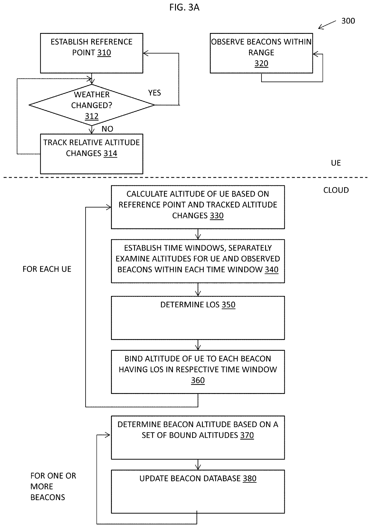
[0033]In a second embodiment, the 3D positioning client 126 on UE 110 and the z-axis positioning server 146 of the 3D positioning platform 140 in the cloud implement an uncalibrated pressure-based crowd-sourcing technique to determine beacon altitudes that may then be used in 3D positioning of UE. FIG. 3A is a flow diagram of an example sequence of steps 300 for uncalibrated pressure-based crowd-sourcing of beacon altitudes. To better understand the steps 300 of FIG. 3A, reference is also made to FIG. 3B, which is diagram 385 illustrating an example of uncalibrated altitude determination that may be used in crowd-sourcing of beacon altitudes. Steps 310-320 may be performed in parallel on each of a large number of UE 110 to crowd source information. Steps 330-380 may be performed on the 3D positioning platform 140 in the cloud to aggregate the crowd-sourced information.
[0034]At step 310, on each UE 110, the 3D positioning client 126 establishes a reference point that includes a refer...
third embodiment
[0050]In a third embodiment, the 3D positioning client 126 on UE 110 and the z-axis positioning server 146 of the 3D positioning platform 140 in the cloud implement a combined beacon altitude crowd-sourcing and pressure sensor calibration technique. Using such a technique beacon altitudes can be obtained to enable 3D positioning via (e.g., by trilateration, multilateration or other positioning techniques) while 3D positioning also be performed using calibrated pressure measurements. FIG. 4 is a flow diagram of an example sequence of steps 400 for a combined beacon altitude crowd-sourcing technique and pressure sensor calibration technique. Steps 410-420 may be performed in parallel on each of a large number of UE 110 to crowd source information. Steps 430-494 may be performed on the 3D positioning platform 140 in the cloud to aggregate the crowd-sourced information.
[0051]At step 410, on each UE 110, the 3D positioning client 126 obtains a GNSS-based position fix for the UE determine...
PUM
 Abstract
Description
Claims
Application Information
 - R&D
- Intellectual Property
- Life Sciences
- Materials
- Tech Scout
- Unparalleled Data Quality
- Higher Quality Content
- 60% Fewer Hallucinations
Browse by: Latest US Patents, China's latest patents, Technical Efficacy Thesaurus, Application Domain, Technology Topic, Popular Technical Reports.
© 2025 PatSnap. All rights reserved.Legal|Privacy policy|Modern Slavery Act Transparency Statement|Sitemap|About US| Contact US: help@patsnap.com