Mapping system for the integration and graphical display of pipeline information that enables automated pipeline surveillance

a mapping system and information technology, applied in the field of pipeline mapping system, can solve the problems of pipeline contents being released into the surrounding environment, pipeline defects and anomalies, and corrosion of pipelines

Inactive Publication Date: 2001-06-05
PII NORTH AMERICA
View PDF32 Cites 137 Cited by
  • Summary
  • Abstract
  • Description
  • Claims
  • Application Information

AI Technical Summary

Benefits of technology

Pipeline data from several sources, can also be integrated. The present invention provides for automated pipeline surveillance without requiring routine, periodic surveillance from an airplane or helicopter traversing the pipeline route. This reduces surveillance costs and alleviates safety concerns for those persons performing the aerial surveillance.

Problems solved by technology

Environmental factors or transported products may result in, among other things, pipeline corrosion.
Pipeline corrosion, if not detected and remedied, can result in release of a pipeline's contents into a surrounding environment.
Soil subsidence, local construction projects, seismic activity, weather, and degradation caused by normal use can also lead to defects and anomalies in a pipeline.
In addition, harsh environments can cause pipelines to move gradually over time thus making later detection of buried pipelines difficult.
These shifts in the pipeline location can also lead to defects, cracks, leaks, bumps, and other anomalies in the pipeline.
The internal and external surface walls of a pipeline are susceptible to damage by various factors.
Moreover, submarine pipelines face additional hazards which include ship anchors, troll boards, and seabed scouring due to strong currents.
While timely repair or maintenance of pipelines can lengthen the service lifetime of the pipeline, a rupture or serious leak within the pipeline can be difficult and expensive to repair.
Further, in the early stages the exact position of the rupture may be difficult to locate.
Identifying these faults in a buried pipeline is problematic when the location of the buried pipeline cannot be readily ascertained.
As previously stated, many of the environmental stresses on the pipeline that cause defects and anomalies to appear in the pipeline can also shift the pipeline location.
A disadvantage of aerial surveillance arises from its cost and concern for the safety of the persons performing the aerial surveillance.
The cost of this technique in terms of personnel and time is very high.
Again, pipeline survey crews were expensive and the task was time consuming.
Satellite imaging systems have been available for a number of years, but high resolution images have not been commercially available.

Method used


Image

  • Mapping system for the integration and graphical display of pipeline information that enables automated pipeline surveillance
  • Mapping system for the integration and graphical display of pipeline information that enables automated pipeline surveillance
  • Mapping system for the integration and graphical display of pipeline information that enables automated pipeline surveillance

Examples


Embodiment Construction

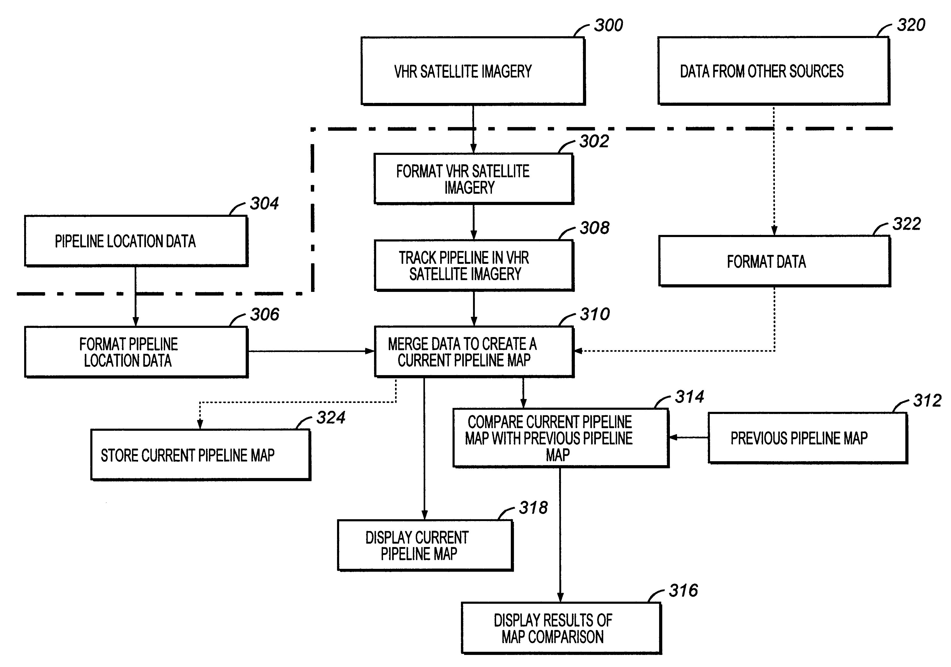
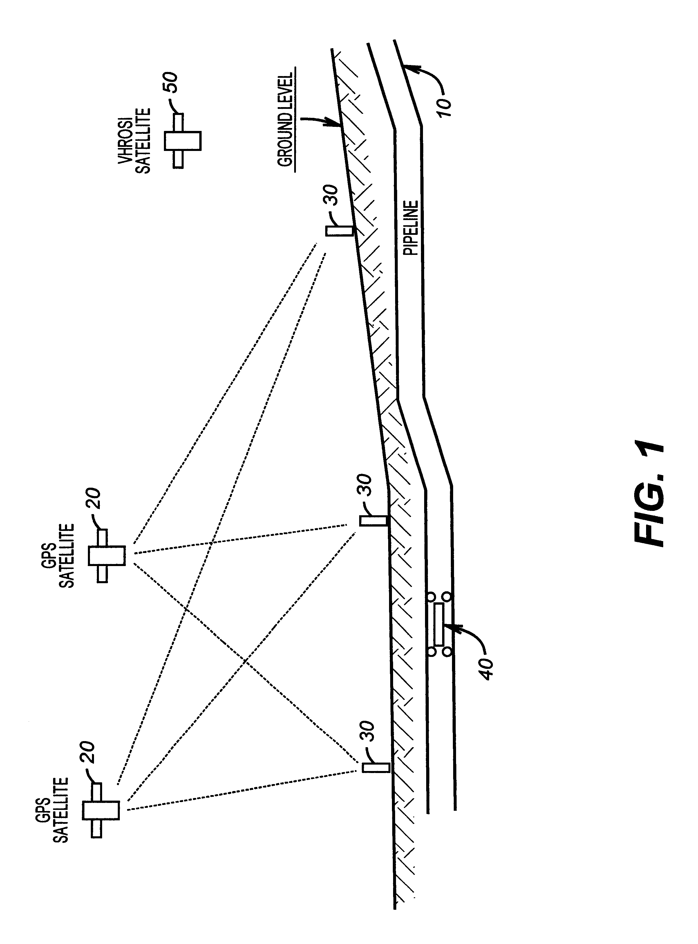
The present invention provides a pipeline mapping system implemented in a computer system that utilizes pipeline data and satellite data to provide automated surveillance for a pipeline. The satellite data is integrated with the pipeline data to produce a current pipeline map. The current pipeline map can then be compared with a previous pipeline map to determine whether the route of the pipeline or a surrounding environment of the pipeline has changed. In a disclosed embodiment, the satellite data is very high resolution (VHR) satellite imagery and the pipeline data includes location data that is a series of global positioning system (GPS) coordinates. The present invention provides for pipeline surveying or surveillance without requiring routine, periodic surveillance from an airplane or helicopter traversing the pipeline route. This reduces surveillance costs and alleviates safety concerns for those persons performing the aerial surveillance.

Pipeline Location Data

The preferred te...


PUM


Abstract

Pipeline data and satellite data are used to provide surveillance for a pipeline. The satellite data is integrated with the pipeline data to produce a current pipeline map. The current pipeline map is then compared with a previous pipeline map to determine whether the route of the pipeline or a surrounding environment of the pipeline has changed. The satellite data includes very high resolution (VHR) satellite imagery and the pipeline data includes location data that is a series of global positioning system (GPS) coordinates.

Description

Not applicable.Not applicable.1. Field of the InventionThe present invention relates to a pipeline mapping system for comparing and graphically displaying integrated pipeline information without the need for ongoing, periodic aerial surveillance.2. Description of the Related ArtPipelines are widely used in a variety of industries and allow material to be transported from one location to another. A variety of fluids such as oil, gas, particulates, and other small solids suspended in fluids are transported using pipelines. In a typical application a pipeline carries a large quantity of oil products under pressure. Frequently, pipelines carry these products at high temperature and at high flow rates. Many pipelines are also routed through environments and carry products that affect the vitality of the pipeline. Environmental factors or transported products may result in, among other things, pipeline corrosion.Pipeline corrosion, if not detected and remedied, can result in release of a ...

Claims


Application Information

Patent Timeline
Patent Type & Authority Patents(United States)
IPC IPC(8): F17D5/00G01S5/14G01S19/21G01S19/41
CPCF17D5/00G01S19/41
Inventor PETROU, MARIAFRASER, ANDY J.HEWITT, BRIANTUCK, ALAN
Owner PII NORTH AMERICA
Why Eureka
Try Eureka