Navigation device and method of use having two separate route searching devices

a navigation device and route search technology, applied in the direction of navigation instruments, direction finders using radio waves, instruments, etc., can solve the problems of requesting a route search to the information center, affecting the accuracy of the display, and requiring communication costs

Inactive Publication Date: 2003-12-09
TOYOTA JIDOSHA KK
View PDF20 Cites 130 Cited by
  • Summary
  • Abstract
  • Description
  • Claims
  • Application Information

AI Technical Summary

Benefits of technology

It is also preferable that the route is searched on a plurality of conditions for an optimal route and the search selecting device determines the route searching device for each of the plurality of conditions. By searching on a plurality of conditions, the user can be notified of the optimal route for each condition, and can select the route set from these conditions. By determining the searching device considering factors such as the search load, all the search result can be quickly obtained.
It is also preferable that the map matching device performs map matching using the map data maintained at the mobile body for normal situations, and performs map matching by adding guide route data obtained from the information center as a matching candidate when the detected position of the mobile body is off the roads in the map data. By adding the route data as a candidate only when the mobile body is off-route, the route data can be considered only when necessary, allowing for execution of a suitable map matching process.

Problems solved by technology

Because of this, when the detected current position is marked on a map display based on the map data, there are cases where the display is not accurate.
However, in order to communicate with the information center, lines such as a telephone line must be used, and thus, the operation involves some communication cost.
Moreover, there are cases where the information center applies fees to its service.
Therefore, a cost is incurred for requesting a route search to the information center.
In addition, because the mobile body communication usually uses wireless communication, there are cases where sufficient communication cannot be achieved due to the receiving environment for the electric wave.
However, road construction is continuously being performed, and when the map data becomes old, the vehicle may travel on a road that is not present in the map data.
In such a case, the map matching cannot be correctly performed, resulting in failure to detect the current position.
If the search is requested to the information center for each peripheral search, it is likely that the cost will be increased.
It is usually the case that a search result for roads near the current position is needed quickly and that the device should not establish communication.
When the receiving condition for the electric wave is not good, it is probable that the communication with the information center cannot be performed well and there are cases where the search result cannot be obtained.
Even when the navigation device can currently communicate, there are cases where the vehicle runs out of the area where communication is possible before obtaining the search result.
When the communication section is used for other communications, there are cases where communication with the information center is not possible.
In such a case, the navigation device will judged as off-route, and no accurate correction to the current position can be obtained.

Method used


Image

  • Navigation device and method of use having two separate route searching devices
  • Navigation device and method of use having two separate route searching devices
  • Navigation device and method of use having two separate route searching devices

Examples


first embodiment

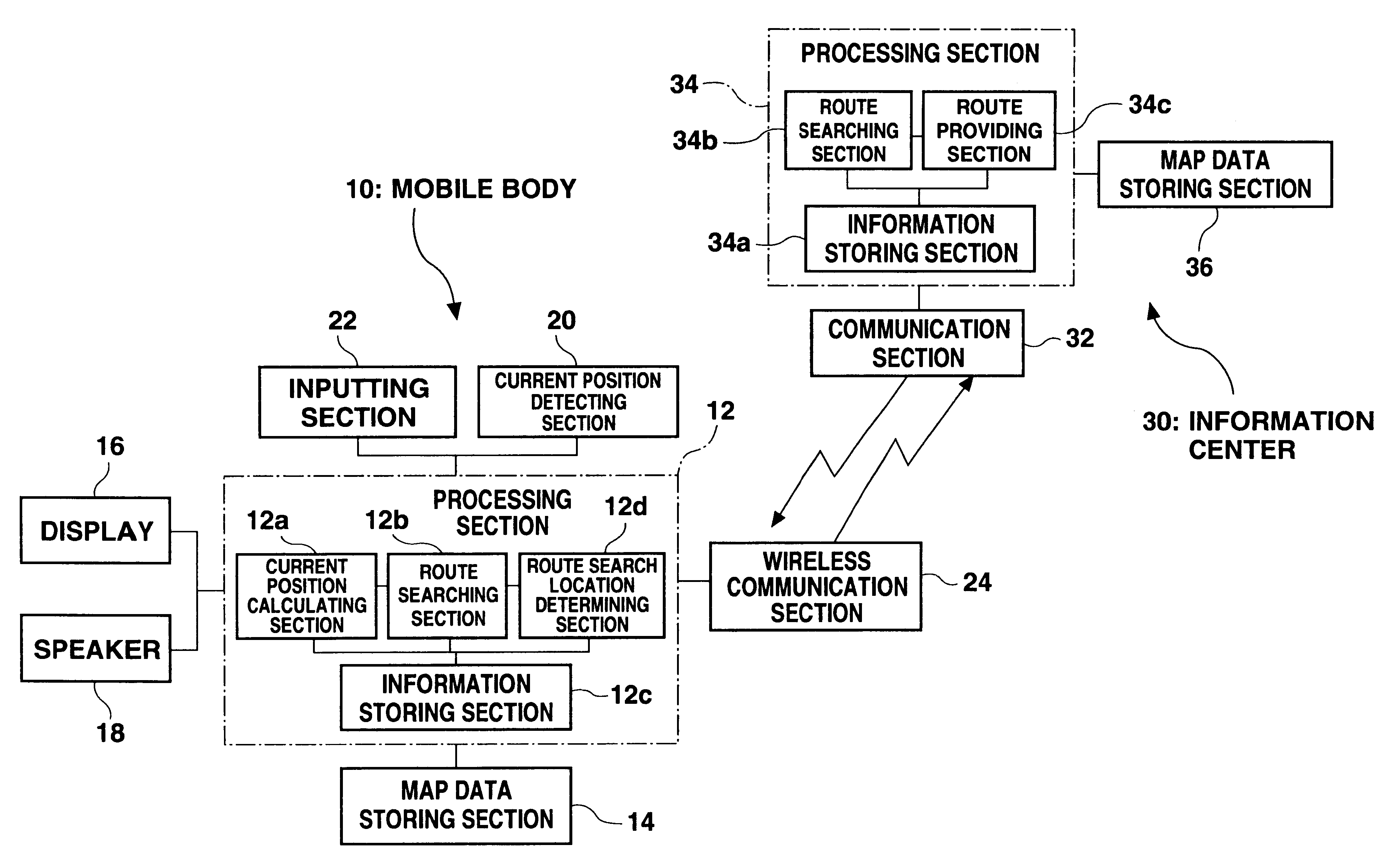
FIG. 1 is a diagram showing an overall structure of a system according to a first embodiment. A processing section 12 constructed from a computer is provided on a mobile body (vehicle) 10. A map data storing section 14 comprising storing medium such as a DVD is connected to the processing section 12. Map data is read from the map data storing section 14 and used by the processing section 12 when necessary. A display 16 such as an LCD (liquid crystal display) and a speaker 18 are connected to the processing section 12 for displaying route guidance on the display 16 and outputting a guiding voice from the speaker 18.

A current position detecting section 20 such as a GPS device is connected to the processing section 12. A current position calculating section 12a within the processing section 12 receives a signal from the current position detecting section 20, compares the signal with the map data from the map data storing section 14, and recognizes the current position of the vehicle as...

example 1-1

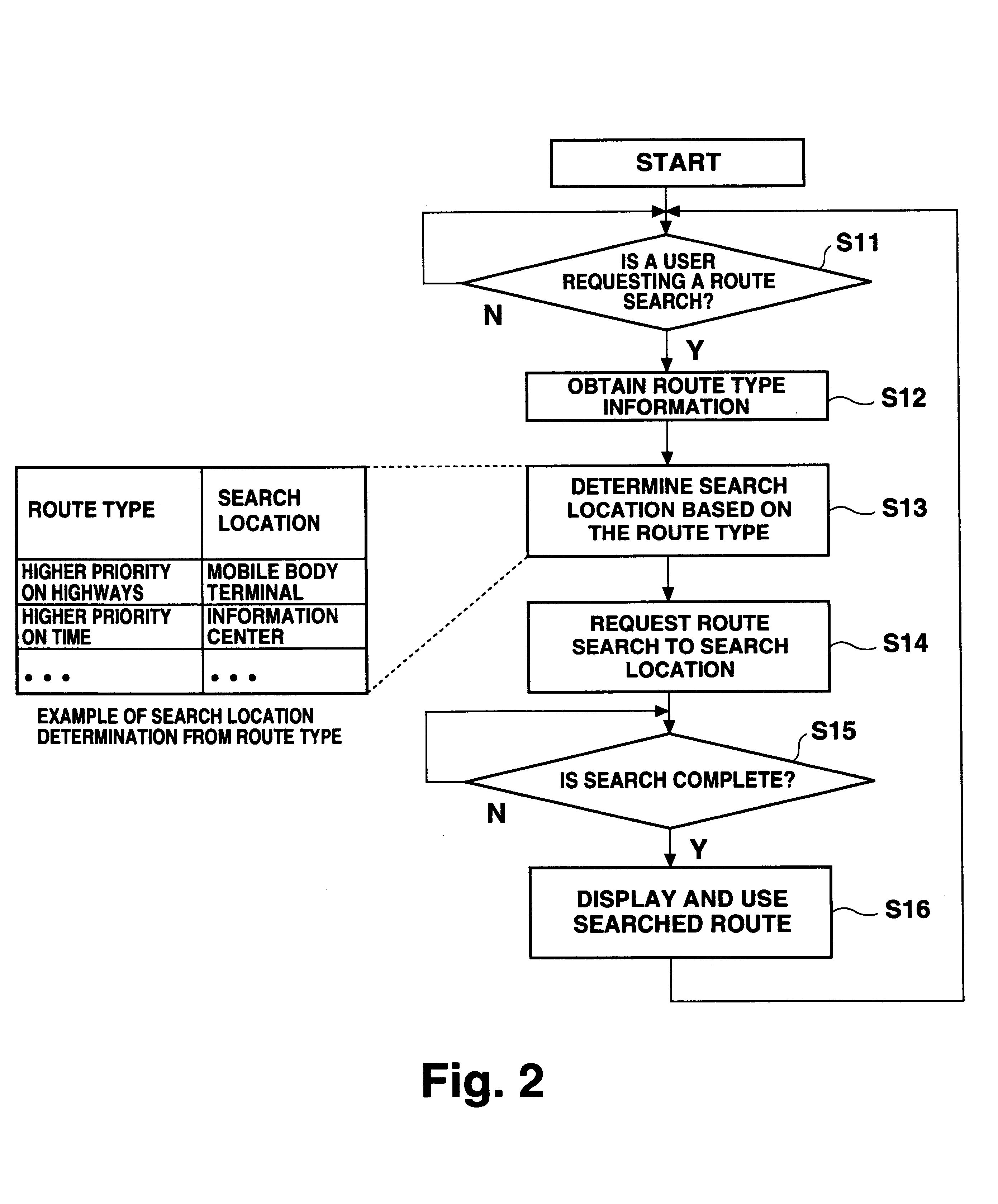
FIG. 2 is a flowchart showing an operation of the route search location deciding section 12d according to an example 1-1. In this example, the search location is determined based on the route type.

First, it is judged if there is a route search request from a user (step S11). When there is such a request, route type information is obtained (step S12). The route type information is information indicating a condition for route search such as whether to set higher priority to the highway, to the normal road, or to the travel time (shortest time), and whether to set higher priority to the distance (shortest distance) or to the cost (smallest travel expense). The route type is determined by, for example, a user input.

The search location is then determined based on the obtained route type (step S13). For example, information on the highway is usually correct even from the information on the mobile body, and thus, the route search for using the highway is conducted at the mobile body. For r...

example 1-2

FIG. 3 is a flowchart showing an operation of the route search location deciding section 12d in an example 1-2. In this example, when a plurality of routes are simultaneously searched, search location for each route is separately determined based on the route type.

First, it is judged whether there is a route search request from a user (step S21). Then, when there is such a request, route type information is obtained as route search information (step S22). The route type is similar to the above example, and is information such as whether to set higher priority to the highways. In this example, a plurality of searches for a plurality of route types are conducted in parallel according to, for example, the user setting. Then, route search loads for each of the search based on a plurality of route types are estimated (step S23). For example, the load for the route search can be obtained by pre-storing numbers such as 10 for priority on the highway, 20 for priority on the normal road, and...


PUM


Abstract

A route search location determining section (12d) of a mobile body (10) decides whether to conduct a route search at the mobile body (10) or to request the route search to an information center (30) based on various conditions such as priorities and how old the map data version is. In this manner, effective search can be conducted using two distinct route searching devices. Also, a current position calculating section (12a) can execute map matching by adding route data obtained from the information center (30) as a map matching candidate.

Description

1. Field of the InventionThe present invention relates to a navigation device mounted on a mobile body for executing route guidance, and in particular to a navigation device which can obtain route data from an outside information center.2. Description of the Related ArtA navigation device is known for executing route guidance in a vehicle. The navigation device includes a current position detecting section such as a GPS device and a map database. The navigation device recognizes the current position of the vehicle on a map and displays this information on a display. The navigation device also searches, upon inputting a destination, the best route from the current position to the destination. Moreover, if the route is set while the vehicle is traveling, the navigation device gives guidance such as turning right or left at an intersection, in addition to displaying the route on the display.Some of the navigation devices communicate with an outside information center to obtain informat...

Claims


Application Information

Patent Timeline
Patent Type & Authority Patents(United States)
IPC IPC(8): G01C21/34G01C21/00G01S19/48G08G1/09G08G1/137
CPCG01C21/34
Inventor TADA, AKIHITOSUGIMOTO, HIRONOBUYURIMOTO, MASAYUKI
Owner TOYOTA JIDOSHA KK
Why Eureka
Try Eureka