Intelligent road and rail information systems and methods

a road and rail information system and intelligent technology, applied in traffic control systems, navigation instruments, instruments, etc., can solve the problems of no single system or method which enables users, no single system or method currently provides a single point of access to gather, organize, and graphically display detailed information

Active Publication Date: 2005-03-22
GANNETT FLEMING +1
View PDF10 Cites 107 Cited by
  • Summary
  • Abstract
  • Description
  • Claims
  • Application Information

AI Technical Summary

Benefits of technology

The present invention is a web-based geographic information system (GIS) and method that leverages intelligent transportation system (ITS) information from various federal, state, and local government databases, as well as from commercial databases and other information sources. The system, occasionally referred to herein as “Intelligent Road and Rail Information System” or “IRRIS” provides users with a complete one-stop transportation decision support system that gathers and displays detailed geographic and logistics information, such as road and rail information about routes and infrastructure characteristics, real-time information from cameras, speed sensors, construction and accident and incident reporting systems, and GIS based real-time weather. Additionally, IRRIS provides users with the immediate ability to track and report surface shipments and vehicle locations on an extremely accurate spatial data background, and to view map displays of geographic, meteorologic, and logistic information relating to the tracked shipment or vehicle.
An advantage of the system is that it provides a simple to use Internet-based interface that allow users to request and receive a wide variety of transportation and logistics information in an easy to view map-like display, select different data layers to alter the displayed map, save, export and to print the altered maps.
Another advantage is that the system allows users to query generated map displays to add or delete data layers, and to focus on and display, both graphically and in tables and text, particular data gathered in response to the initial and subsequent request.

Problems solved by technology

However, there is currently no single system or method which enables users to easily access and display all information relevant to a particular geographic location.
In particular, no single system or method currently provides a single point of access to gather, organize, and graphically display detailed information concerning the surface transportation infrastructure, real-time meteorological information, incidents, real-time images, and shipment logistics as that information relates to a particular geographic location or region

Method used


Image

  • Intelligent road and rail information systems and methods
  • Intelligent road and rail information systems and methods
  • Intelligent road and rail information systems and methods

Examples


Embodiment Construction

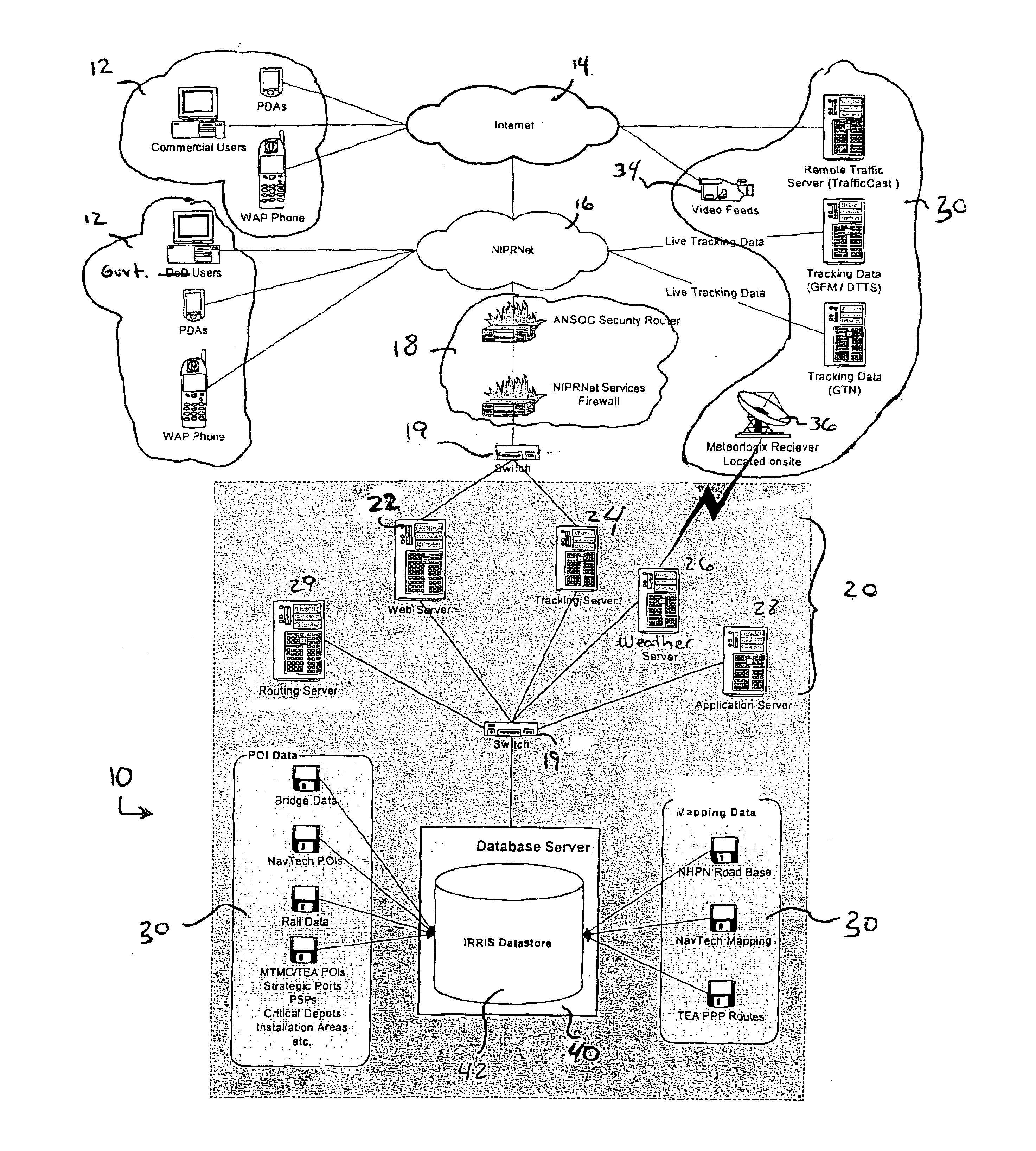
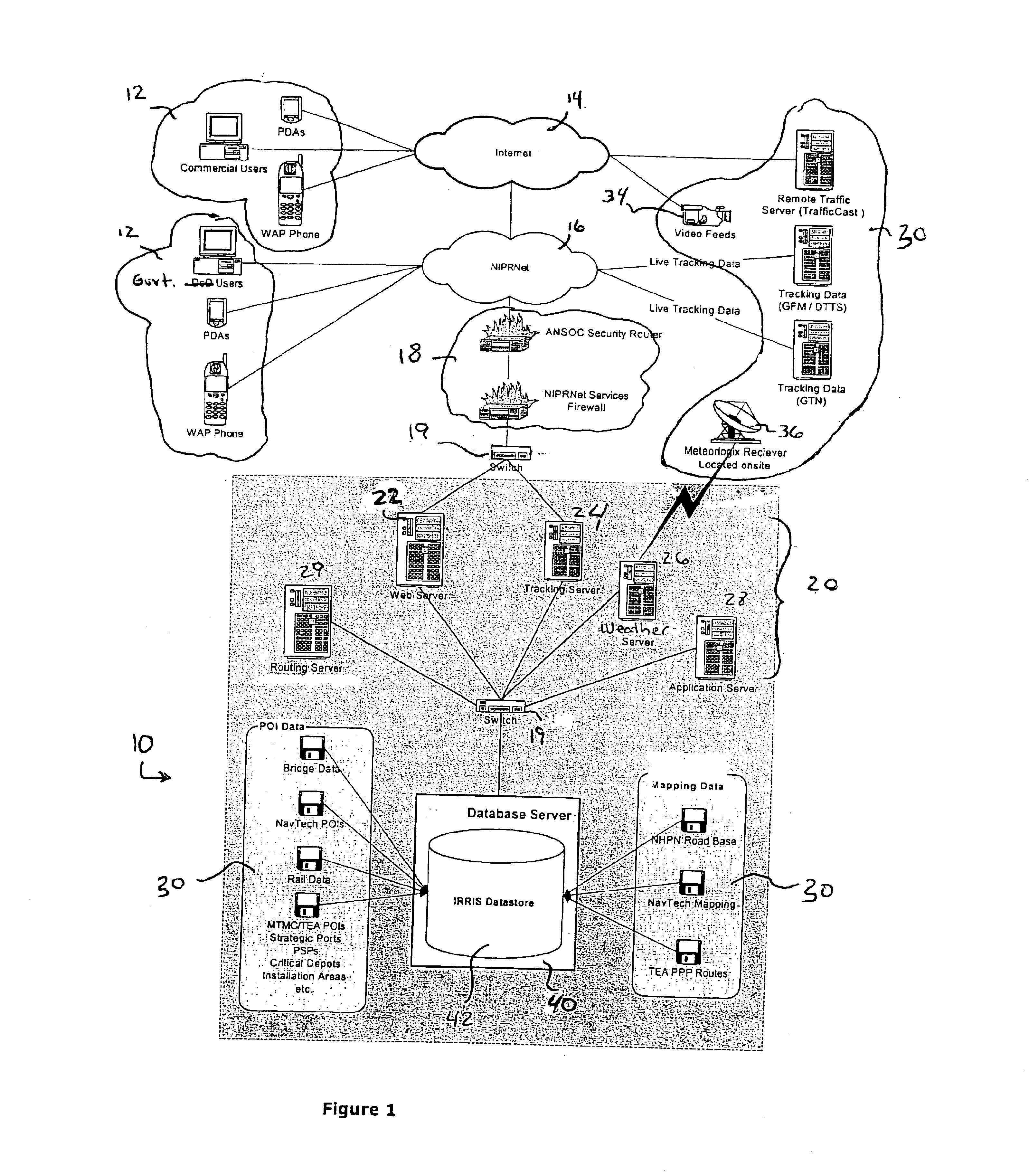
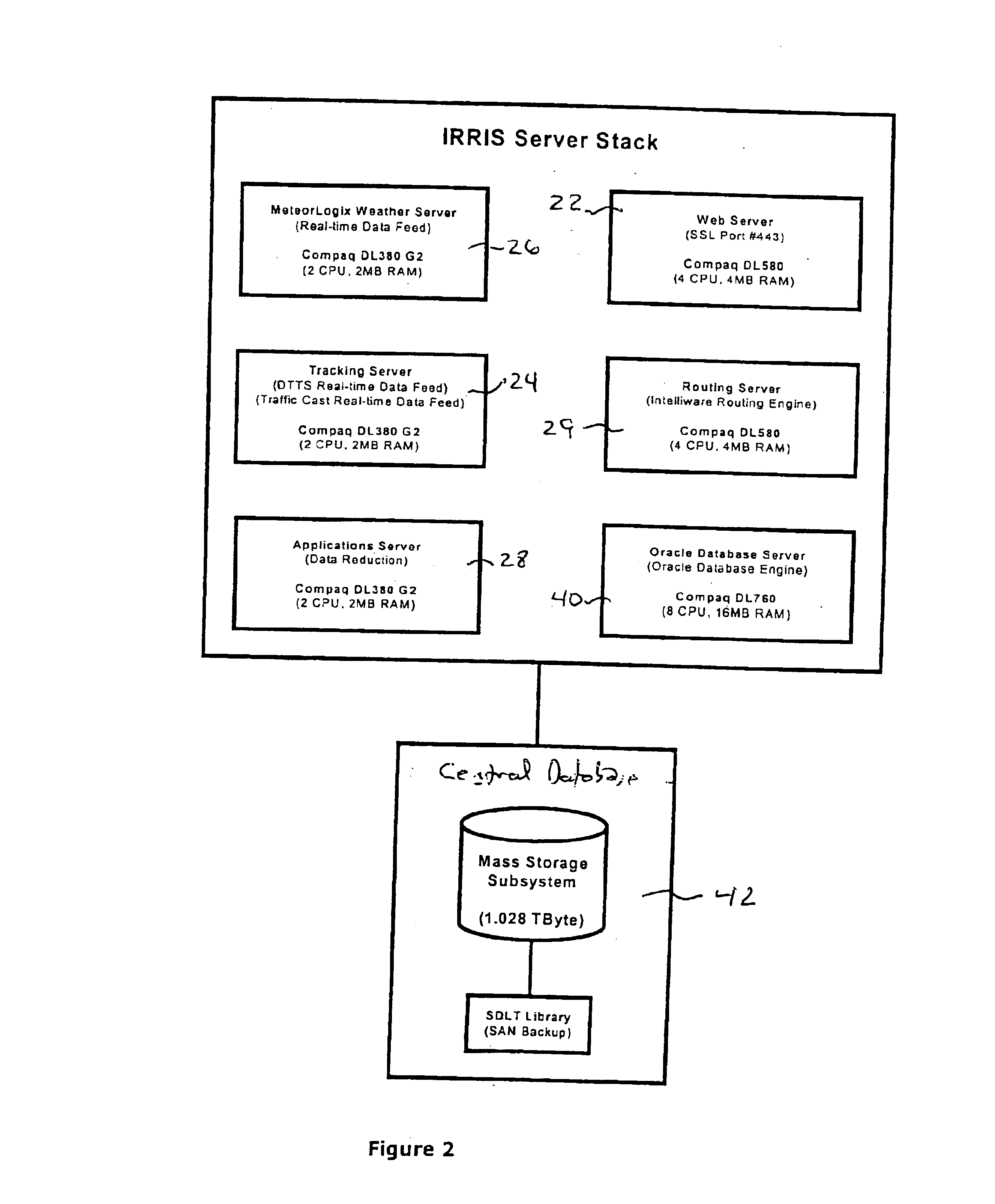
A system and method is provided for a user to access to critical information to enable and support transportation and logistics decisions at a single Internet-based interface. Users include any persons or organizations that require access to GIS and ITS information in an easy to use format to support logistics and transportation decisions, including mapping, transportation route planning, monitoring of transportation routes and weather, accidents and other incidents affecting transportation, and tracking of vehicles. For example, military and non-military governmental users, shipping and logistics companies, emergency response personnel, and any other users who have a need for timely and accurate transportation-related information can access, display, and input data into the system to enable the making of informed transportation-related decisions. The invention provides a single point of interface for detailed surface transportation infrastructure data, real-time visualization, rout...


PUM


Abstract

The present invention is a web-based transportation decision support system and geographic information system (GIS) application that leverages intelligent transportation system (ITS) information available from federal, state, local, and commercial transportation sources. The invention provides users with detailed road and rail information about routes and infrastructure characteristics, as well as real-time information from cameras, speed sensors, construction and accident reporting systems, and GIS based weather. Additionally, the invention provides users with the immediate ability to track and report surface shipments on an extremely accurate spatial data background.

Description

STATEMENT REGARDING FEDERALLY SPONSORED RESEARCH OR DEVELOPMENTThis invention was made pursuant to activities undertaken pursuant to contracts with the United States Government, and the United States Government may have certain rights in this inventionBACKGROUND OF THE INVENTIONThe present invention relates generally to computerized systems and methods which provide a user-friendly interface, such as an Internet browser, to permit client users to obtain real-time information about road conditions, construction, incidents, and weather that might interfere with the movement of people and goods.Various navigational and tracking systems and methods exist which can be used in combination with interfaces such as Internet browsers to provide users with information and displays relating to geography, maps, and weather. For example, available Internet websites can provide computer users with road maps for specified geographic areas, as well as driving directions from one specified addresses ...

Claims


Application Information

Patent Timeline
Patent Type & Authority Patents(United States)
IPC IPC(8): G01C21/00G01C21/26G06F13/00G06Q10/08G08G1/123
CPCG08G1/202G06Q10/08
Inventor SCAER, ROBERT M.POLLACK, JONATHANALLRED, JR., PAUL W.
Owner GANNETT FLEMING
Why Eureka
Try Eureka