Method and apparatus for high-accuracy position location using search mode ranging techniques

a high-accuracy, position-based technology, applied in direction finders using radio waves, instruments, wireless communication, etc., can solve the problems of inability to ensure the success of “physically locating” a target communication device, inability to automatically determine the location of conventional cellular telephones, and inability to provide assistance, so as to improve the capability of existing position-based estimation systems

Inactive Publication Date: 2005-04-05
EXCELIS INC
View PDF11 Cites 134 Cited by
  • Summary
  • Abstract
  • Description
  • Claims
  • Application Information

AI Technical Summary

Benefits of technology

Therefore, in light of the above, and for other reasons that become apparent when the invention is fully described, an object of the present invention is to provide a mobile communications device with the ability to pinpoint the physical position of a target communications device using ranging techniques, and, more particularly, to enhance the capability of existing location estimating systems with the ability to pinpoint the physical position of a target communications device.

Problems solved by technology

Unlike conventional land-based / wire-connected telephones, the location of conventional cellular telephones cannot be automatically determined by emergency response systems (e.g., the 911 system in the United States) when an emergency call is placed.
Thus, assistance cannot be provided if the caller is unable to speak to communicate his or her location (e.g., when the caller is unconscious, choking or detained against will).
Real world conditions will always exist in which position estimates, by even the most sophisticated location estimation system, will not be able to assure success in “physically locating” a target communications device.
Factors such as long distances and obstructions between the target devices and reference devices, signal degradation, and multipath distortion will impact the accuracy of trilateration based location estimates, despite the sophistication of the system deployed.
Furthermore, mission environments are often complicated by poor human operating conditions, such as darkness, smoke, heavy fog, and / or physical obstructions, resulting in situations in which even the smallest of position estimate inaccuracy can cause a search to be unsuccessful.
Even highly sophisticated position estimating techniques, such as those disclosed in patent applications '702 and '625, may yield insufficient accuracy to guarantee operational success in a number of mission environments, such as those described in the following scenarios.
Under such conditions, a conventional position estimating system, is unlikely to provide sufficient accuracy to allow rescuers to physically locate the buried individual before he suffocates.
Similar difficulties arise in a scenario in which an escaped convict, who had been previously equipped with a tracking device, has taken measures to conceal himself within the “urban canyons” of a large metropolis.
In such environments the exterior walls of city buildings create serious signal degradation and multipath conditions.
Sophisticated, trilateration based location estimation techniques alone, in such an environment, may not provide sufficient accuracy to allow law enforcement officers to plan a safe approach by which to apprehend the convict, thereby resulting in increased risk to law enforcement officers.
The inability to guarantee the ability to locate a target device in such a worst case scenario could result in the rejection of radio transponder technology that would otherwise have proven to be a highly effective tool for use in transit material tracking.
Even if multiple position estimation communications devices were moved into the surrounding area, the initial position estimate may still not provide sufficient accuracy to assure a successful search.
In many situations it is not possible to increase the number of, or to properly locate, additional communications device reference points.
Increasing the accuracy of the position estimation system may increase the cost, size, weight, and power consumption of the respective communications devices used in the 1 position estimation system, but may not assure success in physically locating a target device under all possible conditions.
Furthermore, such increased accuracy would be unnecessary in support of a large number of the missions for which such location estimation systems are intended.

Method used


Image

  • Method and apparatus for high-accuracy position location using search mode ranging techniques
  • Method and apparatus for high-accuracy position location using search mode ranging techniques
  • Method and apparatus for high-accuracy position location using search mode ranging techniques

Examples


Embodiment Construction

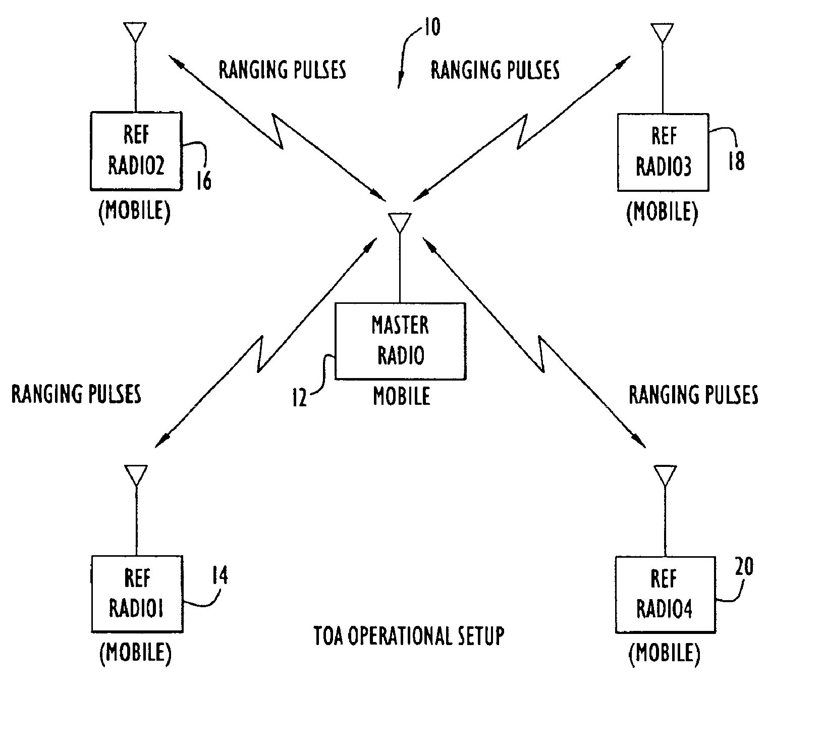
In accordance with the present invention, a handheld or portable communication device that provides accurate and reliable range information to an identical, or similar, device, within milliseconds, without interruption of audio, video or data communications. Using spread spectrum waveforms and processing techniques, the present invention is capable of determining highly accurate range information in a severe multipath environment. This range information allows the handheld or portable device to “home in” upon a designated target device.

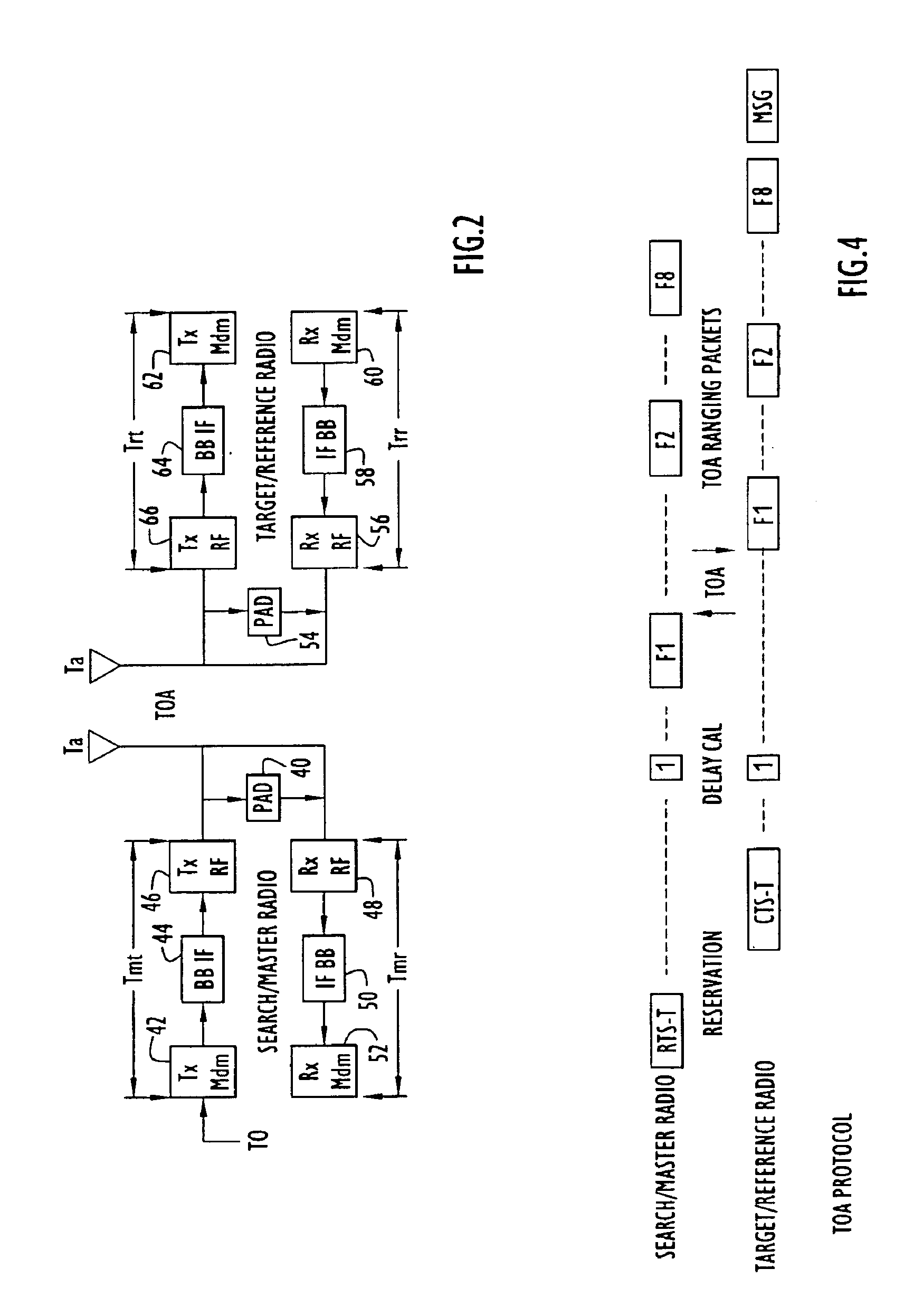
In particular, a two-way time-of-arrival messaging scheme is employed to achieve the aforementioned objectives, while eliminating the need for highly accurate system clocks required in conventional time-synchronized systems. By performing internal delay calibration, Doppler compensation, frequency diversity and leading-edge-of-the-signal curve fitting, a highly accurate estimate of ranging signal time of airival can be obtained, ensuring the accuracy ...


PUM


Abstract

A high accuracy search and tracking system that uses a round-trip messaging scheme in which the time of arrive (TOA) of ranging signals is accurately determined to yield the range estimates between a target communications device and one or more search communications devices. Successive ranging estimates are used by a search device to home in upon the target device. The physical location pinpoint communications system can be used alone, or in combination with other location estimation systems that can be used initially, or throughout the search and tracking process to pinpoint the physical location of the target device. The search radio(s) transmits ranging signals to the target radio which responds by transmitting reply ranging signals. Upon reception of the reply ranging signal, the search radio determines the range to the reference radio from the signal propagation time. Errors in TOA estimates can be minimized using advanced processing techniques, if required.

Description

BACKGROUND OF THE INVENTION1. Field of the InventionThe present invention relates to the enhancement of position estimating systems with the ability to pinpoint the physical location of a target communication device using direct ranging techniques between search communication devices and the target communication device.2. Description of the Related ArtThe capability to rapidly and accurately estimate the physical position of a mobile communication device would be of great benefit in a variety of applications. In a military context, it is desirable to know the location of military personnel and / or equipment during coordination of field operations and rescue missions, including scenarios where signals of conventional location-determining systems, such as global location system (GPS) signals, may not be available (e.g., within a building). More generally, appropriately equipped mobile communication devices can be used to track the location of personnel and resources located both indoor...

Claims


Application Information

Patent Timeline
Patent Type & Authority Patents(United States)
IPC IPC(8): G01S1/00G01S1/02G01S5/14H04Q7/38G01S19/22H04W64/00
CPCG01S1/022H04W64/00G01S5/14G01S2205/002
Inventor MARTORANA, MARC J.
Owner EXCELIS INC
Why Eureka
Try Eureka