
Navigation method and navigation system for motor vehicles

a navigation system and motor vehicle technology, applied in the direction of direction finders using radio waves, navigation instruments, instruments, etc., can solve the problems of requiring a certain amount of basic skill in operating the navigation system, requiring a certain amount of input time, and complicated time-consuming, so as to facilitate and direct the effect of the devi

Inactive Publication Date: 2005-05-03
ROBERT BOSCH GMBH
View PDF23 Cites 172 Cited by
  • Summary
  • Abstract
  • Description
  • Claims
  • Application Information

AI Technical Summary

Benefits of technology

[0004]An object of the present invention is to provide an improved method and an improved device of the type mentioned above which overcome the above-mentioned disadvantages and provide a user with optimum support even at times of elevated stress in emergency situations.
[0006]This has the advantage that, in an emergency, the navigation system can provide valuable assistance in directing the user to the nearest emergency destination, for example a hospital, a fire station or a police station, without time consuming input or programming work. This adds an important additional route selection function to the functionality of a navigation system.
[0009]According to an advantageous embodiment of the present invention, after selecting the emergency destination for which the route is calculated, the emergency destination is notified, preferably automatically, of the vehicle's arrival. This gives the emergency destination enough time to prepare for the arrival of the affected vehicle and thus to take any necessary measures. In particular, an emergency room of a hospital, for example, can be selected as an emergency destination and be prepared in good time for the arrival of an accident victim or a patient.
[0010]It is also advantageous for the selected emergency destination to provide the driver of the nearing vehicle with a selection of possible or probable diagnoses, from which the vehicle driver can select the one most applicable to his or her situation and have it communicated to the emergency destination. This can further improve efforts by the emergency destination to prepare for the arriving vehicle and provide faster and more specific treatment or care for the vehicle driver or vehicle passengers.
[0012]According to another advantageous embodiment of the present invention, a communications link to an external database, for example in the form of a service center, is set up via a communications interface, and the selected emergency destination—or the group of emergency destinations offered for selection—is supplied to the navigation system over the communications link. This has the advantage that the latest information about emergency destinations, which is maintained, for example, by the service center, is always available. In addition, at times outside normal business hours, such as at night, over the weekend or on public holidays, the selection of emergency destinations can be limited to only those that actually have an emergency service—in the case of a medical emergency service, for example, the nearest doctor's office offering a weekend emergency service.
[0013]A user-friendly operability is achieved by providing a manually operated key to activate the device for selecting an emergency destination closest to the present location. This makes it possible to easily and directly activate the device for selecting an emergency destination closest to the present location.

Problems solved by technology

However, this is both complicated and time-consuming and requires a certain amount of basic skill in operating the navigation system.
This input also takes a certain amount of time, which can be especially disadvantageous if the user is having an emergency in an unknown area and must quickly reach, for example, a hospital or police station.
The need to first laboriously determine the location, for example, of the nearest hospital and program the navigation system to calculate a route to this nearest hospital takes up valuable time.
Furthermore, it has been frequently observed that people involved in emergencies and suffering from the associated stress, often are no longer capable of remembering generally known emergency medical numbers (112 or 19222) and are certainly no longer able to enter information quickly and correctly into the navigation system.
In such extraordinary circumstances, a person involved in an emergency in familiar surroundings often can no longer easily recall even a normally well known route to the nearest hospital.

Method used


Image

  • Navigation method and navigation system for motor vehicles
  • Navigation method and navigation system for motor vehicles

Examples


Embodiment Construction

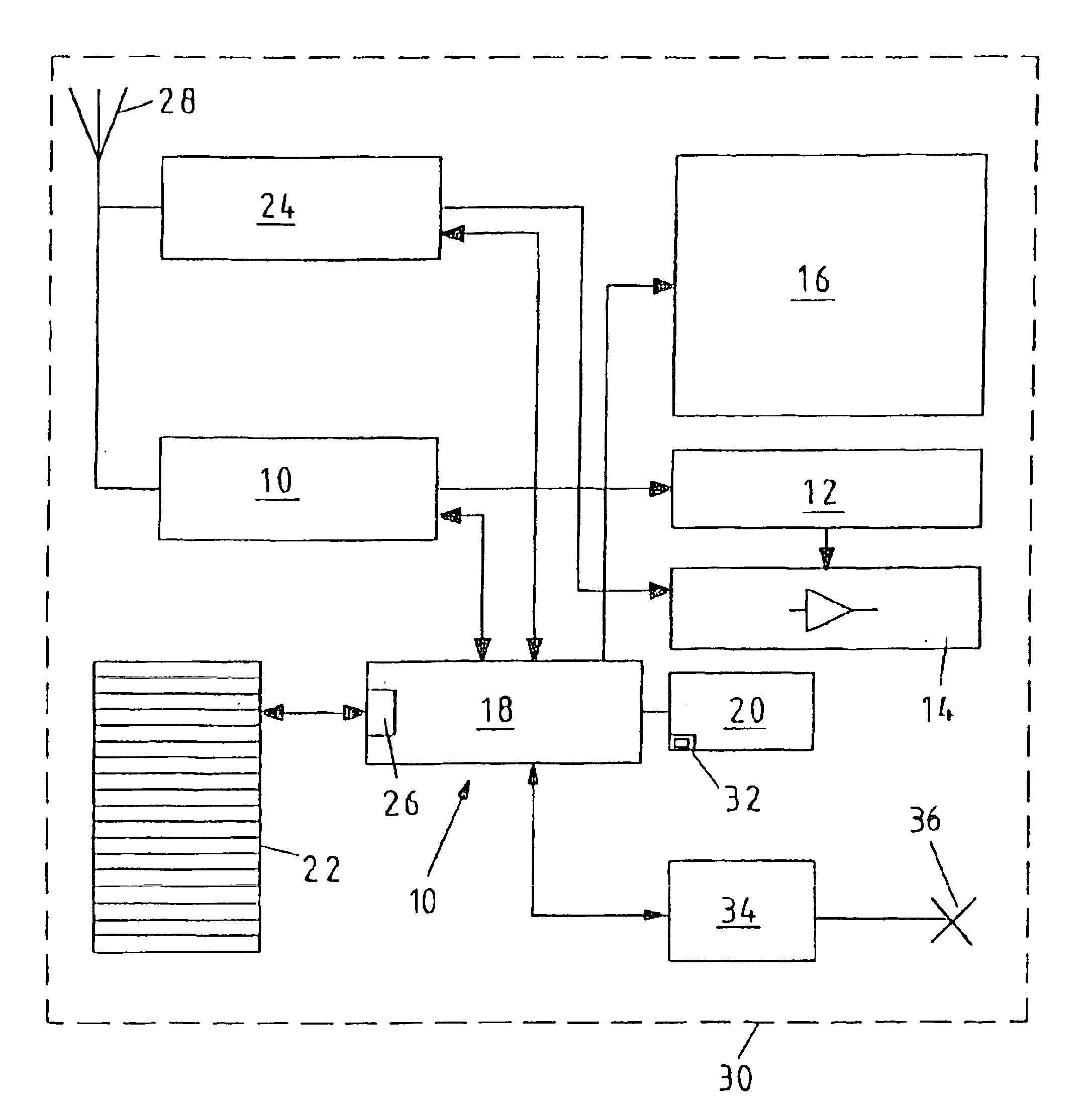
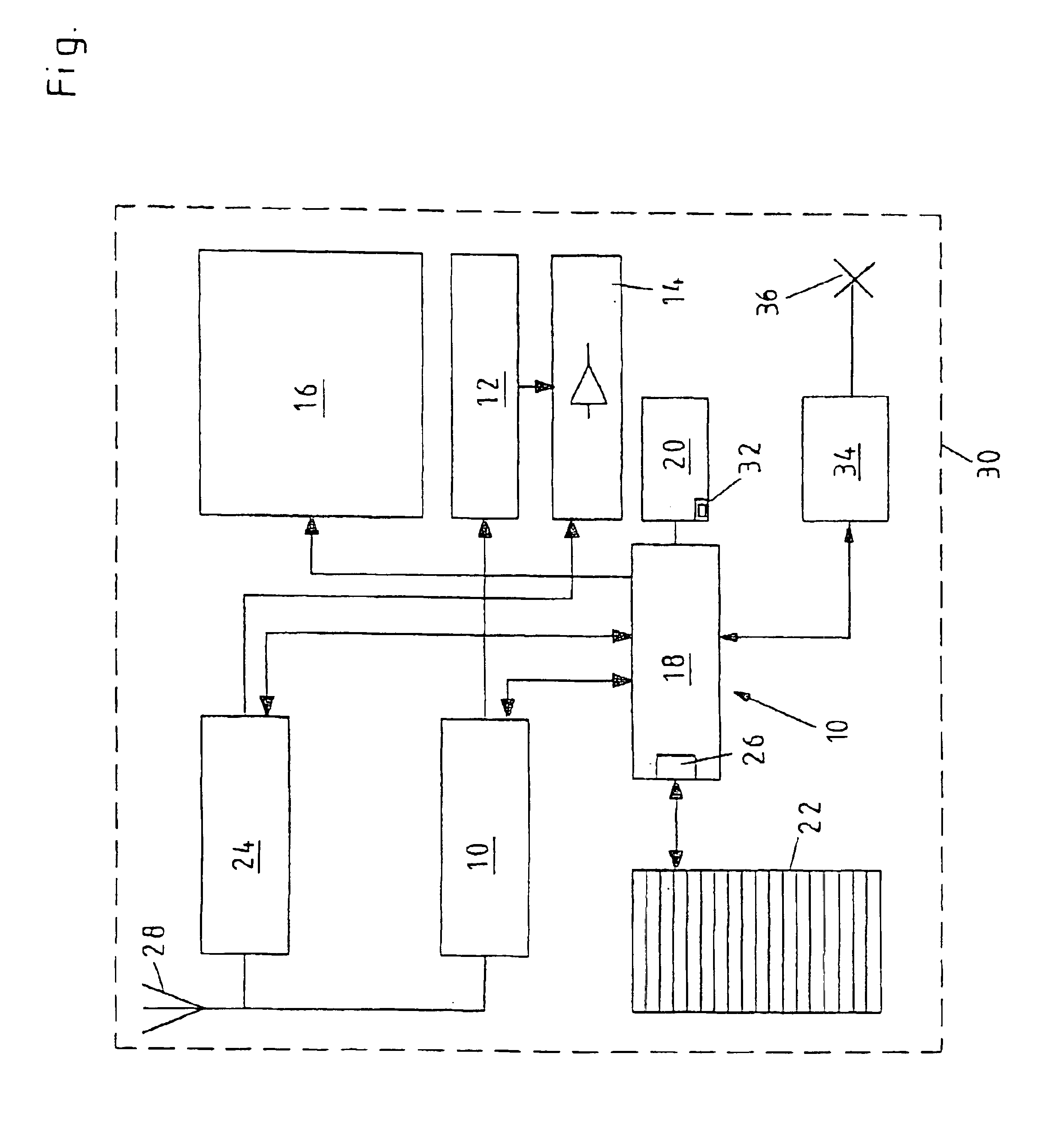
[0015]The preferred embodiment of a navigation system 100 according to the present invention and illustrated in the Figure includes a destination guidance system 10 with acoustic road guidance 12 via a speaker unit 14, a display unit 16 to display, for example; “destination, city, street,” a microprocessor 18 with a user interface in the form of a keypad 20, a memory 22 for emergency destinations, a radio receiver 24 that is also connected to speaker unit 14, and an antenna 28 that is connected to both radio receiver 24 and destination guidance system 10. The above-mentioned components are located in or on a motor vehicle identified by reference number 30, which is indicated only by broken lines.

[0016]A database of emergency destinations in a digital map base of the navigation system, which represents an actual road grid, is stored in memory 22. Emergency destinations of this type are, for example, hospitals, police stations, public telephones, emergency call boxes and / or fire stati...


PUM


Abstract

Navigation method and navigation system for motor vehicles for navigating from a present location to a destination. In response to an emergency user request, an emergency destination closest to the present location is selected from a database, set as the destination, and a route calculated from the present location to the emergency destination. The navigation system includes a memory having a database for emergency destinations and a device for selecting, from the database, an emergency destination closest to the present location.

Description

FIELD OF THE INVENTION[0001]The present invention relates to a navigation method and a navigation system for motor vehicles for navigating from a present location to a destination.BACKGROUND INFORMATION[0002]In means of conveyance, such as motor vehicles, airplanes or ships, permanently installed navigation systems quickly, easily and reliably guide the driver of the means of conveyance from a present location to a desired destination without requiring the driver of the means of conveyance to go to the trouble of planning a route and obtaining the appropriate maps ahead of time. For this purpose, navigation data based on, for example, charts, geographic maps or road maps are stored in the navigation system, for example on CD-ROM. The navigation system uses, for example, a global positioning system (GPS) to determine a present location and calculate navigation instructions that lead to a predetermined destination. The navigation data preferably includes information about roads and ro...

Claims


Application Information

Patent Timeline
IPC IPC(8): G01C21/34G08G1/0968G01C21/00G09B29/00G08G1/0969G09B29/10
CPCG01C21/3407G01C21/3611G08B25/006G08G1/096894G08G1/096838G08G1/09685G08G1/096883G08G1/096827
Inventor RYCHLAK, STEFAN
Owner ROBERT BOSCH GMBH
Learn More